Mini Project 1: Image Interpretation using Google Earth
The use of aerial photography for archaeological image interpretation is not a new technique, with the 1906 Stonehenge exploration via army balloon thought to be the earliest example in England.[1] However a significant improvement in the technologies available has expanded the potential benefits of such methods.[2] The approach can now assist archaeologists in effectively monitoring Scheduled Monuments, allowing subtle changes overtime to be detected.[3] Aerial and satellite image interpretation also allows researchers to identify sites of potential interest quicker, and over a wider area, compared to ground visits alone. This is particularly useful when the landscape is at risk of disturbance and protected status must be allocated quickly.[4]
Taking the example of St Andrew’s Dock, Hull – which closed in 1975 and has seen no redevelopment since – satellite imagery reveals the clearly defined shape of the old dock (Figure 1: A), lock (Figure 1: B), and bullnose (Figure 1: N), as well as a disused road which serviced the quay (Figure 1: C). Further, the position of the derelict buildings remaining (Figure 1: K – N) can be understood better relative to the wider landscape they were originally constructed amongst, especially as the outlines of now demolished buildings can still be observed (Figure 1: D – J).
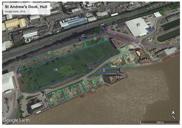
Legend (for Figure 1):
A – St Andrew’s Dock
B – Two sets of lock gates (though only one set remains intact) towards St Andrew’s Dock
C – North Road including a subway tunnel north, originally towards Hessle Road connected via Subway Street.
D – Billingsgate Fish Market
E – Ice Factory
F – J. Marr & Son Ltd., seafoods
G – Various smaller building/units, including a bank and a working man’s club when the dock closed in the 1970s.
H – Various smaller dock buildings/units
I – Various smaller dock buildings/units
J – Humber-St Andrew’s Engineering Works
K – Lord Line, shipping office
L – Hydraulic Pump House
M – Globe Engineering, insurance building
N – Dock building
O – Jetty
P – Jetty
Q – St Andrew’s Quay Retail Park
R – Cranswick plc.
The imagery was analysed for any visible defined shapes, and areas of differing colour or texture, which can indicate the remnants of a manmade structure (as seen in Figure 1: C – J). After the sites of interest were identified, historic GIS Ordnance Survey maps (such as those utilised in Map Analysis) were used alongside twentieth century photography, including that in Fish Dock, to assign function to the structures.[5] In the case of St Andrew’s, where the recent history is fairly well documented, the use of image interpretation can still provide unique insights. For instance, the dimensions of now demolished buildings can be taken and historical photography may be better attributed to its exact position, allowing a fuller understanding of the history of the dockland to be had.
[1] Robert H. Bewley, “Aerial Survey for Archaeology,” Photogrammetric Record 18 (2003): 274.
[2] Bob Bewley and Kieron Niven, “Guides of Good Practice: Aerial Photography and Interpretative Mapping,” Archaeology Data Service, accessed 3 January 2024, https://archaeologydataservice.ac.uk/help-guidance/guides-to-good-practice/data-collection-and-fieldwork/aerial-survey/aerial-photography-remote-sensing/aerial-photography-and-interpretative-mapping/.
[3] Bewley, Aerial Survey, 277.
[4] Louise Rayne, et al., “From Above and on the Ground: Geospatial Methods for Recording Endangered Archaeology in the Middle East and North Africa,” Geosciences 7 (2017): 111.
[5] Michael Thompson, Fish Dock: The Story of St. Andrew’s Dock Hull (Beverley: Hutton Press, 1989).