Mini Project 4: Uses of AR/VR within Public History
Title:
Hull Docklands: Heritage Trail
Overview:
The project allows participants to explore some of Hull’s historic docklands through AR technology and oral histories. The testimony used consists of archived written sources and interviews, taken from a diverse range of individuals linked to the seafaring community past and present.
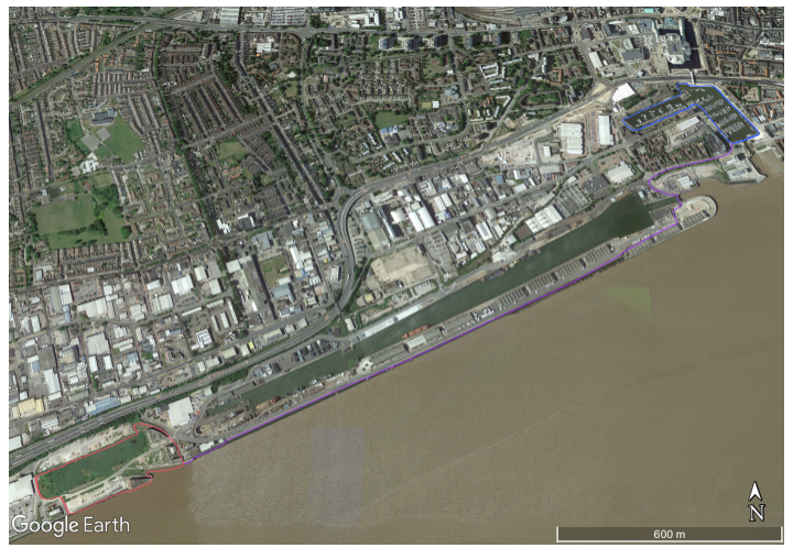
A downloadable app allows users to screen AR and hear testimony on their smartphone when they move through interactive sites, tracked by GPS. Within these sites (figure 1) there will be ‘interactive zones’, whereby the app will play an alert prompting the individual to stop and observe an AR-generated, 360-degree view of the past, overlaying the present. They can also interact with personal testimonies in these zones, through interaction with characters. There is no formal order to exploration, nor do the sites have to be visited in one day, meaning greater freedom for the user. As the landscapes contain hazards, such as open water and uneven ground, the experience must be limited to ‘interactive zones’ to protect the individual. However, this allows the participant to become more engrossed in the present landscape as they explore the sites to locate ‘zones’.
Designated Sites:
Site A: St Andrew’s Dock (Figure 1: red)
Site B: Public footpath connecting sites A and C (Figure 1: purple)
Site C: Hull Marina (Figure 1: blue)
Aims:
- Allow interaction with Hull’s maritime heritage.
- Explore a diverse range of testimony, expanding beyond the typical ‘trawlerman viewpoint’.
- Use AR to encourage exploration of the landscape and visible remnants of the past.
- Consider the communities built by past and present maritime activity.
Target Audience:
The experience is primarily for adults who want to learn and interact with the city’s maritime heritage. Due to the hazardous nature of the sites, the experience cannot be recommended for children.
Technology:
The app, when opened in an ‘interactive zone’, will display an artist’s realistic interpretation of the historic landscape imposed onto the present. The docklands were well photographed during the twentieth century and, as such, will be used for reference. GPS alerts participants when they enter an ‘interactive zone’ and prompts the displayed picture to change as they move their phone.
Acts and Elements –
Act 0: Site A, B, or C
Plot Time – Present day
Space – The experience will begin Site 1, 2, or 3 – user dependent.
Role – Participants will have already downloaded or will download the app onsite.
Interface – Upon opening the app, users are onboarded with an explanation of the experience and technology, before being encouraged to explore to locate ‘interactive zones’ for an AR experience.
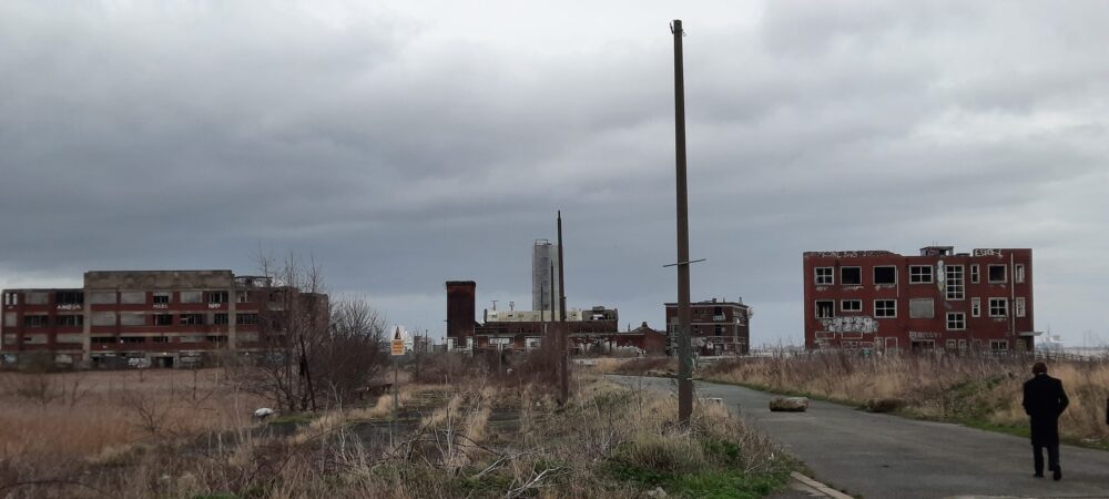
Act 1: Site A – St Andrew’s Dock
Plot Time – Site A explores the post-war period, whereby a boom in the fishing industry in the 1950s and sixties occurred. The 1968 Triple Trawler Tragedy and the Headscarf Revolutionaries will also be discussed in the testimony as important events during the period.
Space – Participants move about St Andrew’s Dock. Within this space multiple, now derelict, dock buildings still stand (although access inside is not possible), as well as the partly filled dock.
Role – Participants explore the site uninhibited by the technology, encouraged to examine points of interest within the landscape. After entering an ‘interactive zone’ they use their phone to explore the digital landscape and interact with characters.
Interface – The user is encouraged to locate ‘interactive zones’, with GPS alerting the individual when entering a zone. Users open the app and can view an accurate interpretation of the historic landscape through an AR lens and interact with nearby characters.
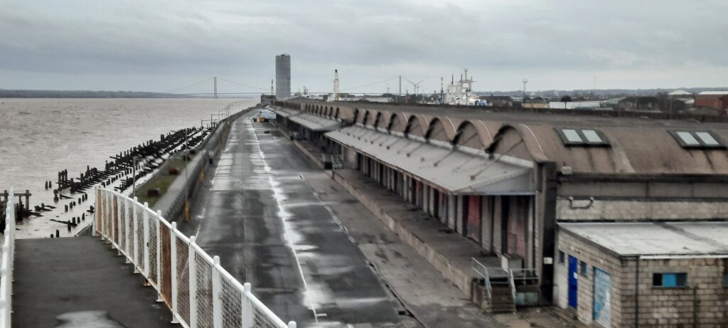
Act 2: Site B – Public footpath alongside William Wright and Albert Docks
Plot Time – Site B explores c.1900 when the landing site along the dock was used to welcome passengers – often migrants from north-western Europe. Accounts from migrants will be re-enacted as part of character interaction for this site.
Space – Participants walk along the bank of the Humber on the footpath, connecting sites A and C. To the north, individuals can see a dock in active use, and south is the Humber estuary.
Role – Participants explore uninhibited by the technology, interacting with points of interest in the landscape. Once users enter an ‘interactive zone’ they use their phone to explore the digital landscape and interact with characters to hear their testimony.
Interface – Users are encouraged to locate ‘interactive zones’, with GPS tracking alerting the individual when they enter a zone. They then open the app to view an accurate interpretation of the historic landscape through an AR lens and interact with nearby characters.
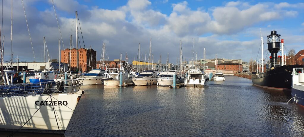
Act 3: Site C – Hull Marina (previously Humber and Railway docks)
Plot Time – Site C explores dock activity c.1850 during its heyday; showcasing the diverse trade which flowed through Hull, including fruit and vegetables, coal, and timber, and the international links this gave the town.
Space – Both Humber and Railway docks are now used for leisure craft. Many original building facades are still visible, plus other clues to the area’s history, such as railway tracks in the cobbled street on the westside.
Role – Participants explore the site uninhibited by the technology, encouraged to examine points of interest. After entering an ‘interactive zone’ they can use their phone to explore the digital landscape and interact with characters to hear testimonies.
Interface – Users are encouraged to locate ‘interactive zones’, with GPS alerting the individual when they enter an area. Opening the app, they can view a realistic interpretation of the historic landscape through an AR lens and interact with nearby characters.
Act 4: Site A, B, or C
Plot Time – Past and present
Space – The experience will end Site 1, 2, or 3 – user dependent.
Role – Participants exit the app and return to their present self.
Interface – No interface is in use after exiting the app.