Statutory Address: 11-14 Nelson Street, Hull, HU1 1XE
Coordinates: 53°44’18″N 0°19’58″W
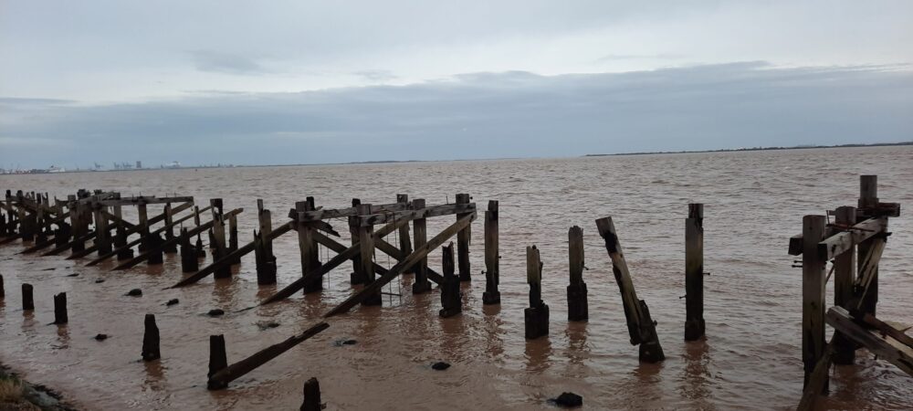
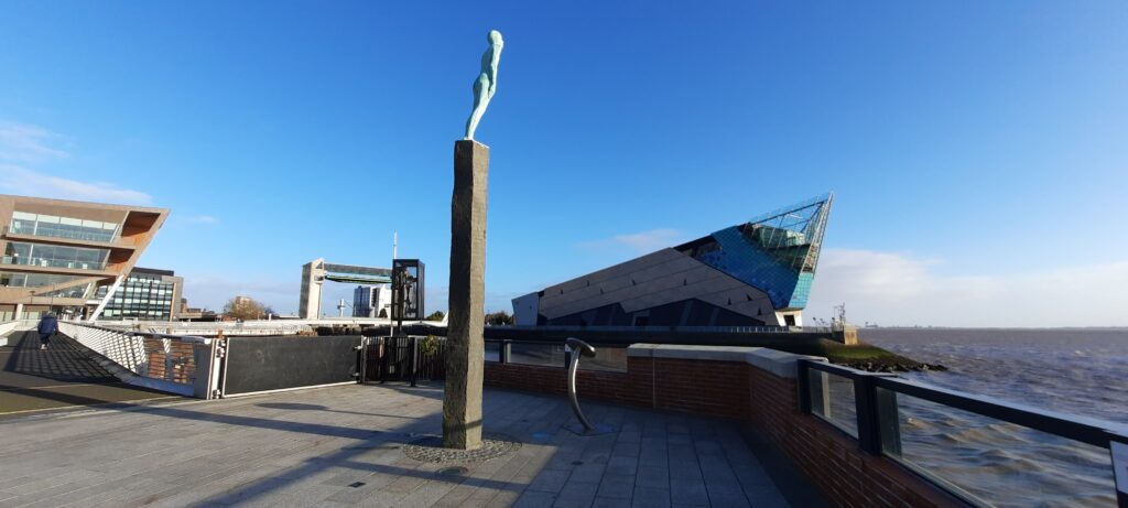
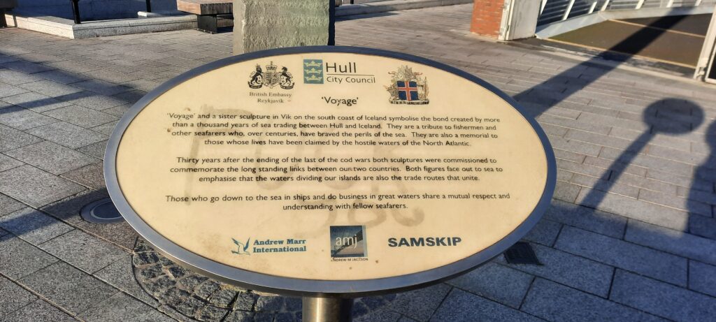
Figure 1: Megan Seeney, Voyage sculpture, Nelson Street, with The Deep in the background, 2023, digital photograph.Figure 2: Megan Seeney, Voyage sculpture, Nelson Street, Hull, 2023, digital photograph.Figure 3: Megan Seeney, A close-up of the information board for Voyage, Nelson Street, Hull, 2023, digital photograph.
Description of Location –
Located above road level on Nelson Street, the former location of the Ferry Boat Docks which connected Hull with Lincolnshire. Opposite The Deep aquarium, where the rivers Hull and Humber meet.
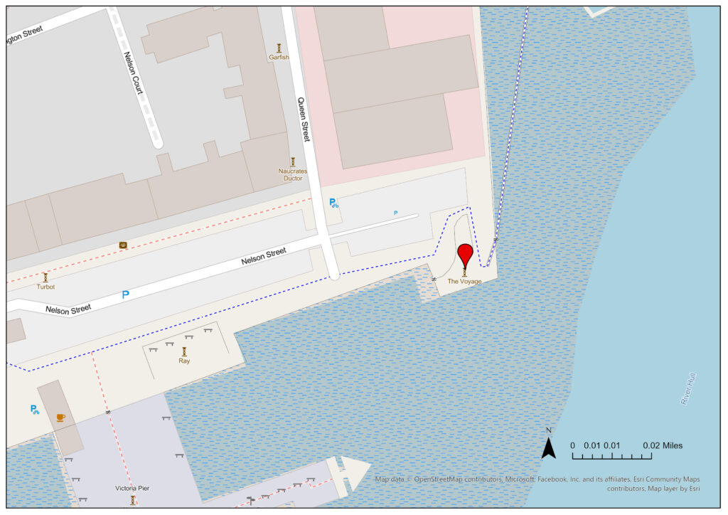
Figure 4: Megan Seeney, “Voyage”, JPEG map, Scale 1:1000, Open Street Map, December 2023, ArcGIS, created 15 January 2024.
Details –
Erected: The original was erected in 2006. This was stolen in July 2011 but was replaced by Hull City Council in May 2012.
Listed: Not listed
Monument Type: Art sculpture
Associated Site(s): Sister sculpture ‘För’ in Vik, Iceland. Also, the Grade II listed William de-la-Pole statue, former Pilots Office, former Corporation Pier Station, Minerva Hotel are also located in relatively close proximity.
Inscription(s): “Vik Iceland 1534km”
“Voyage 2006 Steinunn Thorarinsdottir”
“‘Voyage’ and a sister sculpture in Vik on the south coast of Iceland symbolise the bond created by more than a thousand years of sea trading between Hull and Iceland. They are a tribute to fishermen and other seafarers who, over centuries, have braved the perils of the sea. They are also a memorial to those whose lives have been claimed by the hostile water of the Northern Atlantic. Thirty years after the ending of the last of the cod wars both sculptures were commissioned to commemorate the long standing links between our two countries. Both figures face out to sea to emphasise that the waters dividing our islands are also the trade routes that unite. Those who go down to the sea in ships and do business in great waters share a mutual respect and understanding with fellow seafarers.”
Description: Voyage consists of a six-foot-tall bronze figure leaning forward towards the river Humber on top of a tall stone column and surrounded by a stone compass on the floor. The sculpture was created by Icelandic artist Steinunn Þórarinsdóttir and is facing the down the estuary towards the sea. There is a sister statue in the village of Vik, Iceland which faces out towards Hull. The art project commemorates the long history of trade between Hull and Iceland (which continues), as well as recognising the tension caused by the Cod Wars (1958-1961, 1972-1973, and 1975-1976).
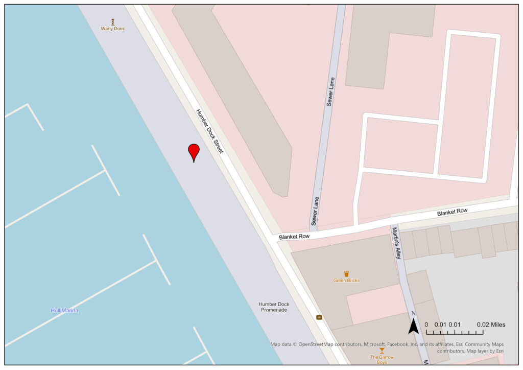
Statutory Address: Humber Dock Street, Hull, HU1 1TB
Coordinates: 53°44’24″N 0°20’13″W
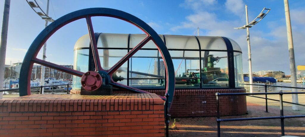
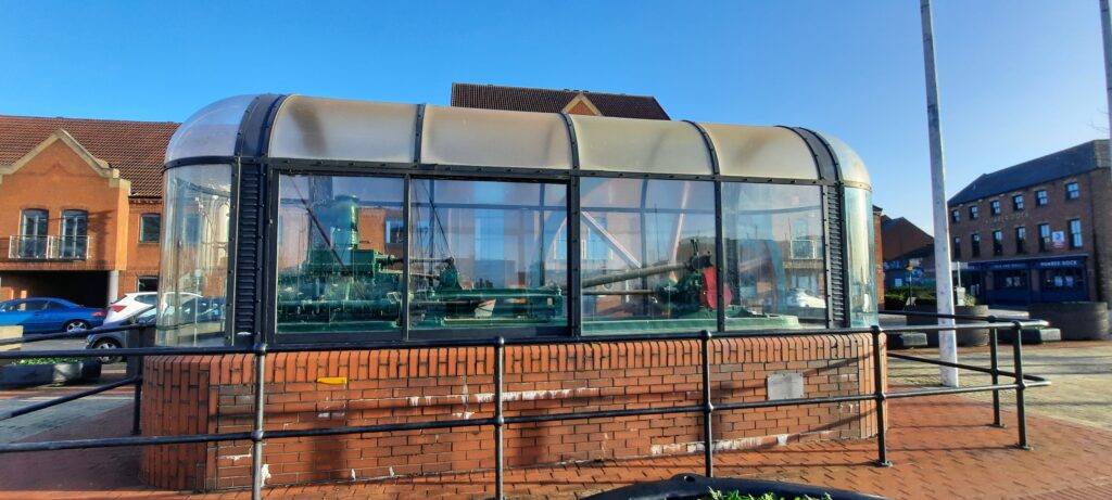
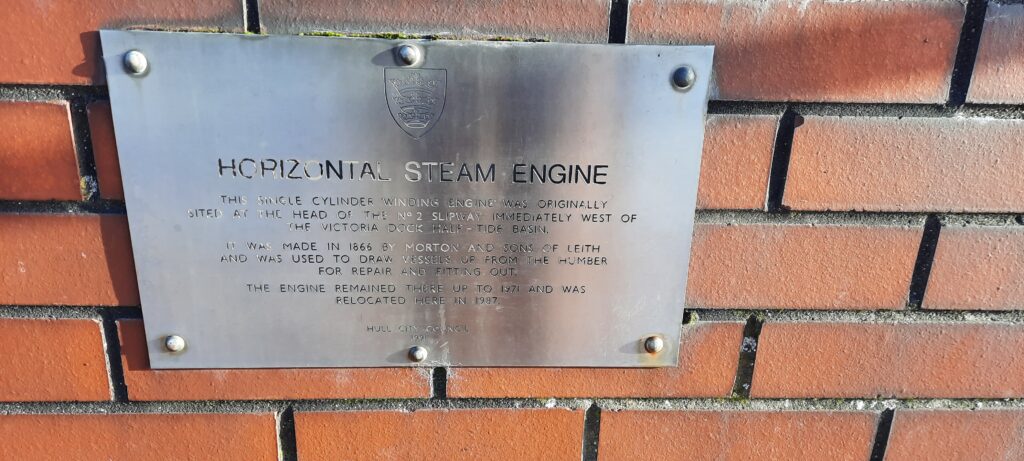
Figure 1: Megan Seeney, Horizontal Steam Engine, Humber Dock Street, facing Hull Marina, 2023, digital photograph.Figure 2: Megan Seeney, Horizontal Steam Engine, Humber Dock Street, 2023, digital photograph.Figure 3: Megan Seeney, A close-up of the inscription on the side of the Horizontal Steam Engine, Humber Dock Street, 2023, digital photograph.
Description of Location –
Located on the east side of Hull Marina (previously Humber Dock).
Figure 4: Megan Seeney, “Horizontal Steam Engine”, JPEG map, Scale 1:1000, Open Street Map, December 2023, ArcGIS, created 15 January 2024.
Details –
Erected: 1987
Listed: Not listed
Monument Type: Historical Interest
Associated Site(s): Not Applicable
Inscription(s): “Horizontal steam engine. The single cylinder ‘winding engine’ was originally sited at the head of the No.2 slipway immediately west of the Victoria Dock Half-tide Basin. It was made in 1866 by Morton and Sons of Leith and was used to draw vessels up from the Humber for repair and fitting out. The engine remained there up to 1971 and was relocated here in 1987. Hull City Council 1991.”
Description: A preserved horizontal single cylinder steam engine, built in 1866, and presented in a clear plastic case at street level alongside the marina. It was designed and constructed by Morton and Sons of Leith and was formerly used to haul ships out of the water on the slipway at Victoria Dock.
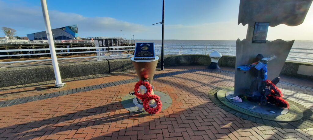
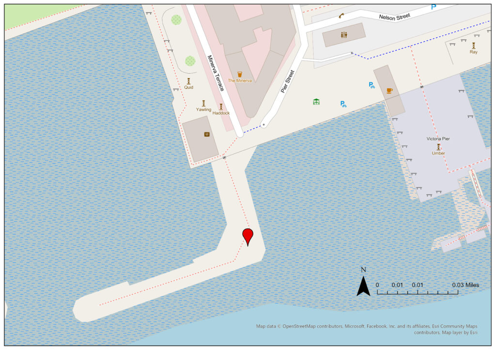
Statutory Address: Minerva Pier, Henry Vernone Cresent, Hull, HU1 1AZ
Coordinates: 53°44’15″N 0°20’06″W
Figure 1: Megan Seeney, The Merchant Navy Memorial with Victoria Pier in the background, 2023, digital photograph.Figure 2: Megan Seeney, The Merchant Navy Memorial alongside the Royal Navy Memorial with The Deep in the background, 2023, digital photograph.Figure 3: Megan Seeney, A close-up of the inscription on the Merchant Navy Memorial, Minerva Pier, Hull, 2023, digital photograph.
Description of Location –
Located on Minerva Pier (built late 20th century, replacing an earlier 19th century pier; originally known as East pier) which extends out into the Humber and forms part of the entrance into the Humber basin, which leads to the marina (previously Humber Dock).
Figure 4: Megan Seeney, “The Merchant Navy Memorial”, JPEG map, Scale 1:1000, Open Street Map, December 2023, ArcGIS, created 15 January 2024.
Details –
Erected: Unknown
Listed: Not listed
Monument Type: Memorial
Associated Site(s): The Royal Navy Memorial is in close proximity.
Inscription(s): “Dedicated to the men and women of the merchant navy who gave their lives for the freedom of others. Many lay in foreign lands. For most they have no grave by the sea.”
“Presented by the Hull M. N. Association.”
Description: A memorial, presented by the Hull Merchant Navy Association, commemorating all merchant navy personnel who died whilst in service and who were either buried abroad or at sea. The memorial consists of an inscribed black stone tablet on top of a steel pedestal, footed by an anchor. There are two flagpoles also located at the site.
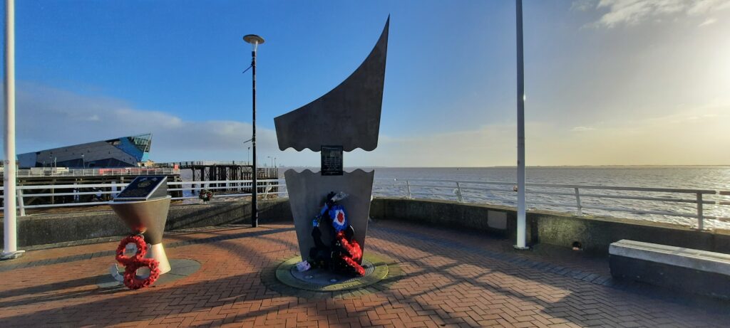
Statutory Address: Minerva Pier, Henry Vernone Cresent, Hull, HU1 1AZ
Coordinates: 53°44’15″N 0°20’06″W
Figure 1: Megan Seeney, The Royal Navy Memorial, Minerva Pier, Hull, 2023, digital photograph.Figure 2: Megan Seeney, The Royal Navy Memorial alongside the Merchant Navy Memorial with The Deep in the background, 2023, digital photograph.Figure 3: Megan Seeney, A close-up of the inscription on the Royal Navy Memorial, Minerva Pier, Hull, 2023, digital photograph.
Description of Location –
Located on Minerva Pier (late 20th century, replacing an earlier 19th century pier; originally known as East pier) which extends out into the Humber and forms part of the entrance into the Humber basin, which leads to the marina (previously Humber Dock).
Figure 4: Megan Seeney, “The Royal Navy Memorial”, JPEG map, Scale 1:1000, Open Street Map, December 2023, ArcGIS, created 15 January 2024.
Details-
Erected: Unknown
Listed: Not listed
Monument Type: Memorial
Associated Site(s): The Merchant Navy Memorial is in close proximity
Inscription(s): “A Naval Memorial. In remembrance of all Royal Navy personnel who gave their lives during the 1914-1918 war, the 1939-1945 war and all wars and subsequent conflicts. We will remember them.”
“To them we owe a debt of honour.”
Description: A memorial, presented by The Royal Naval Association Hull Branch, commemorating all Royal Navy personnel who were killed during the First and Second World Wars and all conflicts since. The memorial consists of inscribed black stone tablet within a larger metal sculpture, footed by a metal anchor. There are two flagpoles also located at the site.
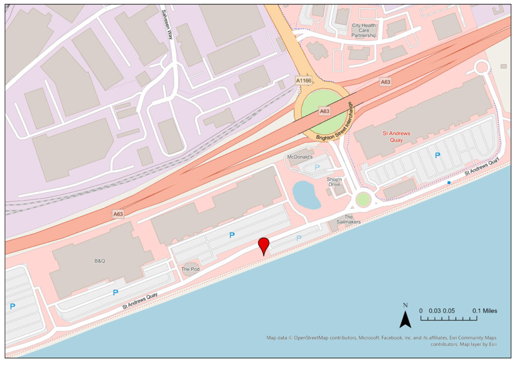
Statutory Address: St Andrew’s Quay, Hull, HU3 4SA
Coordinates: 53°43’34″N 0°22’34″W
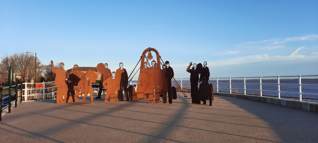
Figure 1: Megan Seeney, St Andrew’s Memorial to Lost Trawlermen, St Andrew’s Quay, Hull, 2023, digital photograph.
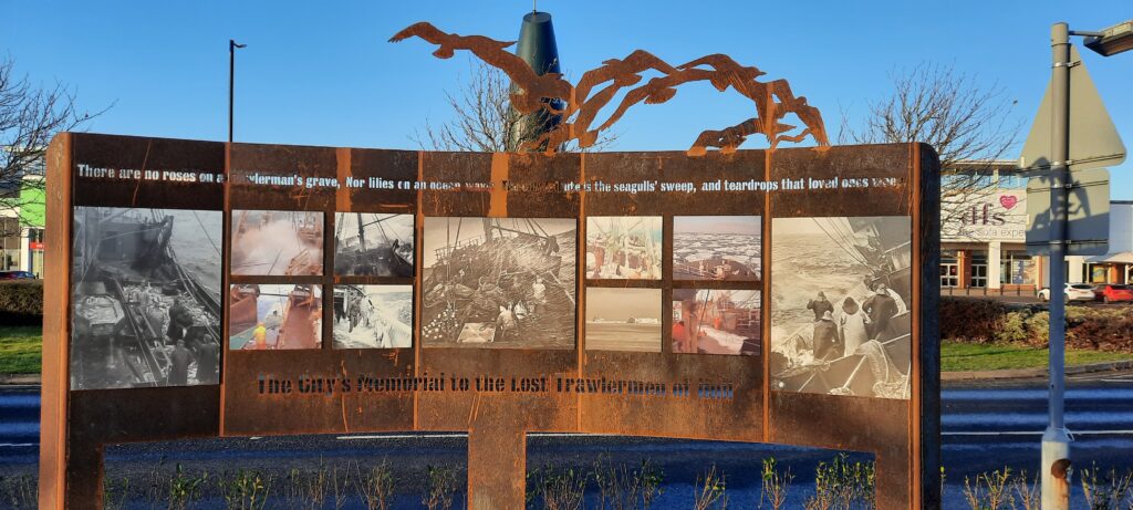
Figure 2: Megan Seeney, St Andrew’s Memorial to Lost Trawlermen from inside the memorial garden, St Andrew’s Quay, Hull, 2023, digital photograph.Figure 3: Megan Seeney, Entrance Arch to the memorial garden for lost trawlermen, St Andrew’s Quay, Hull, 2023, digital photograph. Figure 4: Megan Seeney, An information board within St Andrew’s Memorial to Lost Trawlermen, St Andrew’s Quay, Hull, 2023, digital photograph.
Description of Location –
Located on the site of St Andrew’s Dock (‘Fish Dock’), with the western dock area (where the memorial is located) now a retail shopping park. The dock was once home to the world’s largest deep sea fishing fleet. Shipping activity in the quay ended on 3 November 1975.
Figure 5: Megan Seeney, “St Andrew’s Memorial to Lost Trawlermen”, JPEG map, Scale 1:5,000, Open Street Map, December 2024, ArcGIS, created 15 January 2024.
Details –
Erected: Steel sculptures were erected in 2017 but were removed to facilitate the construction of flood defences in 2019. The project was fully completed in September 2023, with the steel sculptures being reinstalled amongst a wider ceremonial area.
Listed: Not Listed
Monument Type: Memorial
Associated Site(s): Not Applicable
Inscription(s): “There are no roses on a trawlerman’s grave, Nor lilies on an ocean wave. The only tribute is the seagull’s sweep, and teardrops that loved ones weep.”
“The City’s Memorial to the Lost Trawlermen of Hull”
“Journey distances in nautical miles to deep sea fishing grounds from Spun Light Vessel
26 River Passage – St Andrews Dock entrance to Spurn Light Vessel 645 Kidney Bank (Whaleback) SE Iceland via Pentland Firth 895 Skomvær Lofoten Islands Norway 1084 Malangen Bank Norway 1155 North Cape Ground around west side of Iceland 1275 North Cape of Norway 1316 North Cape Grounds around east side of Iceland 1330 Bear Island south of Cape Bull 1443 Spitzbergen west side”
“For those in peril on the sea”
Description: The project was spearheaded by STAND (St Andrews Dock Fishing Heritage Group), with support from Hull City Council and public donation, and constructed by local firm W. Campbell and Son Ltd. The site is intended to commemorate the six thousand trawlermen from Hull who lost their lives over the last century. The memorial consists of thirteen fishermen, sculpted out of steel, standing within a wider ceremonial area imitating the shape of a ship’s bow.
Mini Project 4: Uses of AR/VR within Public History
Title:
Hull Docklands: Heritage Trail
Overview:
The project allows participants to explore some of Hull’s historic docklands through AR technology and oral histories. The testimony used consists of archived written sources and interviews, taken from a diverse range of individuals linked to the seafaring community past and present.
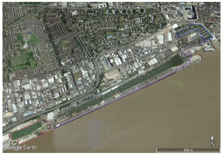
A downloadable app allows users to screen AR and hear testimony on their smartphone when they move through interactive sites, tracked by GPS. Within these sites (figure 1) there will be ‘interactive zones’, whereby the app will play an alert prompting the individual to stop and observe an AR-generated, 360-degree view of the past, overlaying the present. They can also interact with personal testimonies in these zones, through interaction with characters. There is no formal order to exploration, nor do the sites have to be visited in one day, meaning greater freedom for the user. As the landscapes contain hazards, such as open water and uneven ground, the experience must be limited to ‘interactive zones’ to protect the individual. However, this allows the participant to become more engrossed in the present landscape as they explore the sites to locate ‘zones’.
Designated Sites:
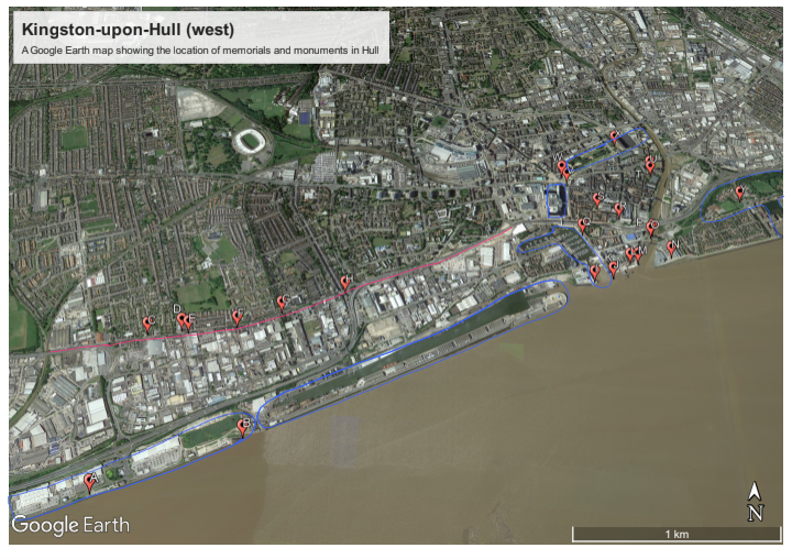
Site A: St Andrew’s Dock (Figure 1: red) Site B: Public footpath connecting sites A and C (Figure 1: purple) Site C: Hull Marina (Figure 1: blue)
Figure 1: A map showing the three sites of the Hull Docklands: Heritage Trail, 2024, screenshot, https://earth.google.com.
Aims:
Allow interaction with Hull’s maritime heritage.
Explore a diverse range of testimony, expanding beyond the typical ‘trawlerman viewpoint’.
Use AR to encourage exploration of the landscape and visible remnants of the past.
Consider the communities built by past and present maritime activity.
Target Audience:
The experience is primarily for adults who want to learn and interact with the city’s maritime heritage. Due to the hazardous nature of the sites, the experience cannot be recommended for children.
Technology:
The app, when opened in an ‘interactive zone’, will display an artist’s realistic interpretation of the historic landscape imposed onto the present. The docklands were well photographed during the twentieth century and, as such, will be used for reference. GPS alerts participants when they enter an ‘interactive zone’ and prompts the displayed picture to change as they move their phone.
Acts and Elements –
Act 0: Site A, B, or C
Plot Time – Present day
Space – The experience will begin Site 1, 2, or 3 – user dependent.
Role – Participants will have already downloaded or will download the app onsite.
Interface – Upon opening the app, users are onboarded with an explanation of the experience and technology, before being encouraged to explore to locate ‘interactive zones’ for an AR experience.
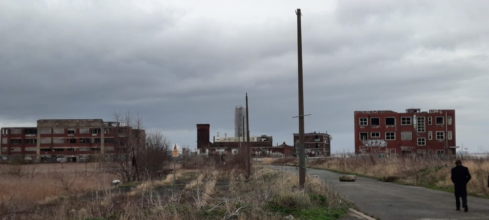
Figure 2: Megan Seeney, St Andrew’s Dock facing east, 2023, digital photograph.
Act 1: Site A – St Andrew’s Dock
Plot Time – Site A explores the post-war period, whereby a boom in the fishing industry in the 1950s and sixties occurred. The 1968 Triple Trawler Tragedy and the Headscarf Revolutionaries will also be discussed in the testimony as important events during the period.
Space – Participants move about St Andrew’s Dock. Within this space multiple, now derelict, dock buildings still stand (although access inside is not possible), as well as the partly filled dock.
Role – Participants explore the site uninhibited by the technology, encouraged to examine points of interest within the landscape. After entering an ‘interactive zone’ they use their phone to explore the digital landscape and interact with characters.
Interface – The user is encouraged to locate ‘interactive zones’, with GPS alerting the individual when entering a zone. Users open the app and can view an accurate interpretation of the historic landscape through an AR lens and interact with nearby characters.
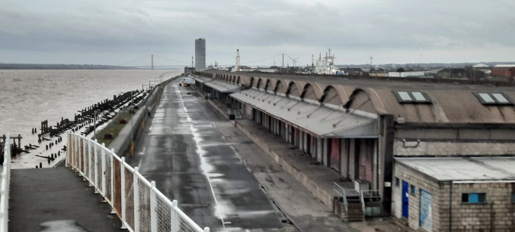
Figure 3: Megan Seeney, Facing west down the Humber with William Wright and Albert Dock to the right side and the Humber Bridge in the background, 2023, digital photograph.
Act 2: Site B – Public footpath alongside William Wright and Albert Docks
Plot Time – Site B explores c.1900 when the landing site along the dock was used to welcome passengers – often migrants from north-western Europe. Accounts from migrants will be re-enacted as part of character interaction for this site.
Space – Participants walk along the bank of the Humber on the footpath, connecting sites A and C. To the north, individuals can see a dock in active use, and south is the Humber estuary.
Role – Participants explore uninhibited by the technology, interacting with points of interest in the landscape. Once users enter an ‘interactive zone’ they use their phone to explore the digital landscape and interact with characters to hear their testimony.
Interface – Users are encouraged to locate ‘interactive zones’, with GPS tracking alerting the individual when they enter a zone. They then open the app to view an accurate interpretation of the historic landscape through an AR lens and interact with nearby characters.
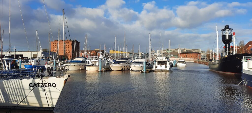
Figure 4: Megan Seeney, Hull Marina with Spurn Lightship to the righthand side of the frame, 2023, digital photograph.
Act 3: Site C – Hull Marina (previously Humber and Railway docks)
Plot Time – Site C explores dock activity c.1850 during its heyday; showcasing the diverse trade which flowed through Hull, including fruit and vegetables, coal, and timber, and the international links this gave the town.
Space – Both Humber and Railway docks are now used for leisure craft. Many original building facades are still visible, plus other clues to the area’s history, such as railway tracks in the cobbled street on the westside.
Role – Participants explore the site uninhibited by the technology, encouraged to examine points of interest. After entering an ‘interactive zone’ they can use their phone to explore the digital landscape and interact with characters to hear testimonies.
Interface – Users are encouraged to locate ‘interactive zones’, with GPS alerting the individual when they enter an area. Opening the app, they can view a realistic interpretation of the historic landscape through an AR lens and interact with nearby characters.
Act 4: Site A, B, or C
Plot Time – Past and present
Space – The experience will end Site 1, 2, or 3 – user dependent.
Role – Participants exit the app and return to their present self.
Interface – No interface is in use after exiting the app.
Heritage and history are not necessarily akin, with heritage efforts generally being more susceptible to agenda, affecting the stories remembered and retold.[1] This is not inherently bad however, with many heritage projects highlighting histories often neglected from the mainstream narrative. Heritage projects can also democratise history by making it more accessible to the ordinary person, and can also help build or maintain community bonds in the present.[2] Most of Hull’s memorials and monuments are located across the western and central dockland, as well as in Old Town (penned in by Queen’s Gardens to the north, the river Hull to the east, Humber to the south, and Princes’ Quay-Hull Marina to the west); with newer heritage projects also appearing down Hessle Road in recent years. Figure 1 is a map displaying the location of all monuments recorded with docks (both in use and historical) highlighted in blue, and Hessle Road highlighted in pink. The legend can be found below, along with the associated digital record.
Figure 1: A Google Earth map showing the location of monuments recorded, 2024, screenshot, https://earth.google.com/.
Whilst, naturally, sculptures of various intention exist outside of these areas in the city, the concentration which exists in regions with strong ties to a maritime history is apparent. This, along with monuments often being dedicated to seafaring – or more specifically fishing – suggests a strong will to centre this narrative in the city’s cultural heritage. As such, studying and recording what causes and events were considered important enough to be remembered through art can illuminate a deeper cultural understanding of the communities that advocated and funded them, as well as the impact history and heritage may have had on societies past and present.
[1] Rodney Harrison, “What is Heritage?” in Understanding the Politics of Heritage, ed. Rodney Harrison (Manchester: Manchester University Press, 2010), 10.
[2] Samuel Raphael, Theatres of Memory: Past and Present in Contemporary Culture (London: Verso, 2012), 152.
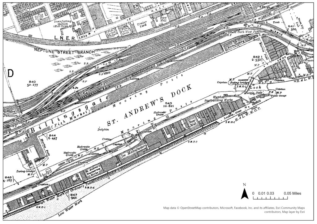
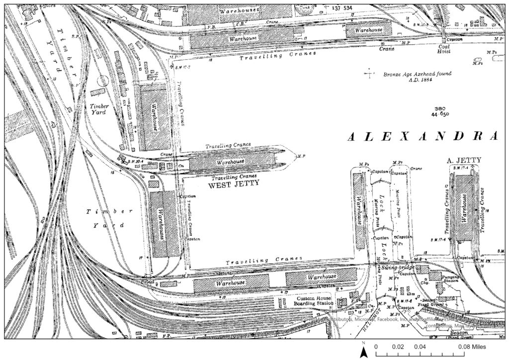
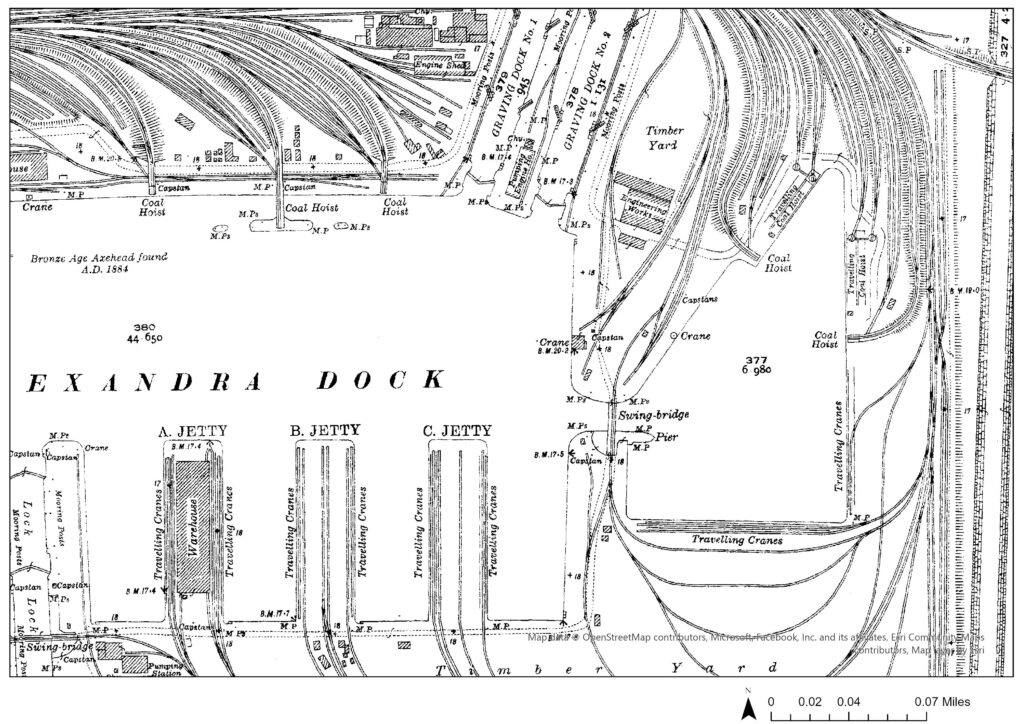
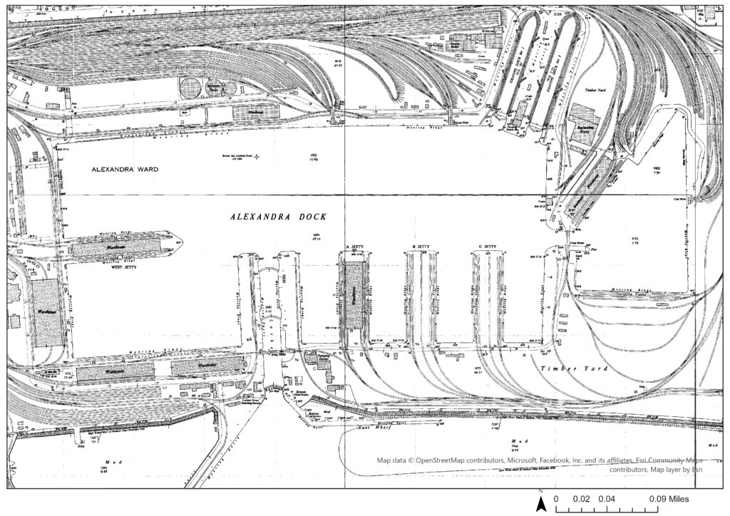
Within Hull’s heritage, that being the history actively remembered and considered culturally valuable by the community, the fishing industry is typically championed.[1] One visual iteration of this is the number of memorials and monuments across the city dedicated to trawlermen and the wider fishing community. Heavy casualties amongst fishermen naturally left remnant feelings of loss and sacrifice, which increased its significance in terms of heritage. A more varied maritime history, however, brought prosperity and status to the port of Hull but is seldom regarded with the same importance. For comparison, St Andrew’s Dock and Alexandra Dock were both built in the 1880s, with the former dedicated to landing fish and the latter holding more varied trade, including timber and coal.[2] Alexandra Dock (Figures: 2&3) had significantly more investment in infrastructure than St Andrew’s (Figure: 1), as can be seen through the disparity in dockside technology such as number of cranes and railway lines, suggesting it was more prosperous.
Figure 1: Megan Seeney, “St Andrew’s Dock, 1920s”, JPEG map, Scale 1:2500, 1:2500 County Series 2nd Revision, 1 January 1928, ArcGIS, using Digimap County Series 1:2500 (1853-1951) Collection, https://digimap.edina.ac.uk/, created 15 January 2024.Figure 2: Megan Seeney, “Alexandra Dock (Westside), 1920s”, JPEG map, Scale 1:2500, 1:2500 County Series 2nd Revision, 1 January 1928, ArcGIS, using Digimap County Series 1:2500 (1853-1951) Collection, https://digimap.edina.ac.uk/, created 15 January 2024.Figure 3: Megan Seeney, “Alexandra Dock (Eastside), 1920s”, JPEG map, Scale 1:2500, 1:2500 County Series 2nd Revision, 1 January 1928, ArcGIS, using Digimap County Series 1:2500 (1853-1951) Collection, https://digimap.edina.ac.uk/, created 15 January 2024.
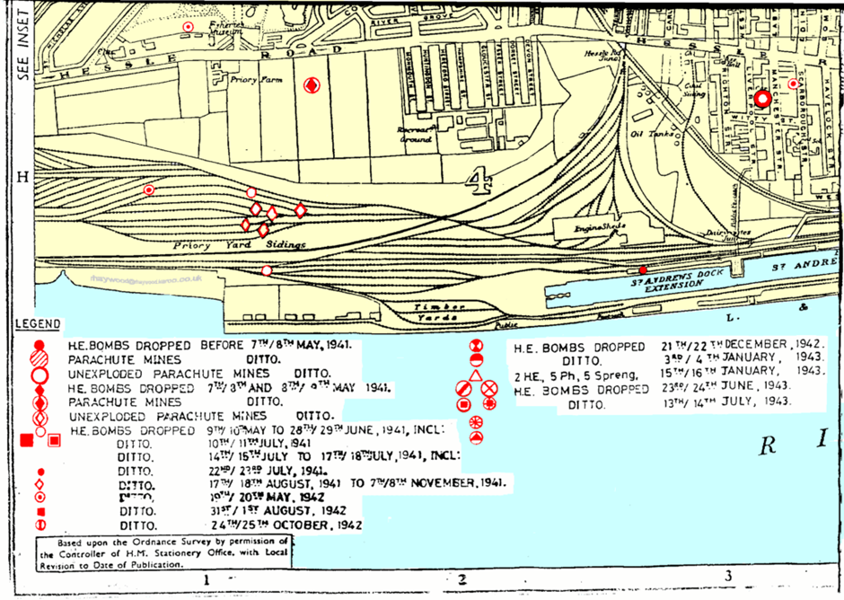
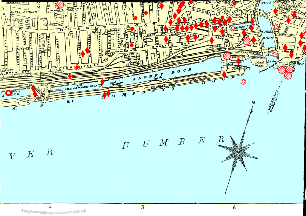
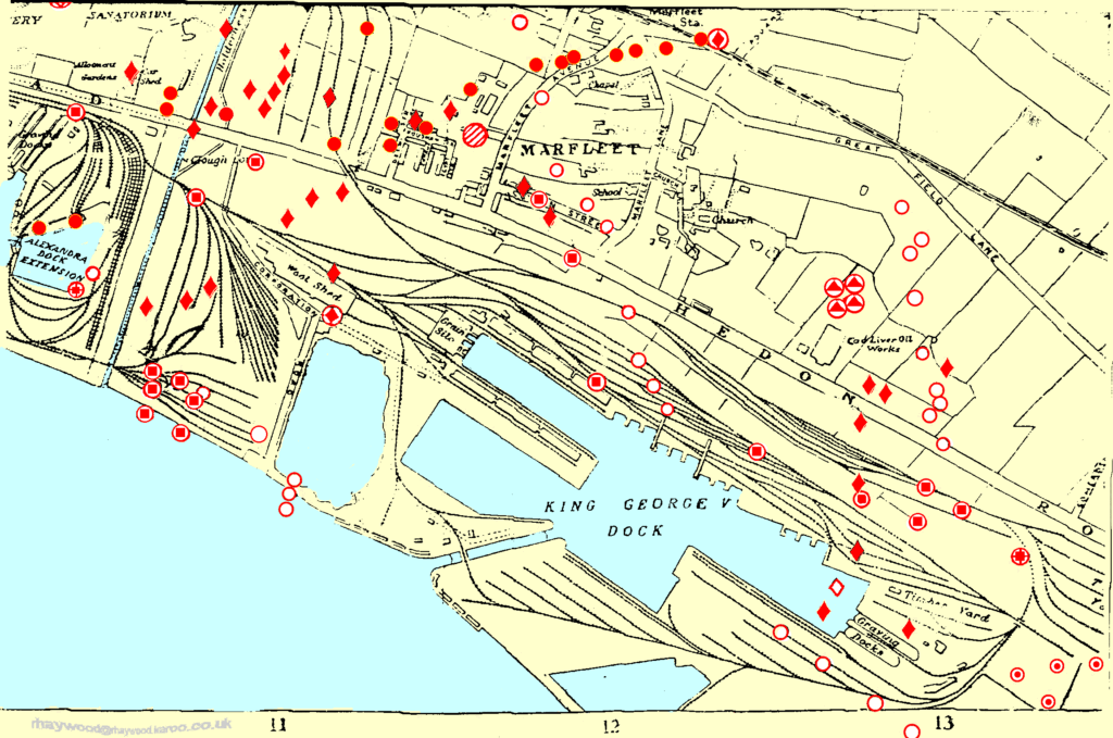
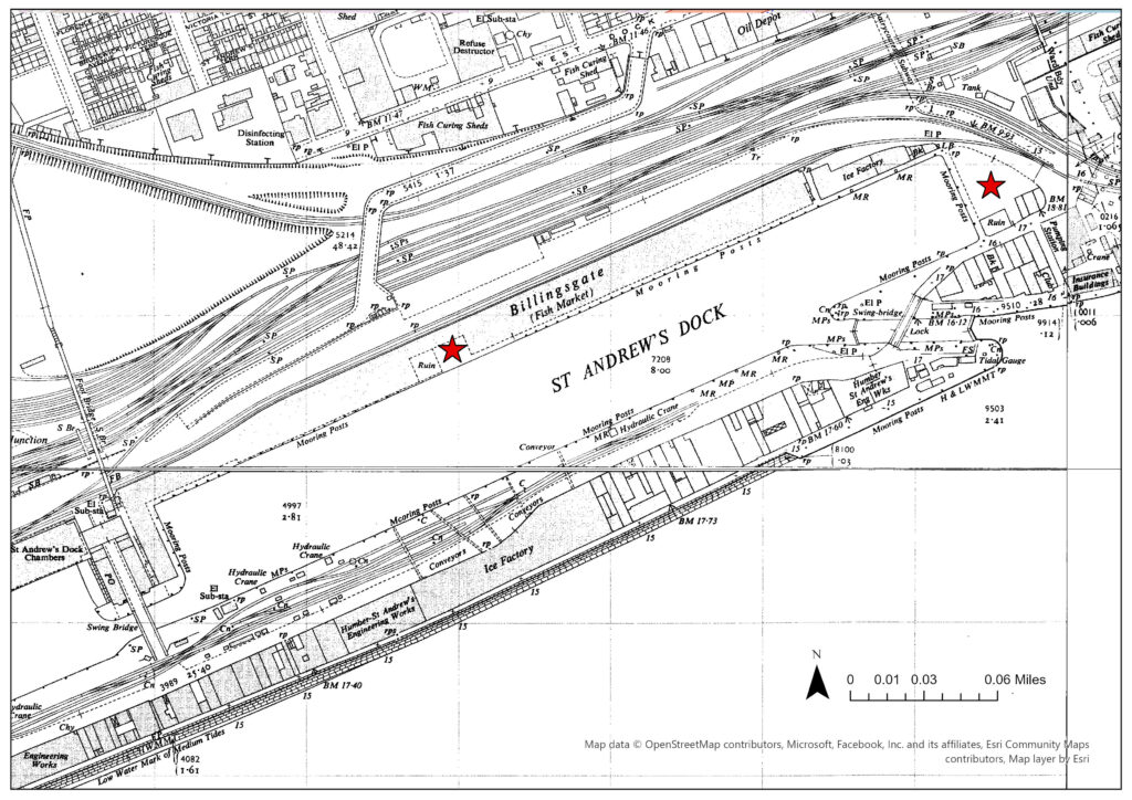
Further to this, considering the docks were strategic targets for Axis bombing campaigns during WWII, Alexandra Dock was much more heavily affected than St Andrew’s. Figures 4-7 show the locations of all High-explosive and Parachute Mines dropped on the city.[3] Alexandra had upward of twenty-five direct hits, with many more in proximity (Figures: 6&7), compared to just four on St Andrew’s and its extension (Figures: 4&5). As such the trade activity of Alexandra Dock was inferably of larger importance than that of St Andrew’s, and thus a more significant target for bombers, as its coal and timber, for example, were vital to continuing domestic industry and the wider Allied war effort. Moreover, Figure 9 (when compared with Figures: 2&3) shows all but the warehousing on the northwest corner of Alexandra Dock was rebuilt in the decade after the war, compared to St Andrew’s where the three areas hit by bombs on the main dock were still labelled as ‘ruin’ (see stars on Figure 8) indicating a lack of investment in rebuilding efforts.
Figure 4: Rob Haywood, The Hull Blitz, 2021, Tile 13, 5.5 inches:1 mile scale, http://www.rhaywood.karoo.net/pics/maps/13.gif.Figure 5: Rob Haywood, The Hull Blitz, 2021, Tile 14, 5.5 inches:1 mile scale, http://www.rhaywood.karoo.net/pics/maps/14.gif.Figure 6: Rob Haywood, The Hull Blitz, 2021, Tile 15, 5.5 inches:1 mile scale, http://www.rhaywood.karoo.net/pics/maps/15.gif.Figure 7: Rob Haywood, The Hull Blitz, 2021, Tile 16, 5.5 inches:1 mile scale, http://www.rhaywood.karoo.net/pics/maps/16.gif.Figure 8: Megan Seeney, “St Andrew’s Dock, 1950s – labelled”, JPEG map, Scale 1:2500, 1st Edition (1943-1995) National Grid 1:2500, 1 January 1950 and 1 January 1951, ArcGIS, using Digimap National Grid 1:2500 (1943-1995) Collection, https://digimap.edina.ac.uk/, created 15 January 2024.Figure 9: Megan Seeney, “Alexandra Dock, 1950s”, JPEG map, Scale 1:3500, 1st Edition (1943-1995) National Grid 1:2500, 1 January 1951 and 1 January 1953, ArcGIS, using Digimap National Grid 1:2500 (1943-1995) Collection, https://digimap.edina.ac.uk/, created 15 January 2024.
[1] Rodney Harrison, “What is Heritage?” in Understanding the Politics of Heritage, ed. Rodney Harrison (Manchester: Manchester University Press, 2010), 9.
[2] David Gerrard, A Century of Hull: Events, People and Places over the 20th Century (Stroud: The History Press, 2009), 13.
[3] Rob Haywood, “The Hull Blitz: A Bombing Map,” RHaywood, accessed on 3 January 2024, http://www.rhaywood.karoo.net/bombmap.htm. Originally plotted c.1945 but digitised by Haywood, a local historian. Incendiary bombs were not included. Points referenced in Map Analysis were cross-referenced with Nick Cooper, City on Fire: Kingston upon Hull 1939-45 (Stroud: Amberley Publishing, 2017), 81-88.
Mini Project 1: Image Interpretation using Google Earth
The use of aerial photography for archaeological image interpretation is not a new technique, with the 1906 Stonehenge exploration via army balloon thought to be the earliest example in England.[1] However a significant improvement in the technologies available has expanded the potential benefits of such methods.[2] The approach can now assist archaeologists in effectively monitoring Scheduled Monuments, allowing subtle changes overtime to be detected.[3] Aerial and satellite image interpretation also allows researchers to identify sites of potential interest quicker, and over a wider area, compared to ground visits alone. This is particularly useful when the landscape is at risk of disturbance and protected status must be allocated quickly.[4]
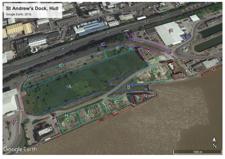
Taking the example of St Andrew’s Dock, Hull – which closed in 1975 and has seen no redevelopment since – satellite imagery reveals the clearly defined shape of the old dock (Figure 1: A), lock (Figure 1: B), and bullnose (Figure 1: N), as well as a disused road which serviced the quay (Figure 1: C). Further, the position of the derelict buildings remaining (Figure 1: K – N) can be understood better relative to the wider landscape they were originally constructed amongst, especially as the outlines of now demolished buildings can still be observed (Figure 1: D – J).
Figure 1: A map from Google Earth (satellite, 2018) showing St Andrew’s Dock – edited, 2023, screenshot, https://earth.google.com.
Legend (for Figure 1):
A – St Andrew’s Dock B – Two sets of lock gates (though only one set remains intact) towards St Andrew’s Dock C – North Road including a subway tunnel north, originally towards Hessle Road connected via Subway Street. D – Billingsgate Fish Market E – Ice Factory F – J. Marr & Son Ltd., seafoods G – Various smaller building/units, including a bank and a working man’s club when the dock closed in the 1970s.
H – Various smaller dock buildings/units I – Various smaller dock buildings/units J – Humber-St Andrew’s Engineering Works K – Lord Line, shipping office L – Hydraulic Pump House M – Globe Engineering, insurance building N – Dock building O – Jetty P – Jetty Q – St Andrew’s Quay Retail Park R – Cranswick plc.
The imagery was analysed for any visible defined shapes, and areas of differing colour or texture, which can indicate the remnants of a manmade structure (as seen in Figure 1: C – J). After the sites of interest were identified, historic GIS Ordnance Survey maps (such as those utilised in Map Analysis) were used alongside twentieth century photography, including that in Fish Dock, to assign function to the structures.[5] In the case of St Andrew’s, where the recent history is fairly well documented, the use of image interpretation can still provide unique insights. For instance, the dimensions of now demolished buildings can be taken and historical photography may be better attributed to its exact position, allowing a fuller understanding of the history of the dockland to be had.
[1] Robert H. Bewley, “Aerial Survey for Archaeology,” Photogrammetric Record 18 (2003): 274.
[4] Louise Rayne, et al., “From Above and on the Ground: Geospatial Methods for Recording Endangered Archaeology in the Middle East and North Africa,” Geosciences 7 (2017): 111.
[5] Michael Thompson, Fish Dock: The Story of St. Andrew’s Dock Hull (Beverley: Hutton Press, 1989).