Watchtower, Hull Citadel

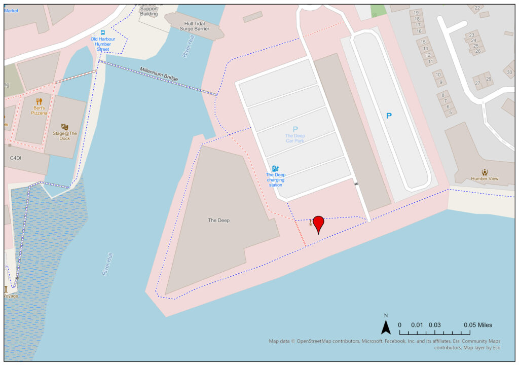
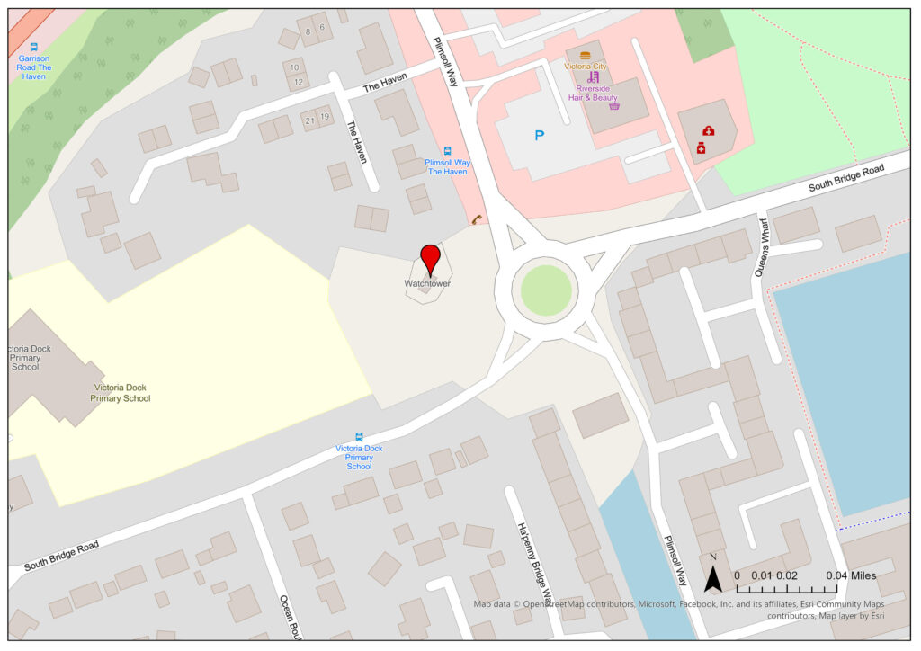
Statutory Address: 10 The Haven, Hull, HU9 1TH

Coordinates: 53°44’32″N 0°19’20″W


Figure 1: Megan Seeney, Hull Citadel Watchtower, Victoria Dock, Hull, 2023, digital photograph.
Figure 2: Megan Seeney, Side-view of Hull Citadel Watchtower, Victoria Dock, Hull, 2023, digital photograph.
Figure 3: Megan Seeney, A close-up of the blue plaque associated with Hull Citadel Watchtower, Victoria Dock, Hull, 2023, digital photograph.

Description of Location –

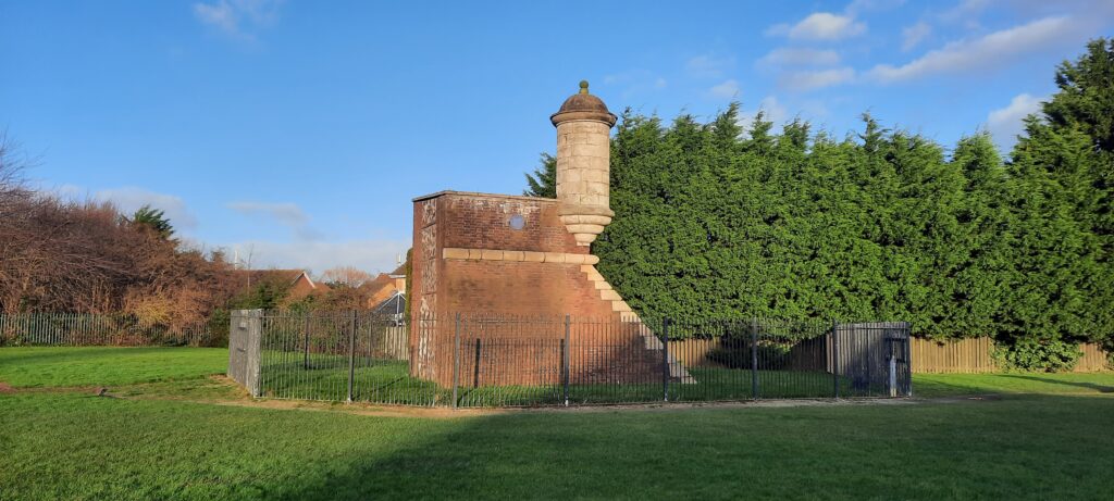
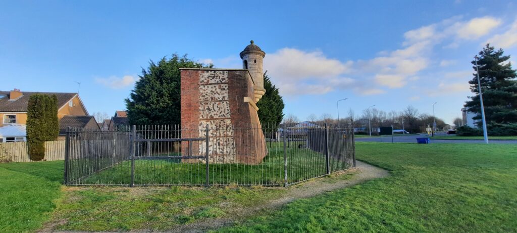
The reconstructed watchtower is located on Victoria Dock village. It is redeveloped land which previously held Victoria Dock, 1850-1987, and Hull Citadel (completed in c.1690-1864) before that.

Figure 4: Megan Seeney, “Watchtower, Hull Citadel”, JPEG map, Scale 1:2000, Open Street Map, December 2023, ArcGIS, created 15 January 2024.

Details –

Erected: c.1690, moved to East Park, Holderness Road in 1912 and its current location in 1990.

Listed: The buried remains under part of Victoria Dock, including the site of the reconstructed watchtower, are listed as a Scheduled Monument

Monument Type: Historical Interest

Associated Site(s): Not applicable

Inscription(s): “2003. This 17th century watchtower marks the east point of Hull Citadel built 1681-90. The citadel was a massive triangular fort incorporating earlier defences alongside the river Hull. It was levelled in 1863-64. Hull Civic Society.”

There is also an information board attached to the site, a picture of which can be found below:

Figure 4: Megan Seeney, A photograph of the information board associated with Hull Citadel Watchtower, Victoria Dock, Hull, 2023, digital photograph.

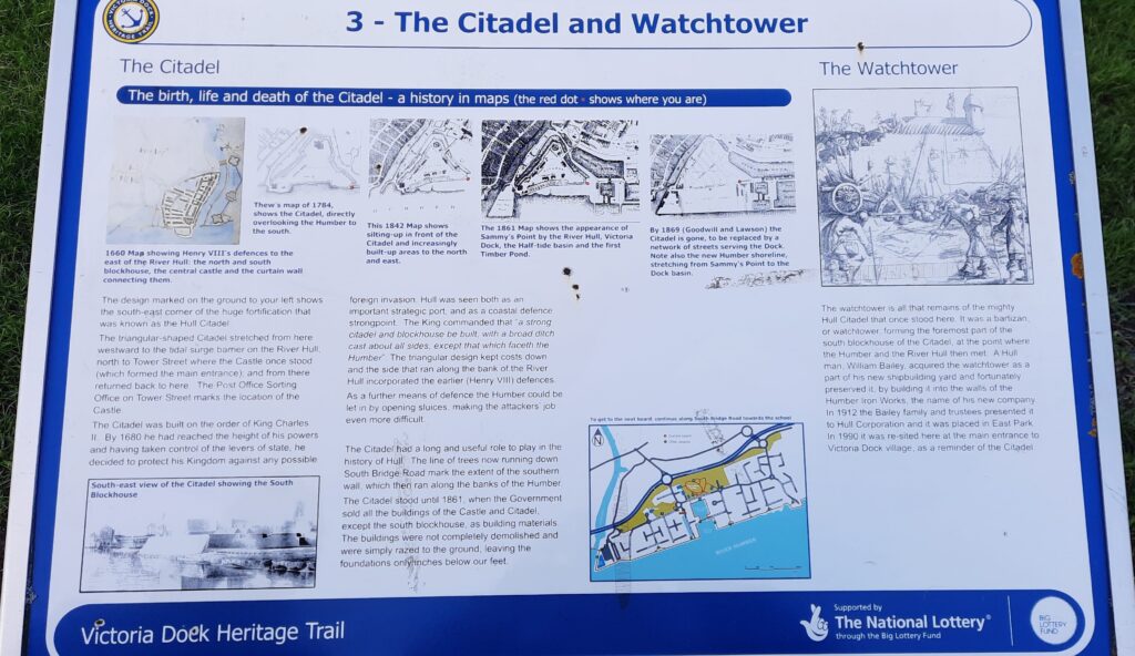
Description: The citadel watchtower consists of a white cylindrical tower jutting out over a corner section of red brick wall with white stone detailing. There is a blue plaque fixed to the side of the watchtower. The citadel was constructed on the order of Charles II in 1680, although an earlier curtain wall defence along the east bank of the river Hull, constructed by Henry VIII, was included in the later citadel design. Hull was considered both an important port for trade and a coastal strongpoint defensively as to receive royal military attention.

Additional Resources –

“Hull Castle, South Blockhouse and Part of Late 17th Century Hull Citadel Fort at Garrison Site,” Historic England, 16 March 1972, https://historicengland.org.uk/listing/the-list/list-entry/1020426?section=official-list-entry.

Audrey Howes and Martin Foreman, Town and Gun: The 17th-century Defences of Hull (Kingston upon Hull: Kingston Press, 1999).

Colin McNicol, “The History of Victoria Dock,” Victoria Dock Village Hall and Community Centre, accessed 1 January 2024, https://www.vdvh.co.uk/the-history-of-victoria-dock.

David Neave and Susan Neave, “The Merchants’ Golden Age, 1650-1775,” in Hull: Culture, History, Place, ed. David J. Starkey et al. (Liverpool: Liverpool University Press, 2017), 90-92.

English Heritage, East Park – Registered Park (London: English Heritage, 20 April 2001), accessed 1 January 2024, https://www.hull.gov.uk/downloads/file/1440/east-park.

William Wilberforce Statue, Wilberforce House

Statutory Address: Wilberforce House, 23-25 High Street, Hull, HU1 1NQ

Coordinates: 53°44’39″N 0°19’48″W


Figure 1: Megan Seeney, William Wilberforce Statue, Wilberforce House, Hull, 2023, digital photograph.
Figure 2: Megan Seeney, A close-up of the inscription on the William Wilberforce Statue, Wilberforce House, Hull, 2023, digital photograph.

Description of Location –

The statue is located in the front garden of Wilberforce House (Grade I listed), a museum dedicated to the Transatlantic Slave trade and the abolitionist movement.

Figure 3: Megan Seeney, “William Wilberforce Statue, Wilberforce House”, JPEG map, Scale 1:1000, Open Street Map, December 2023, ArcGIS, created 15 January 2024.

Details –

Erected: c.1884

Listed: Grade II listed

Monument Type: Historical Interest

Associated Site(s): The Mahatma Gandhi statue is also located on the Museum Quarter site.

Inscription(s): “Presented to the corporation by Henry Briggs Esquire ? Sheriff of Kingston-Upon-Hull ?”

“William Wilberforce. Born in Hull 24 August 1759. Died in London 29 July 1833. Member of Parliament for Hull from 1780 to 1784. Member of Parliament for Yorkshire from 1784 to 1812. England owes to him the Reformation of Manners, the world owes to him the Abolition of Slavery.”

Description: A white stone, life-sized statue of William Wilberforce (1759-1833) leaning on a short column to his left-hand side, upon an inscribed pink stone pedestal. The statue was probably erected on the fiftieth anniversary of Wilberforce’s death. William D Keyworth Jnr (1843-1902) designed the statue and was a well-respected sculptor who was born in Hull.

Additional Resources –

“Statue of William Wilberforce, Kingston upon Hull,” Historic England, accessed 1 January 2024, https://historicengland.org.uk/services-skills/education/educational-images/statue-of-william-wilberforce-8666.

“Statue of William Wilberforce in Garden of Wilberforce House,” Historic England, 21 January 1994, https://historicengland.org.uk/listing/the-list/list-entry/1197754.

Gerardine Mulcahy-Parker. “Keyworth, William Day, junior.” Oxford Dictionary of National Biography, 6 October 2016. https://www-oxforddnb-com.libproxy.ncl.ac.uk/display/10.1093/ref:odnb/9780198614128.001.0001/odnb-9780198614128-e-110203?rskey=OMQMlP&result=2.

John Wolffe. “Wilberforce, William.” Oxford Dictionary of National Biography, 23 September 2004. https://www.oxforddnb.com/display/10.1093/ref:odnb/9780198614128.001.0001/odnb-9780198614128-e-29386.

St Andrew Mural, Hessle Road

Statutory Address: Fotoworx, 159 Hessle Road, Hull, HU3 2AF

Coordinates: 53°44’11″N 0°21’27″W


Figure 1: Megan Seeney, Fishing Heritage Mural, Hessle Road, Hull, 2023, digital photograph.

Description of Location –

The mural is located at the eastern end of the Hessle Road shopping district, facing onto the Daltry Street roundabout – one of the main routes into the city.

Figure 2: Megan Seeney, “St Andrew’s Mural, Hessle Road”, JPEG map, Scale 1:1000, Open Street Map, December 2023, ArcGIS, created 15 January 2024.

Details –

Erected: Unknown

Listed: Not listed

Monument Type: Mural

Associated Site(s): There are multiple murals located down Hessle Road including the Hessle Road Fisherman mural (Halfway Hotel), Three Fishing Scenes mural (Turbo Systems), Headscarf Revolutionaries mural (Dixons Bakery), and Fishing Industry mural (Fe’male Ego).

Inscription(s): “St Andrews Ward. Welcome to Hessle Road home of the fishing heritage”

“Hull City Council”

Description: The brightly coloured mural consists of a St Andrew, patron saint of fishermen, standing behind a young man, guiding him as he steers a ship’s wheel amongst an apparently stormy sea in the background.

Additional Resources –

Not applicable

Russian Outrage Memorial

Statutory Address: St Barnabas Court, Hessle Road, Hull, HU3 4BE

Coordinates: 53°44’07″N 0°21’46″W


Figure 1: Megan Seeney, Russian Outrage Memorial, Hessle Road, Hull, 2023, digital photograph.
Figure 2: Megan Seeney, A close-up of the Russian Outrage Memorial inscription, Hessle Road, Hull, 2023, digital photograph.

Description of Location –

The memorial is located on the Hessle Road-Boulevard crossroad junction, opposite the Hull Fishing Heritage Centre. Hessle Road was the traditional home of much of Hull’s fishing community due to its close proximity to the docks, particularly St Andrews (‘Fish Dock’).

Figure 3: Megan Seeney, “Russian Outrage Memorial”, JPEG map, Scale 1:1000, Open Street Map, December 2023, ArcGIS, created 15 January 2024.

Details –

Erected: 1906

Listed: Grade II Listed

Monument Type: Memorial

Associated Site(s): Not applicable

Inscription(s): “Unveiled by Lord Nunburnholme August 30th 1906”

“Albert Leake sculptor Hull”

“R.A.O.B. Erected by public subscription to the memory of George Henry Smith (Skipper) and William Richard Leggett (Third Hand) of the ill fated trawler “Crane” who lost their lives in the North Sea by the action of the Russian Baltic Fleet October 22nd 1904 and Walter Whelpton (Skipper) of the trawler “Mind” who died from shock May 13th 1905.”

Description: A stone statue of a fisherman with his left arm reaching upwards to the sky and holding a pair of binoculars in his right. Situated upon an inscribed pink stone pedestal (a reference to the R.A.O.B is included as Skipper George Smith was a member). It is a memorial to the men who lost their lives during the Russian Outrage (or North Sea Incident) whereby inexperienced sailors in the Russian navy mistook a group of trawlers from Hull fishing off Dogger Bank as Japanese torpedo boats during the Russo-Japanese War (1904-1905). There was an outpouring of grief both nationally and from the Hessle Road community after the incident, with a mile long procession being held in Hull.  

Additional Resources –

“Fishermen’s Memorial at Junction with Boulevard,” Historic England, 21 January 1994, https://historicengland.org.uk/listing/the-list/list-entry/1197743.

“The Russian Outrage: The Aftermath,” Hull Museums Collection, accessed 1 January 2023, http://museumcollections.hullcc.gov.uk/collections/theme.php?irn=1072.

“The Russian Outrage: Under Attack,” Hull Museums Collection, accessed 1 January 2023, http://museumcollections.hullcc.gov.uk/collections/storydetail.php?irn=1071.

Alec Gill, Hull’s Fishing Heritage: Aspects of Life in the Hessle Road Fishing Community (Barnsley: Wharncliffe Books, 2003), 43.

British Trawlers Shelled by Russians, (1905, United Kingdom: British Pathé), available at https://www.britishpathe.com/asset/196879/.

The Board of Trade, North Sea Incident: (21-22 October 1904) (London: Wyman & Sons Ltd., 1905), accessed 1 January 2023, https://babel.hathitrust.org/cgi/pt?id=hvd.32044103232666&seq=5.

Fishing Industry Mural, Hessle Road

Statutory Address: Fe’Male Ego Hair and Beauty Salon, 321-323 Hessle Road, Hull, HU3 4BJ

Coordinates: 53°44’04″N 0°21’59″W


Figure 1: Megan Seeney, Fishing Industry mural, Hessle Road, Hull, 2023, digital photograph.

Description of Location –

The mural is located on the side wall of Fe’Male Ego Salon just off Hessle Road on West Dock Avenue, opposite The Rayners pub – a traditionally popular pub with the local fishing community.

Figure 2: Megan Seeney, “Fishing Industry Mural, Hessle Road”, JPEG map, Scale 1:1000, Open Street Map, December 2023, ArcGIS, created 15 January 2024.

Details –

Erected: 2017

Listed: Not listed

Monument Type: Mural

Associated Site(s): There are multiple murals located down Hessle Road including the Hessle Road Fisherman mural (Halfway Hotel), Three Fishing Scenes mural (Turbo Systems), Headscarf Revolutionaries mural (Dixons Bakery), and Fishing Heritage mural (Fotoworx).

Inscription(s): “WAISTELLS”

“The Hull Bullnose Heritage Group”

“Boulevard Academy”

“Eastfield Primary School”

Description: A black and white mural depicting various characters and iconography of the mid-twentieth century fishing industry, including a fisherman in waterproofs holding a fish alongside a boy and framed by a trawler and an anchor, and one of Hessle Road’s most famous landladies Flo Hemingway, who used to manage the Rayners pub. The site used to house Waistells, a tailors where many fishermen would purchase suits when they returned from a fishing trip. The mural was painted by artist Keith Holmes.

Additional Resources –

“Leisure Activities and Fashion,” St. Andrews Dock Heritage Park Action Group, accessed 1 January 2024, https://www.hullfishingheritage.org.uk/3145-2/.

James Campbell, “Sites for Three More Stunning Hessle Road Murals Revealed,” Hull Daily Mail, 15 August 2017, https://www.hulldailymail.co.uk/whats-on/sites-tree-more-stunning-hessle-327382.

James Campbell, “Work Starts on the Latest Stunning Hessle Road Mural,” Hull Daily Mail, 12 September 2017, https://www.hulldailymail.co.uk/news/hull-east-yorkshire-news/work-starts-latest-stunning-hessle-464432.

Jess Molyneux, “Fascinating Photos Capture Life in Hull’s Landmark Rayners Pub in 1980s,” Hull Daily Mail, 7 August 2022, https://www.hulldailymail.co.uk/news/history/gallery/fascinating-photos-capture-life-hulls-7415288.

Headscarf Revolutionaries Mural, Hessle Road

Statutory Address: 436 Hessle Road, Hull, HU3 3SE

Coordinates: 53°44’03″N 0°22’16″W


Figure 1: Megan Seeney, The Headscarf Revolutionaries mural, Hessle Road, Hull, 2023, digital photograph.

Description of Location –

The mural is located on the side wall of Dixons Bakery, towards Wynsors World of Shoes, on Hessle Road which was the traditional home of much of Hull’s fishing community due to its close proximity to the docks, particularly St Andrews (‘Fish Dock’).

Figure 2: Megan Seeney, “Headscarf Revolutionaries Mural”, JPEG map, Scale 1:1000, Open Street Map, December 2023, ArcGIS, created 15 January 2024.

Details –

Erected: Unknown

Listed: Not listed

Monument Type: Mural

Associated Site(s): There are multiple murals located down Hessle Road including the Hessle Road Fisherman mural (Halfway Hotel), Three Fishing Scenes mural (Turbo Systems), Fishing Industry mural (Fe’male Ego), and Fishing Heritage mural (Fotoworx).

Inscription(s): “The Hull Bullnose Heritage Group”

[The bottom of the mural has been signed by the family members of the four women depicted]

Description: The mural depicts the four women who led the Headscarf Revolutionaries in black and white: Lillian Bilocca, Yvonne Blenkinsop, Christine Jensen (Smallbone), and Mary Denness. The women campaigned for changes to fishing practices which would make the industry safer, prompted by the Triple Trawler Tragedy in 1968.

Additional Resources –

“Hull’s ‘Headscarf Revolutionary’ Yvonne Blenkinsop Dies,” BBC, 24 April 2022, https://www.bbc.co.uk/news/uk-england-humber-61207930.

Brian W. Lavery, “Bilocca [née Marshall], Lillian [Lil],” Oxford Dictionary of National Biography, 30 May 2013, https://www.oxforddnb.com/display/10.1093/ref:odnb/9780198614128.001.0001/odnb-9780198614128-e-72725?rskey=fVnFBp&result=1.

Emily Johnson, “Hull’s Fishing Community Unites to Remember Victims of the Triple Trawler Tragedy,” Hull Daily Mail, 11 January 2023, https://www.hulldailymail.co.uk/news/hull-east-yorkshire-news/gallery/hulls-fishing-community-unites-remember-8018306.

Hull’s Headscarf Heroes, directed by Steve Humphries (2018, United Kingdom: BBC Four), available at https://learningonscreen.ac.uk/ondemand/index.php/prog/10A39B55?bcast=131904503.

.

Three Fishing Scenes Mural, Hessle Road

Statutory Address: Turbo Systems, 1 Gillett Street, Hull, HU3 4JA

Coordinates: 53°44’03″N 0°22’14″W


Figure 1: Megan Seeney, Three Fishing Scenes mural, Hessle Road, Hull, 2023, digital photograph.

Description of Location –

The mural is located on the Hessle Road facing side of the Turbo Systems site. Hessle Road used to house much of Hull’s fishing community due to its close proximity to the docks, particularly St Andrews (‘Fish Dock’).

Figure 2: Megan Seeney, “Three Fishing Scenes Mural”, JPEG map, Scale 1:1000, Open Street Map, December 2023, ArcGIS, created 15 January 2024.

Details –

Erected: Unknown

Listed: Not listed

Monument Type: Mural

Associated Site(s): There are multiple murals located down Hessle Road including the Hessle Road Fisherman mural (Halfway Hotel), Headscarf Revolutionaries mural (Dixons Bakery), Fishing Industry mural (Fe’male Ego), and Fishing Heritage mural (Fotoworx).

Inscription(s): Not applicable

Description: There are three separate fishing scenes combined into one large, colourful mural, depicting the lives of the community who lived and worked in the Hessle Road area of Hull when fishing was still a major industry in the city (prior to c. 1970s). The leftmost image is of two women mending fishing nets, the central panel depicts four women in headscarves talking together in front of a ship (perhaps a tribute to the Headscarf Revolutionaries), and the right image is of men working on ships and the dockside hauling fish, with a couple of children sat observing.

Additional Resources –

Not applicable

Hessle Road Fisherman Mural

Statutory Address: The Halfway Hotel, Hessle Road, Hull, HU3 5AA

Coordinates: 53°44’02″N 0°22’26″W


Figure 1: Megan Seeney, Hessle Road Fisherman Mural, The Halfway Hotel, Hull, 2023, digital photograph.

Description of Location –

The large mural is painted on the side of the Halfway Hotel pub down Hessle Road which used to house much of Hull’s fishing community due to its close proximity to the western docks, particularly St Andrews (‘Fish Dock’).

Figure 2: Megan Seeney, “Hessle Road, Fisherman Mural”, JPEG map, Scale 1:1000, Open Street Map, December 2023, ArcGIS, created 15 January 2024.

Details –

Erected: 2017

Listed: Not listed

Monument Type: Mural

Associated Site(s): There are multiple murals located down Hessle Road including the Three Fishing Scenes mural (Turbo Systems), Headscarf Revolutionaries mural (Dixons Bakery), Fishing Industry mural (Fe’male Ego), and Fishing Heritage mural (Fotoworx).

Inscription(s): Not applicable

Description: A brightly coloured mural depicting a fisherman, in yellow waterproof raincoat and hat, with a net on St Andrews Dock alongside a trawler. It was created during Hull’s year as City of Culture as a part of the Roots and Routes celebration.

Additional Resources –

“Hull’s Maritime Landmarks,” Maritime Hull, 2 March 2021, https://maritimehull.co.uk/whats-happening/blogs/hulls-maritime-landmarks.

Joshua Rogerson, “Hull City of Colour: A Guide to the City’s Vibrant Outdoor Art,” Hull: What’s On, 10 August 2021, https://hullwhatson.com/hull-vibrant-outdoor-art/.

Grey Reef Shark Sculpture

Statutory Address: The Deep, Tower Street, Hull, HU1 4DP

Coordinates: 53°44’19″N 0°19’46″W


Figure 1: Megan Seeney, Grey Reef Shark sculpture, The Deep, Hull, with the tidal barrier in the background, 2023, digital photograph.
Figure 2: Megan Seeney, Grey Reef Shark sculpture, The Deep, Hull, 2023, digital photograph.
Figure 3: Megan Seeney, Close-up of the information plaque on the Grey Reef Shark sculpture, The Deep, Hull, 2023, digital photograph.

Description of Location –

The sculpture is located at the south end of The Deep’s carpark, facing out into the river Humber.

Figure 4: Megan Seeney, “Grey Reef Shark”, JPEG map, Scale 1:2000, Open Street Map, December 2023, ArcGIS, created 15 January 2024.

Details –

Erected: Unknown

Listed: Not listed

Monument Type: Art sculpture

Associated Site(s): Not applicable

Inscription(s): “The Grey Reef Shark. Carcharhinus Amblyrhynchos. One of the family of Requiem sharks (Red Sea to Central Western Pacific). 1 ½ times actual adult size. The Deep.”

Description: A large metal sculpture of a shark, supported above a rock plinth by two metal rods, as so the shark appears to be swimming along the bottom of the sea. Comissioned for the visitor attraction, The Deep, from Christopher Kelly.

Additional Resources –

“Shark at The Deep,” Art UK, accessed 1 January 2024, https://artuk.org/discover/artworks/shark-at-the-deep-322978.

“The Grey Reef Shark,” Statues – Hither & Thither, accessed 1 January 2024, https://statues.vanderkrogt.net/object.php?webpage=ST&record=gbyh030.

King William III Statue

Statutory Address: Market Place, Hull, HU1 1RS

Coordinates: 53°44’28″N 0°20’01″W


Figure 1: Megan Seeney, King William III statue, Market Place, Hull, 2023, digital photograph.
Figure 2: Megan Seeney, King William III statue, Market Place, 2023, digital photograph.
Figure 3: Megan Seeney, A close-up of the inscription on the pedestal of King William III statue, Market Place, Hull, 2023, digital photograph.

Description of Location –

The statue of King William of Orange (locally ‘King Billy’) is located on a traffic island in the middle of Market Place, just before the junction with the A63, above some disused public toilets (Grade II listed). Hull Minster is approximately one hundred meters to the northwest of the site.

Figure 4: Megan Seeney, “King William III”, JPEG map, Scale 1:1000, Open Street Map, December 2023, ArcGIS, created 15 January 2024.

Details –

Erected: 1734, refurbished in 1989.

Listed: Grade I listed (along with the flanking lamps)

Monument Type: Historical Interest

Associated Site(s): Not applicable

Inscription(s): “This statue was erected in the year MDCCXXXIV to the memory of King William the Third our great deliverer”

“This statue was refurbished by Hull City Council with the assistance of public donations and a grant from English Heritage and re-erected on the 5th March 1989. Ceremony performed by

Councillor Mrs. M. Smelt
Lord Mayor of Kingston upon Hull Dr. A. Peper
Burgomaster of Rotterdam
Councillor J. Stanley J.P.
Chairman Technical Services Committee
A.B. Wood, Town Clerk and Chief Executive
J.M. Deeming, City Engineer”

Description: The statue consists of a gilded King William III, dressed in classical Roman costume, upon horseback situated on a white stone pedestal. The statue was designed by Peter Scheemakers, with the lamps added in the late nineteenth century by King & Peach of Hull. The original engraving into the stone is located on the front face of the pedestal above a water fountain, whilst a metal plaque stating refurbishment can be found on the back. The statue was erected to celebrate the now defunct local public holiday ‘Town Taking Day’ and Hull’s role in the Glorious Revolution. During William of Orange’s invasion, Hull’s Catholic governor, Lord Langdale, planned to arrest the deputy governor, Captain Lionel Copley, and other Protestant officials to prevent the city falling. However, Copley became aware of the plot and, together with armed soldiers, confronted Langley in Market Place in a bloodless coup and taking Hull for William III – the second time in less than fifty years the city had defied the reigning monarch.

Additional Resources –

“Statue of King William III and Flanking Lamps,” Historic England, 13 October 1952, https://historicengland.org.uk/listing/the-list/list-entry/1197697?section=official-list-entry.

Angus Young, “The Hidden Story behind Hull’s Golden King Billy Statue from Failed Invasions to a Bloodless Coup,” Hull Daily Mail, 14 September 2022, https://www.hulldailymail.co.uk/news/history/hidden-story-king-billy-statue-3869325.

Briony McDonagh, “Rebellious Hull,” in Hull: Culture, History, Place, ed. David J. Starkey et al. (Liverpool: Liverpool University Press: 2017), 63-64.

Ingrid Roscoe. “Scheemakers, Peter Gaspar.” Oxford Dictionary of National Biography, 23 September 2004. https://www.oxforddnb.com/display/10.1093/ref:odnb/9780198614128.001.0001/odnb-9780198614128-e-24801?rskey=Hdcy2E&result=2.