Andrew Marvell Statue

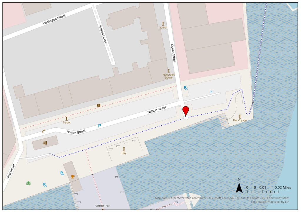
Statutory Address: 711, South Church Side, Hull HU1 1RR

Coordinates: 53°44’30″N 0°20’07″W


Figure 1: Megan Seeney, Andrew Marvell statue, South Church Side, Hull, with the Hands on History Museum in the background, 2023, digital photograph.
Figure 2: Megan Seeney, Andrew Marvell statue, South Church Side, Hull, 2023, digital photograph.
Figure 3: Megan Seeney, A close-up of the inscription on the Andrew Marvell statue, South Church Side, Hull, 2023, digital photograph.

Description of Location –

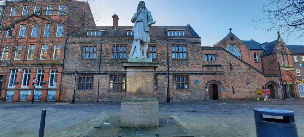
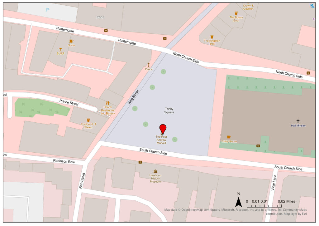
The statue is located in the centre of Trinity Square in front of Hull Minster and the Hands on History Museum (originally Hull Grammar School, founded 1486, with Andrew Marvell and William Wilberforce both being alumni).

Figure 4: Megan Seeney, “Andrew Marvell”, JPEG map, Scale 1:1000, Open Street Map, December 2023, ArcGIS, created 15 January 2024.

Details –

Erected: 1867, originally in the Town Hall. Moved in 1902 to the corner of George Street and Savile Street, then to the corner of Bond Street and George Street in 1922, then to William Gee School in 1963, before being moved to its present location in 1999. The statue’s damaged left hand was also remodelled in 1999.

Listed: Grade II listed

Monument Type: Historical Interest

Associated Site(s): The William de-la-Pole and William Wilberforce (Wilberforce House) statues were all by the same artist, William Day Keyworth junior (1843-1902).

Inscription(s): “The poet Andrew Marvell. An incorruptible patriot, a wise statesman, and a zealous and energetic representative of this his native town in parliament from 1658 to 1678 – Born 1620, died 1678”

“Had we but world
enough and time,
This coyness, lady were
no crime.
We should sit down and
think which way
To walk and pass our
long love’s day;

From To His Coy Mistress by Andrew Marvell”

“Presented by Mr Councillor John Winship to the Corporation of Hull 26th Day of October 1867.”

Description: A white marble statue of the East Yorkshire born poet and politician Andrew Marvell (1621-1678) upon a pink granite plinth. He is wearing seventeenth-century costume. The front of the plinth is inscribed. William D Keyworth Jnr (1843-1902) designed the statue and was a well-respected sculptor who was born in Hull.

Additional Resources –

“Andrew Marvell (1621-1678),” Art UK, accessed 1 January 2024, https://artuk.org/discover/artworks/andrew-marvell-16211678-322979/view_as/grid/search/keyword:andrew-marvell–outdoor_artwork:on/page/1.

“Statue of Andrew Marvell on North Side of South Church Side,” Historic England, 21 January 1994, https://historicengland.org.uk/listing/the-list/list-entry/1197623.

David Gerrard, A Century of Hull: Events, People and Places over the 20th Century (Stroud: The History Press, 2011), 114.

Gerardine Mulcahy-Parker. “Keyworth, William Day, junior.” Oxford Dictionary of National Biography, 6 October 2016. https://www-oxforddnb-com.libproxy.ncl.ac.uk/display/10.1093/ref:odnb/9780198614128.001.0001/odnb-9780198614128-e-110203?rskey=OMQMlP&result=2.

W. H. Kelliher. “Marvell, Andrew.” Oxford Dictionary of National Biography, 23 September 2004. https://www.oxforddnb.com/display/10.1093/ref:odnb/9780198614128.001.0001/odnb-9780198614128-e-18242.

Mahatma Gandhi

Statutory Address: Museum Quarter, High Street, Hull, HU1 1NE

Coordinates: 53°44’38″N 0°19’48″W


Figure 1: Megan Seeney, Bust of Mahatma Gandhi, High Street, Hull, 2023, digital photograph.
Figure 2: Megan Seeney, A close-up of the plaque on the bust of Mahatma Gandhi, High Street, Hull, 2023, digital photograph.

Description of Location –

The statue is located in the Nelson Mandela Ornamental Peace Garden within the Museum Quarter complex.

Figure 3: Megan Seeney, “Mahatma Gandhi”, JPEG map, Scale 1:1000, Open Street Map, December 2023, ArcGIS, created 15 January 2024.

Details –

Erected: 2004

Listed: Not listed

Monument Type: Historical interest

Associated Site(s): The William Wilberforce statue is also located on the Museum Quarter complex.

Inscription(s): “’May noble thoughts come to us from all directions’ Mahatma Gandhi 1869-1948. Unveiled by Rt. Hon. The Lord Puttnam, C.B.E. On the 16th October 2004”

Description: A four-foot-tall bronze bust of the Indian leader Mahatma Gandhi upon a white stone plinth with an engraved metal plaque upon the front. It was sculpted by Mumbaikar Jayprakash Shirgaonkar and was funded by the members Indian community in Hull.

Additional Resources –

“Bust of Mahatma Gandhi Unveiled in Hull’s Mandela Gardens,” MK Gandhi Organisation, accessed 1 January 2024, https://www.mkgandhi.org/newannou/bust_of_gandhi_unveiled.htm.

“Mahatma Gandhi,” Guardian, 31 January 1948, https://www.theguardian.com/world/1948/jan/31/india.fromthearchive1.

Dan Kemp, “The Fascinating Stories behind some of Hull’s Most Famous Statues,” Hull Daily Mail, 17 February 2019, https://www.hulldailymail.co.uk/news/history/famous-statues-fascinating-stories-hull-2546840.

R.A.O.B, St Andrew’s Lock Gates Memorial

Statutory Address: St Andrew’s Dock, Clive Sullivan Way, Hull, HU3 4SA

Coordinates: 53°43’44″N 0°21’55″W


Figure 1: Megan Seeney, St Andrews lock gates memorial, St Andrews Dock, with the River Humber in the background, 2023, digital photograph.
Figure 2: Megan Seeney, A close-up of the memorial stone at St Andrews Dock, Hull, 2023, digital photograph.
Figure 3: Megan Seeney, A close-up of the inscription on the memorial stone, St Andrews Dock, Hull, 2023, digital photograph.
Figure 4: Megan Seeney, A plaque displaying a scene from a fish market, St Andrews Dock, Hull, 2023, digital photograph.
Figure 5: Megan Seeney, A plaque displaying a scene from a fishing dock, St Andrews Dock, Hull, 2023, digital photograph.
Figure 6: Megan Seeney, A plaque displaying a scene from onboard a fishing trawler, St Andrews Dock, Hull, 2023, digital photograph.
Figure 7: Megan Seeney, A plaque displaying a scene with a fishing boat sailing, St Andrews Dock, Hull, 2023, digital photograph.

Description of Location –

The memorial is located on the bullnose of the disused St Andrew’s Dock, near the lock gates on the southwestern side.

Figure 8: Megan Seeney, “R.A.O.B., St Andrew’s Lock Gates Memorial”, JPEG map, Scale 1:5000, Open Street Map, December 2023, ArcGIS, created 15 January 2024.

Details –

Erected: 1993

Listed: Not listed

Monument Type: Memorial

Associated Site(s): Not applicable

Inscription(s): “Royal Antediluvian Order of Buffaloes. St. Andrews Lock Gates 1883-1975. Through these locks passed the ships and men who fished the Arctic grounds of Murmansk, Greenland and Iceland. In 1914 and 1939 men and trawlers went to war. In peace and war this tablet commemorates the many who did not return. R.A.O.B. G.L.E.”

“The Bullnose Memorial Group. Manor Property Group. RAOB.”

“Lost Trawlerman’s Memorial. This memorial was made possible by Mr & Mrs Philip Akrill, The Royal Antediluvian Order of Buffaloes and the families of Hull’s Trawlermen whose loved ones were lost at sea.

‘Wave after wave, each mightier than the last, ‘Til last, a ninth one, gathering half the deep, And full of fishermen’s voices, slowly rose and plunged, Roaring, and all the wave was in flame’. Alfred, Lord Tennyson.”

Photographs of the plaques of inscribed names are included here:

Figure 9: Megan Seeney, A plaque displaying sailors lost at sea from the Port of Hull, St Andrews Dock, beginning George Smith, 2023, digital photograph.
Figure 10: Megan Seeney, A plaque displaying sailors lost at sea from the Port of Hull, St Andrews Dock, beginning Albert Reeves, 2023, digital photograph.
Figure 11: Megan Seeney, A plaque displaying sailors lost at sea from the Port of Hull, St Andrews Dock, beginning Hans Hoir, 2023, digital photograph.
Figure 12: Megan Seeney, A plaque displaying sailors lost at sea from the Port of Hull, St Andrews Dock, beginning Sydney Johnson, 2023, digital photograph.
Figure 13: Megan Seeney, A plaque displaying sailors lost at sea from the Port of Hull, St Andrews Dock, beginning Harold Boothy, 2023, digital photograph.
Figure 14: Megan Seeney, A plaque displaying sailors lost at sea from the Port of Hull, St Andrews Dock, beginning Frederick Parkes, 2023, digital photograph.

Description: A black and gold circular metal plaque commemorating those who lost their lives fishing, particularly during the First and Second World Wars. There is a painted trawler in the centre of the plaque. Surrounding this, on the walls of the dock, there are six plaques which list the names of those who died, along with their ship and date of death, along with two which explain the memorial was commissioned by the Bullnose Memorial Group and the R.A.O.B, and several stone slabs depicting fishing scenes.

Additional Resources –

“Royal Antediluvian Order of Buffaloes,” Imperial War Museums, accessed 1 January 2024, https://www.iwm.org.uk/memorials/item/memorial/35199.

James Campbell, “Relief as Stolen Memorial Plaque Honouring Hull’s 6,000 Lost Fishermen is Returned,” Hull Daily Mail, 26 October 2020, https://www.hulldailymail.co.uk/news/hull-east-yorkshire-news/stolen-bullnose-memorial-plaque-found-4640863.

The Wilberforce Monument

Statutory Address: Wilberforce Drive, Hull, HU1 3DG

Coordinates: 53°44’45″N 0°19’58″W


Figure 1: Megan Seeney, The Wilberforce Monument, Wilberforce Drive, Hull, with Hull College in the background, 2023, digital photograph.
Figure 2: Megan Seeney, A close-up of the front inscription on the Wilberforce Monument, 2023, digital photograph.
Figure 3: Megan Seeney, A close-up of the right-side inscription on the Wilberforce Monument, 2023, digital photograph.
Figure 4: Megan Seeney, A close-up of an inscription on the Wilberforce Monument from behind, 2023, digital photograph.
Figure 5: Megan Seeney, A close-up of the left-side inscription on the Wilberforce Monument, 2023, digital photograph.

Description of Location –

Located at the eastern end of Queen’s Gardens in front of Hull College, on the site of the old Queen’s Dock basin before the dock was filled in the 1930s.

Figure 6: Megan Seeney, “Wilberforce Monument”, JPEG map, Scale 1:2000, Open Street Map, December 2023, ArcGIS, created 15 January 2024.

Details –

Erected: 1834, originally located at the northern end of Princes Dock. The statue of Wilberforce was added in 1835. Moved in the 1930s to the current location after the construction of Queen’s Gardens.

Listed: Grade II Listed

Monument Type: Historical Interest

Associated Site(s): Not Applicable

Inscription(s): “Wilberforce”

“Negro Slavery Abolished, 1 Aug. MCCCXXXIV”

“First Stone Laid, 1 August 1834”

“Erected by Voluntary Subscription”

Description: A monument to commemorate William Wilberforce (1759-1933), MP for Hull and Yorkshire and abolitionist, paid for after his death by public donation. The column was designed by Mr W H Clark of Leeds and built by Myers & Wilson of Carr Lane, Hull; with the statue of Wilberforce being sculpted by Mr Feort of Dock Street, Hull and added a year later in 1835. The monument is 102 feet tall and carved from millstone grit. The foundation was laid on 1st August 1834 – the day slavery was abolished in the British Colonies.

Additional Resources –

“The Wilberforce Monument,” Hull Museums Collections, accessed 1 January 2024, http://museumcollections.hullcc.gov.uk/collections/storydetail.php?irn=227&master=154.

“Wilberforce Monument,” Historic England, 13 October 1952, https://historicengland.org.uk/listing/the-list/list-entry/1283041.

John Wolffe. “Wilberforce, William.” Oxford Dictionary of National Biography, 23 September 2004. https://www.oxforddnb.com/display/10.1093/ref:odnb/9780198614128.001.0001/odnb-9780198614128-e-29386.

Merchant Navy and Seafarers Memorial

Statutory Address: Corner of Carr Lane and Queen’s Dock Avenue, Hull, HU1 3RH

Coordinates: 53°44’38″N 0°20’17″W


Figure 1: Megan Seeney, Merchant Navy and Seafarers Memorial, Queen’s Dock Avenue, Hull, 2023, digital photograph.
Figure 2: Megan Seeney, A close-up of the inscription on the left-hand side of the Merchant Navy and Seafarers Memorial, 2023, digital photograph.
Figure 3: Megan Seeney, A close-up of the inscription on the right-hand side of the Merchant Navy and Seafarers Memorial, 2023, digital photograph.

Description of Location –

The memorial is located behind the Maritime Museum, across the road from Queen’s Gardens.

Figure 4: Megan Seeney, “Merchant Navy and Seafarers Memorial”, JPEG map, Scale 1:1000, Open Street Map, December 2023, ArcGIS, created 15 January 2024.

Details –

Erected: 8th November 2013

Listed: Not listed

Monument Type: Memorial

Associated Site(s): Beverley Gate is in close proximity to the site.

Inscription(s): “1914-1918 5,000 ships and 17,000 seamen lost. 1939-1945 2,450 ships and 35,000 seamen lost. The efforts and sacrifices of the men and ships in the Merchant Navy during the two World Wars sustained the nation at a time when supplies were urgently needed. It was their dedication which enabled the final victory of the Allied cause. We will remember them.”

“In remembrance of generations of seafarers who served on the ships of the British Merchant Navy and fishing fleets, who sailed from the Port of Hull in both peace and war never to return. Their endeavours and sacrifices in transporting their precious cargoes around the world brought wealth and prosperity to the Port of Hull and the whole nation. Unveiled on the 8th November 2013 by The Right Worshipful The Lord Mayor of Kingston upon Hull and Admiral of The Humber Councillor Nadine Fudge.”

Description: A tall sculpture made of black metal and shaped like a ship’s bow located on top of a curved plinth, with a metal anchor and two metal plaques mounted on each side of the monument. It is dedicated to Hull’s Merchant Navy, particularly those who lost their lives during the First and Second World War.

Additional Resources –

“Hull Merchant Navy and Seafarers,” Imperial War Museums, accessed 31 December 2023, https://www.iwm.org.uk/memorials/item/memorial/107095.

“Hull’s Merchant Navy Memorial Unveiled,” BBC, 8 November 2013, https://www.bbc.co.uk/news/uk-england-humber-24867099.

Beverley Gate

Statutory Address: 35 Whitefriargate, Hull, HU1 2HN

Coordinates: 53°44’36″N 0°20’16″W


Figure 1: Megan Seeney, Beverley Gate, Hull, looking towards Princes Dock Street, 2023, digital photograph.
Figure 2: Megan Seeney, Beverley Gate, Hull, 2023, digital photograph.

Description of Location –

The monument lies between the north end of Princes Dock and Queen’s Gardens (once Queen’s Dock), with Whitefriargate to the east and Victoria Square to the north-west of the site.

Figure 3: Megan Seeney, “Beverley Gate”, JPEG map, Scale 1:1000, Open Street Map, December 2023, ArcGIS, created 15 January 2024.

Details –

Erected: The original Beverley gate was built in 1332 but was rebuilt in brick between 1341 – 1404.

Listed: Scheduled Monument

Monument Type: Historical Interest

Associated Site(s): The Merchant Navy and Seafarers Memorial is in close proximity to the site.

Inscription(s): Not applicable

Description: The Beverley Gate monument consists of the remains of the medieval town gate which played a pivotal role in the outbreak of the English Civil War when Charles I was denied entry to the city on 23rd April 1642. The monument also includes excavated sections of the adjected town wall, rampart and ditch. An overview of the monument is available from street level, or the site can be accessed via stairs down. The brickwork remains exposed but supporting material has been added around for the purpose of preservation.

Additional Resources –

“1640 Charles I Visits Hull,” Hull Museums Collections, accessed 31 December 2023, http://museumcollections.hullcc.gov.uk/collections/storydetail.php?irn=593&master=458.

“Beverley Gate, Hull,” Art UK, accessed 31 December 2023, https://artuk.org/discover/artworks/beverley-gate-hull-79484.

“Beverley Gate and Adjacent Archaeological Remains forming part of Hull’s Medieval and Post-medieval Defences,” Historic England, 21 January 2016, https://historicengland.org.uk/listing/the-list/list-entry/1430250.

Audrey Howes and Martin Foreman, Town and Gun: The 17th-century Defences of Hull (Kingston upon Hull: Kingston Press, 1999).

James Campbell, “From Sieges to Hangings: 14 Key Dates in the Bloody History of Beverley Gate,” Hull Daily Mail, 28 August 2017, https://www.hulldailymail.co.uk/news/hull-east-yorkshire-news/sieges-hangings-14-key-dates-381918.

Pioneer

Statutory Address: Wellington Street West, Hull, HU1 2BN

Coordinates: 53°44’14″N 0°20’11″W


Figure 1: Megan Seeney, Pioneer sculpture, Wellington Street, Hull, 2023, digital photograph.
Figure 2: Megan Seeney, A side-view of the Pioneer sculpture, Wellington Street, Hull, 2023, digital photograph.
Figure 3: Megan Seeney, A view of the Pioneer sculpture from behind, 2023, digital photograph.

Description of Location –

The statue is located on reclaimed land, “the Bullnose”, on the west side of the Humber basin, leading into Hull Marina (previously the Humber Dock).

Figure 4: Megan Seeney, “Pioneer”, JPEG map, Scale 1:2000, Open Street Map, December 2023, ArcGIS, created 15 January 2024.

Details –

Erected: 2001

Listed: Not listed

Monument Type: Art sculpture/Historical interest

Associated Site(s): The artists created four statues in the series, with one (often referred to as the ‘Legacy Sculpture’) located on the Royal Albert Dock in Liverpool, another off Broad Street in Portsmouth, and a fourth in America (exact location unknown). Each has a different inscription to tell a different part of the story.

Inscription(s): “Neil Hadlock’s sculpture depicts a family from Northern Europe having left ship before continuing to Paragon Station then on by train to Liverpool then by ship to America.”

“Over 2,200,000 people passed through Hull and other Humber Ports to America between 1836 and 1914.”

“Statue donated 2001 to Kingston upon Hull by the Sea Trek Foundation of America as they retraced their descendants [sic] journey in Tall Ships from Northern Europe.”

“This statue is located on the reclaimed land at “The Bullnose” where ships waited for high tide before entering Humber Dock.”

Description: A bronze statue depicting a family upon an engraved stone plinth, also known as ‘The Crossing’. The family consists of husband, wife, son, and daughter in period dress, along with their luggage and a crab with which the son is playing. Created by Neil Hadlock and Mark DeGraffenried as part of a project retracing the journey many immigrants made from Northern Europe to North America in the nineteenth and early twentieth century.

Additional Resources –

“The Crossing,” Art UK, accessed 27 December 2023, https://artuk.org/discover/artworks/the-crossing-322981.

“The Migrants who came to Hull – Their Journey Carved in Stone,” Yorkshire Post, 9 October 2016, https://www.yorkshirepost.co.uk/whats-on/arts-and-entertainment/the-migrants-who-came-to-hull-their-journey-carved-in-stone-1789813.

Table Sculpture

Statutory Address: High Street, Hull, HU1 1BH

Coordinates: 53°44’23″N 0°19’52″W


Figure 1: Megan Seeney, Table Sculpture, High Street, Hull, 2023, digital photograph.

Description of Location –

Located near the tidal surge barrier (Grade II listed).

Figure 2: Megan Seeney, “Table Sculpture”, JPEG map, Scale 1:1000, Open Street Map, December 2023, ArcGIS, created 15 January 2024.

Details –

Erected: Unknown

Listed: Not listed

Monument Type: Art sculpture

Associated Site(s): Truelove is located in close proximity.

Inscription(s): Not applicable

Description: A metal sculpture of a table with various objects on top; perhaps a chemical factory.

Additional Resources –

“Table with Chemical Factory,” Statues – Hither & Thither, accessed 27 December 2023, https://statues.vanderkrogt.net/object.php?webpage=ST&record=gbyh031.

Truelove

Statutory Address: High Street, Hull, HU1 4BG

Coordinates: 53°44’24″N 0°19’51″W


Figure 1: Megan Seeney, Truelove sculpture in the River Hull, 2023, digital photograph.
Figure 2: Megan Seeney, A close-up of the Truelove, High Street, Hull, 2023, digital photograph.
Figure 3: Megan Seeney, A close-up of the information plaque for Truelove, High Street, Hull, 2023, digital photography.

Description of Location –

Located in the west bank of the river Hull, near the tidal surge barrier (Grade II listed).

Figure 4: Megan Seeney, “Truelove”, JPEG map, Scale 1:1000, Open Street Map, December 2023, ArcGIS, created 15 January 2024.

Details –

Erected: 2002. The head of Uckaluk fell off the pedestal in April 2023 but was quickly reattached.

Listed: Not listed

Monument Type: Art Sculpture/Historical Importance

Associated Site(s): Table Sculpture is located in close proximity.

Inscription(s): “TRUELOVE by Stefan Gec (2002). In 1847 Memiadluk and Uckaluk arrived in Hull close to this site aboard the Truelove, a local whaling ship. The following year the married couple set sail for their home in Cumberland Sound, Baffin Island. During this journey Uckaluk died following an outbreak of measles on board the shop. TRUELOVE is part of Hull Time Based Arts Rivercommissions series. For more information contact www.timebase.org”

Description: A metal pedestal hosting two busts, depicting an Inuit couple, Memiadluk and Uckaluk who arrived in Hull aboard a whaling ship, the Truelove, in 1847 from Nyatlick in the north of present-day Canada. It was created by Stefan Gec (b. 1958). Captain John Parker brought Memiadluk and Uckaluk to Britain under the pretence of raising money for their homeland, but Parker also wanted to emphasise how they could be ‘civilised’ and exhibited them around the country, also making Uckaluk a servant in his house for a period. They were to return home in March 1848, but both caught measles on the return journey – with Uckaluk dying as a result. The busts were based on plaster casts made of the pair in 1847 by local sculptor William Keyworth, senior. The Truelove itself was one of the last whalers sailing out of Hull, making its final voyage in 1868.

Additional Resources –

“Memiadluk and Uckaluk,” University of Kent, accessed 27 December 2023, https://research.kent.ac.uk/beyondthespectacle/records/memiadluk-and-uckaluk/.

“Life-casts of Memiaduluk, Uckaluk, and Captain John Parker – William Day Keyworth Senior (1847),” History of Art Research Portal, accessed 27 December 2023, https://hoaportal.york.ac.uk/hoaportal/turnerwhaleZoom.jsp?wallId=&id=200.

“Truelove: From War to Whaler,” Hull Museums Collections, accessed 27 December 2023, http://museumcollections.hullcc.gov.uk/collections/storydetail.php?irn=196&master=868.

Alexandra Wood, “The Extraordinary Tale of the Inuit Couple who came to Hull on the Last of the City’s Whalers,” Yorkshire Post, 11 February 2021, https://www.yorkshirepost.co.uk/heritage-and-retro/heritage/the-extraordinary-tale-of-the-inuit-couple-who-came-to-hull-on-the-last-of-the-citys-whalers-3132052.

James Campbell, “Head Disappears from Hull’s most Romantic Sculpture – But there is Good News,” Hull Daily Mail, 25 April 2023, https://www.hulldailymail.co.uk/news/hull-east-yorkshire-news/head-disappears-hulls-most-romantic-8384425.

William de-la-Pole Statue

Statutory Address: 13-14 Nelson Street, Hull, HU1 1XE

Coordinates: 53°44’17″N 0°19’59″W


Figure 1: Megan Seeney, William de-la-Pole statue, Nelson Street, Hull, 2023, digital photograph.
Figure 2: Megan Seeney, A side-view of the William de-la-Pole statue, Nelson Street, Hull, 2023, digital photograph.
Figure 3: Megan Seeney, A close-up of the inscription on the William de-la-Pole statue, Nelson Steet, Hull, 2023, digital photograph.

Description of Location –

Located above road level on Nelson Street, the former location of the Ferry Boat Docks which connected Hull with Lincolnshire.

Figure 4: Megan Seeney, “William de-la-Pole”, JPEG map, Scale 1:1000, Open Street Map, December 2023, ArcGIS, created 15 January 2024.

Details –

Erected: 1870, moved to current location in 1920.

Listed: Grade II (first listed 12 July 2017)

Monument Type: Historical Importance

Associated Site(s): William Wilberforce statue (Grade II listed); Andrew Marvell statue (Grade II listed); former Pilots Office (Grade II listed); former Corporation Pier Station (Grade II listed); and the Minerva Hotel (Grade II listed). Voyage is also located in close proximity to the statue.

Inscription(s): “Sir William de-la-Pole, Knight Banneret, First Mayor of Hull, A.D. 1332-1335. An eminent and munificent merchant, his sovereign’s friend, this town’s benefactor, Lord of Myton and of Holderness, Baron of the Exchequer, Founder of the Charter-House, Hull, Ancestor of the noble family of Suffolk. He died 21 April 1366.”

“Presented to the Corporation of Kingston upon Hull, by Alderman Robert Jameson J.P., Mayor 1870-1871, 1871-1872, 1872-1873.”

Description: A life-sized marble statue upon a red granite pedestal and plinth, by William D Keyworth Jnr (1843-1902), depicting William de-la-Pole, Hull’s first Mayor (1332-1335) and Baron of the Exchequer, in period costume. De-la-Pole was a wealthy wool merchant who helped finance various military campaigns for Edward III.

William D Keyworth Jnr was a well-respected sculptor, born in Hull, who was commissioned by then Sheriff, Robert Jameson, to produce a sculpture of De-la-Pole for the Town Hall. The Town Hall was demolished in 1913 and was subsequently moved around the city centre, before ultimately being moved to its current location in 1920.

Additional Resources –

“Statue of William de-la-Pole,” Historic England, 12 July 2017, https://historicengland.org.uk/listing/the-list/list-entry/1442748?section=official-list-entry.

Mulcahy-Parker, Gerardine. “Keyworth, William Day, junior.” Oxford Dictionary of National Biography, 6 October 2016. https://www-oxforddnb-com.libproxy.ncl.ac.uk/display/10.1093/ref:odnb/9780198614128.001.0001/odnb-9780198614128-e-110203?rskey=OMQMlP&result=2.