Map Analysis: Hull During and After the Blitz

Mini Project 2: GIS Mapping Analysis


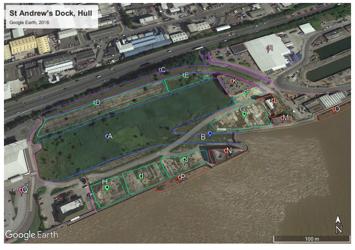
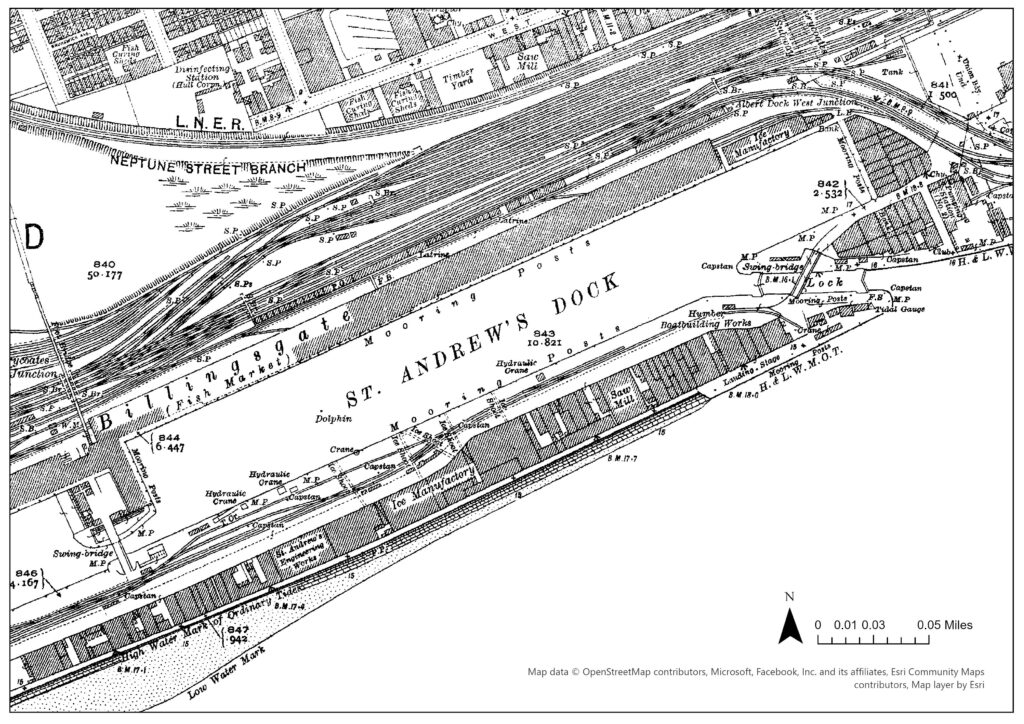
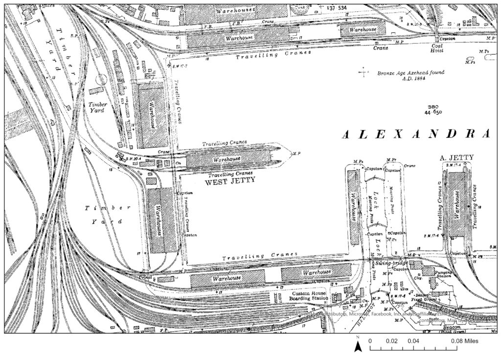
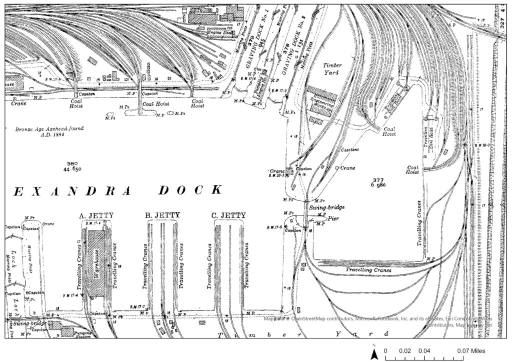
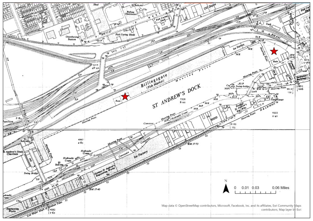
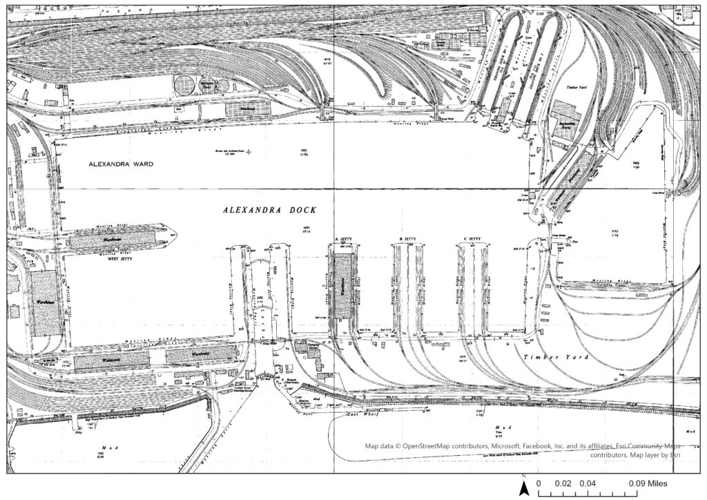
Within Hull’s heritage, that being the history actively remembered and considered culturally valuable by the community, the fishing industry is typically championed.[1] One visual iteration of this is the number of memorials and monuments across the city dedicated to trawlermen and the wider fishing community. Heavy casualties amongst fishermen naturally left remnant feelings of loss and sacrifice, which increased its significance in terms of heritage. A more varied maritime history, however, brought prosperity and status to the port of Hull but is seldom regarded with the same importance. For comparison, St Andrew’s Dock and Alexandra Dock were both built in the 1880s, with the former dedicated to landing fish and the latter holding more varied trade, including timber and coal.[2] Alexandra Dock (Figures: 2&3) had significantly more investment in infrastructure than St Andrew’s (Figure: 1), as can be seen through the disparity in dockside technology such as number of cranes and railway lines, suggesting it was more prosperous.

Figure 1: Megan Seeney, “St Andrew’s Dock, 1920s”, JPEG map, Scale 1:2500, 1:2500 County Series 2nd Revision, 1 January 1928, ArcGIS, using Digimap County Series 1:2500 (1853-1951) Collection, https://digimap.edina.ac.uk/, created 15 January 2024.
Figure 2: Megan Seeney, “Alexandra Dock (Westside), 1920s”, JPEG map, Scale 1:2500, 1:2500 County Series 2nd Revision, 1 January 1928, ArcGIS, using Digimap County Series 1:2500 (1853-1951) Collection, https://digimap.edina.ac.uk/, created 15 January 2024.
Figure 3: Megan Seeney, “Alexandra Dock (Eastside), 1920s”, JPEG map, Scale 1:2500, 1:2500 County Series 2nd Revision, 1 January 1928, ArcGIS, using Digimap County Series 1:2500 (1853-1951) Collection, https://digimap.edina.ac.uk/, created 15 January 2024.

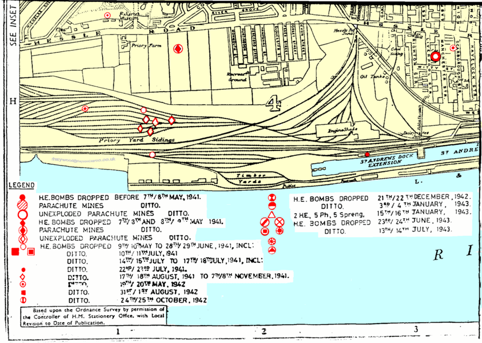
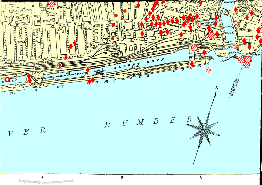
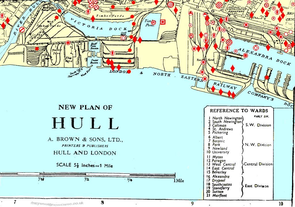
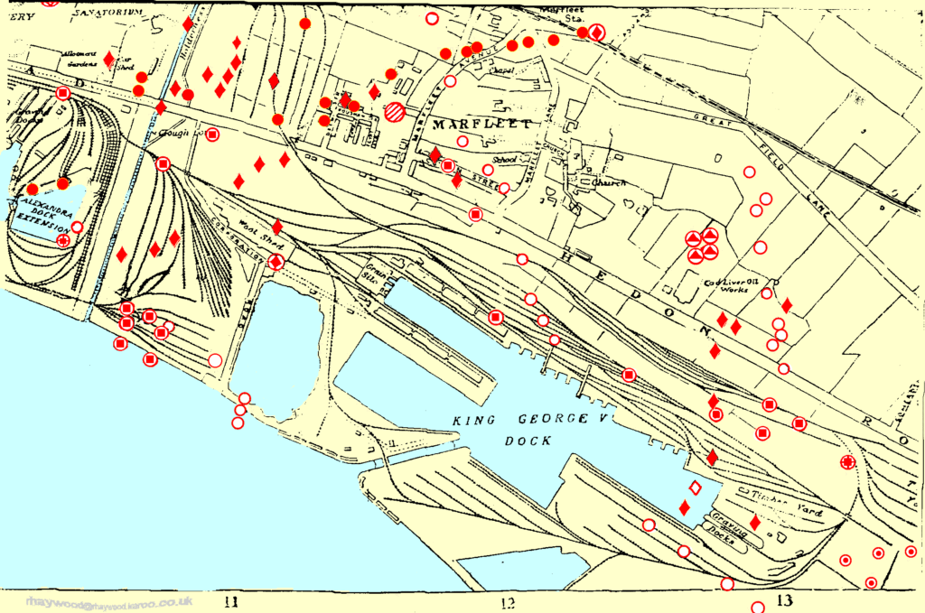
Further to this, considering the docks were strategic targets for Axis bombing campaigns during WWII, Alexandra Dock was much more heavily affected than St Andrew’s. Figures 4-7 show the locations of all High-explosive and Parachute Mines dropped on the city.[3] Alexandra had upward of twenty-five direct hits, with many more in proximity (Figures: 6&7), compared to just four on St Andrew’s and its extension (Figures: 4&5). As such the trade activity of Alexandra Dock was inferably of larger importance than that of St Andrew’s, and thus a more significant target for bombers, as its coal and timber, for example, were vital to continuing domestic industry and the wider Allied war effort. Moreover, Figure 9 (when compared with Figures: 2&3) shows all but the warehousing on the northwest corner of Alexandra Dock was rebuilt in the decade after the war, compared to St Andrew’s where the three areas hit by bombs on the main dock were still labelled as ‘ruin’ (see stars on Figure 8) indicating a lack of investment in rebuilding efforts.

Figure 4: Rob Haywood, The Hull Blitz, 2021, Tile 13, 5.5 inches:1 mile scale, http://www.rhaywood.karoo.net/pics/maps/13.gif.
Figure 5: Rob Haywood, The Hull Blitz, 2021, Tile 14, 5.5 inches:1 mile scale, http://www.rhaywood.karoo.net/pics/maps/14.gif.
Figure 6: Rob Haywood, The Hull Blitz, 2021, Tile 15, 5.5 inches:1 mile scale, http://www.rhaywood.karoo.net/pics/maps/15.gif.
Figure 7: Rob Haywood, The Hull Blitz, 2021, Tile 16, 5.5 inches:1 mile scale, http://www.rhaywood.karoo.net/pics/maps/16.gif.
Figure 8: Megan Seeney, “St Andrew’s Dock, 1950s – labelled”, JPEG map, Scale 1:2500, 1st Edition (1943-1995) National Grid 1:2500, 1 January 1950 and 1 January 1951, ArcGIS, using Digimap National Grid 1:2500 (1943-1995) Collection, https://digimap.edina.ac.uk/, created 15 January 2024.
Figure 9: Megan Seeney, “Alexandra Dock, 1950s”, JPEG map, Scale 1:3500, 1st Edition (1943-1995) National Grid 1:2500, 1 January 1951 and 1 January 1953, ArcGIS, using Digimap National Grid 1:2500 (1943-1995) Collection, https://digimap.edina.ac.uk/, created 15 January 2024.

[1] Rodney Harrison, “What is Heritage?” in Understanding the Politics of Heritage, ed. Rodney Harrison (Manchester: Manchester University Press, 2010), 9.

[2] David Gerrard, A Century of Hull: Events, People and Places over the 20th Century (Stroud: The History Press, 2009), 13.

[3] Rob Haywood, “The Hull Blitz: A Bombing Map,” RHaywood, accessed on 3 January 2024, http://www.rhaywood.karoo.net/bombmap.htm.
Originally plotted c.1945 but digitised by Haywood, a local historian. Incendiary bombs were not included. Points referenced in Map Analysis were cross-referenced with Nick Cooper, City on Fire: Kingston upon Hull 1939-45 (Stroud: Amberley Publishing, 2017), 81-88.

St Andrew’s Dock: History within the Landscape

Mini Project 1: Image Interpretation using Google Earth


The use of aerial photography for archaeological image interpretation is not a new technique, with the 1906 Stonehenge exploration via army balloon thought to be the earliest example in England.[1] However a significant improvement in the technologies available has expanded the potential benefits of such methods.[2] The approach can now assist archaeologists in effectively monitoring Scheduled Monuments, allowing subtle changes overtime to be detected.[3] Aerial and satellite image interpretation also allows researchers to identify sites of potential interest quicker, and over a wider area, compared to ground visits alone. This is particularly useful when the landscape is at risk of disturbance and protected status must be allocated quickly.[4]

Taking the example of St Andrew’s Dock, Hull – which closed in 1975 and has seen no redevelopment since – satellite imagery reveals the clearly defined shape of the old dock (Figure 1: A), lock (Figure 1: B), and bullnose (Figure 1: N), as well as a disused road which serviced the quay (Figure 1: C). Further, the position of the derelict buildings remaining (Figure 1: K – N) can be understood better relative to the wider landscape they were originally constructed amongst, especially as the outlines of now demolished buildings can still be observed (Figure 1: D – J).

Figure 1: A map from Google Earth (satellite, 2018) showing St Andrew’s Dock – edited, 2023, screenshot, https://earth.google.com.

Legend (for Figure 1):

A – St Andrew’s Dock
B – Two sets of lock gates (though only one set remains intact) towards St Andrew’s Dock
C – North Road including a subway tunnel north, originally towards Hessle Road connected via Subway Street.
D – Billingsgate Fish Market
E – Ice Factory
F – J. Marr & Son Ltd., seafoods
G – Various smaller building/units, including a bank and a working man’s club when the dock closed in the 1970s.

H – Various smaller dock buildings/units
I – Various smaller dock buildings/units
J – Humber-St Andrew’s Engineering Works
K – Lord Line, shipping office
L – Hydraulic Pump House
M – Globe Engineering, insurance building
N – Dock building
O – Jetty
P – Jetty
Q – St Andrew’s Quay Retail Park
R – Cranswick plc.

The imagery was analysed for any visible defined shapes, and areas of differing colour or texture, which can indicate the remnants of a manmade structure (as seen in Figure 1: C – J). After the sites of interest were identified, historic GIS Ordnance Survey maps (such as those utilised in Map Analysis) were used alongside twentieth century photography, including that in Fish Dock, to assign function to the structures.[5] In the case of St Andrew’s, where the recent history is fairly well documented, the use of image interpretation can still provide unique insights. For instance, the dimensions of now demolished buildings can be taken and historical photography may be better attributed to its exact position, allowing a fuller understanding of the history of the dockland to be had.


[1] Robert H. Bewley, “Aerial Survey for Archaeology,” Photogrammetric Record 18 (2003): 274.

[2] Bob Bewley and Kieron Niven, “Guides of Good Practice: Aerial Photography and Interpretative Mapping,” Archaeology Data Service, accessed 3 January 2024, https://archaeologydataservice.ac.uk/help-guidance/guides-to-good-practice/data-collection-and-fieldwork/aerial-survey/aerial-photography-remote-sensing/aerial-photography-and-interpretative-mapping/.

[3] Bewley, Aerial Survey, 277.

[4] Louise Rayne, et al., “From Above and on the Ground: Geospatial Methods for Recording Endangered Archaeology in the Middle East and North Africa,” Geosciences 7 (2017): 111.

[5] Michael Thompson, Fish Dock: The Story of St. Andrew’s Dock Hull (Beverley: Hutton Press, 1989).