Dr Louise Rayne
Newcastle University
Dr Nichole Sheldrick
Leicester University
Dr Maria Carmela Gatto
Polish Academy of Sciences
maria.carmela.gatto67@gmail.com
Script
https://code.earthengine.google.com/19471bd071c6448380e3cdf26b1ccdd9
Introduction
There’s been a lot of excitement on remote sensing twitter lately since the Dynamic World land cover product was released (Brown et al 2022). Straight away, it occurred to us that it could be used with our existing Google Earth Engine workflow for monitoring damage to archaeological sites at risk of destruction from land use change such as urban and agricultural expansion. The key thing about this product is that it is dynamic, while other ready-made land cover products have been constructed for set time periods. Dynamic World is derived from supervised classification using a Fully Convoluted Neural Network model of open-source Sentinel-2 satellite images. The output is divided into 9 classes describing the materials present on the Earth’s surface. It can be incorporated into Google Earth Engine scripts and manipulated according to the user’s workflow. Google Earth Engine is a programming interface that allows free access to a catalogue of remote sensing datasets as well as cloud-based high performance processing power.
Workflow
Using Google Earth Engine, we incorporated the Dynamic World layer into Rayne’s existing change detection code (see detailed methods in Rayne et al 2020). This was originally set up as part of the work of the Endangered Archaeology of the Middle East and North Africa Project (EAMENA), which since 2015 has been populating a vast database of archaeological sites. The code comprises a simple per-pixel change detection which compares two Sentinel-2 median composites, constructed by first filtering the image collections by date and cloud cover. The information from the change layer is then appended to user-defined buffers around each site.
One of the case studies we discussed in the 2020 paper was the region around Aswan in Egypt. The script found that there had been change within 100 m of 73 of 279 archaeological sites, with an overall accuracy of 85% (user’s 61%, producer’s 78%). The main limitation of EAMENA’s change detection approach is that it does not identify change between different types of landcover. The Dynamic World dataset offers a way to do this, so we’ve tested it on the same case study in Egypt.
Two composite date ranges were used for this analysis, March-May 2020 and 2022. For the per-pixel Sentinel-2 change detection, a threshold value of 0.2 was applied to the change layer. Other than the dates, the main difference between this script and the one published in 2020 is that the harmonized Sentinel-2 dataset was used (“COPERNICUS/S2_HARMONIZED”) and a mode, rather than a mean, reducer was used on the output sites. Dynamic World composites of matching dates were also created and compared by creating a change layer, from which data was appended to the site buffers in the same way. The information of which landcover classes were involved was retained.
Results
The Aswan area has been surveyed by the AKAP/Borderscape project since 2005. They have recorded hundreds of sites including settlements, scatters of stone tools, temples, cemeteries, and rock art. Unfortunately, the sites are now threatened by modern development activities including urban expansion.
Table 1: Error matrix of Sentinel-2 based change detection. Producer’s accuracy was 59%, user’s 100%, and overall it was 79%.
| Change | No change | Total | |
| Change | 41 | 0 | 41 |
| No change | 29 | 70 | 94 |
| Total | 70 | 70 | 140 |
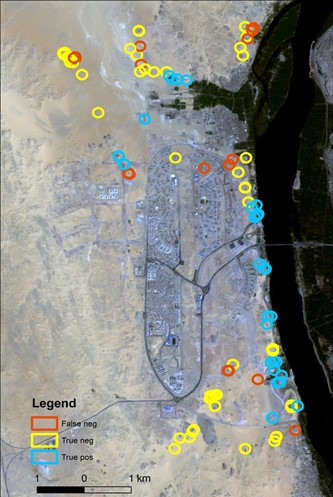
Figure 1: Results of change detection using Sentinel-2 based change detection
To assess the accuracy of the Sentinel-2 composite based change detection, a sample of 140 sites were checked against the matching Sentinel-2 composites (Table 1 and Figure 1). While there were no false positives, as evidenced by the user’s accuracy, the producer’s accuracy is quite low at 59%. Some instances of change were missed, especially issues like small areas of bulldozing or soil colour change, or roofs being added to buildings that were still unfinished in the earlier composite. It is possible that the threshold value of 0.2 is slightly too low. Lowering it to 0.1 would miss less instances of change but would increase the number of false positives.
Table 2: Error matrix for the Dynamic World based changed detection. Producer’s accuracy was 55%, user’s 91%, and the overall accuracy was 73%.
| Change | No change | Total | |
| Change | 39 | 6 | 45 |
| No change | 32 | 63 | 95 |
| Total | 71 | 69 | 140 |
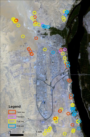
Figure 2: Results of change detection using Dynamic World based change detection
The results of the Dynamic World based change detection (Table 2 and Figure 2) were checked against the Sentinel-2 composites for the same sample of sites. Whether or not change between classes had occurred was recorded; the accuracy of the classes themselves was not checked in this case. The producer’s accuracy was even lower for this dataset, possibly because areas of urban construction were rarely distinguished from the bare soil class.
Conclusion
All too often, archaeological sites are destroyed rapidly by modern development, before the risks can be identified and the sites protected. The use of both the Dynamic World-based and Sentinel-2 datasets for change detection offers a fast way of making this kind of assessment, although our workflow needs further refinement and validation. In particular areas of soil disturbance prior to building work need to be more accurately classified and not lost in a bare soil class. In combination, however, the two datasets can alert archaeologists to sites which are at risk of being destroyed by particular activities.
References
Brown, C.F., Brumby, S.P., Guzder-Williams, B. et al. 2020. Dynamic World, Near real-time global 10 m land use land cover mapping. Sci Data 9(251) https://doi.org/10.1038/s41597-022-01307-4
Rayne, L., Gatto, M.C., Abdulaati, L., Al-Haddad, M., Sterry, M., Sheldrick, N. and Mattingly, D., 2020. Detecting change at archaeological sites in North Africa using open-source satellite imagery. Remote Sensing, 12(22), p.3694. https://doi.org/10.3390/rs12223694
Endangered Archaeology in the Middle East and North Africa | EAMENA Project