The Last Day

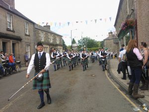
As a reward for all their hard work, and to make up for the really wet day of fieldwork on Thursday, we went off to Langholm on Friday to see the Common Riding (http://www.langholm-online.co.uk/), a form of beating the bounds tied in with lots of horse riding and parading of symbols through the town, followed by games and races (both horse and on foot). We watched the impressive parades with the carrying of four symbols – a bannock and fish pinned to a board, a spade with a spray of heather, a floral crown and the most enormous bunch of thistles you will ever see. Most of the town seem to have joined in, all dressed up with the town colours of red and green, carrying bunches of heather on poles. The town brass band and the pipe band were part of it, followed by all the horses and riders which numbered in the 100s. A spectacular site! We also saw the second proclamation of the rights of the town by the cornet, or Master of ceremonies. A good end to the fieldwork part of the project.

WP_000140 WP_000142

Last day of fieldwork…

Today we concentrated on the northern part of our survey area, on Crew Moor north of Bewcastle. A very wet day, so half the team stayed inside and caught up with essential paperwork and writing up field and survey data. Hamish, Bella and Tillie, led by Richard, went out with Mike Jackson, the local historian who has done a lot of research on Bewcastle parish. They walked over Crew Moor with him, using the GPS to locate sites that had previously been identified by him, and recording a few new ones.

They came back tired and wet, but having achieved a lot of good work in a single day. The sites from Crew Moor can now be added to all those we have found in the southern part of the survey area, over 60 so far. We certainly feel we have added something new to the story of the historic landscape of this area. A great effort by the team of Newcastle University archaeology students. We have met and talked to several of the local farmers whose land we were surveying. Almost all showed great interest in what we were doing, and we will certainly let them know what our final results are.

Tomorrow, we are all off to the Langholm Common Riding, just over the border into Scotland, to appreciate other cultural aspects of the borders. Will Elliott be brave enough to enter the Cumberland and Westmorland wrestling? Watch this space……

I can’t believe it’s not Branston!

What a glorious start to the day! Crumpets and coffee with a side of landscape survey sheets for Elliott and Tilly. They were recording and describing what they saw yesterday whilst on a windy walk across the Gillalees Farm land. These sheets consolidate what we see on site and help us to understand how the landscapes connect. They are also helpful for presenting information to the general public.

Kimberley, Chris and Hamish ventured out with the TST to Rinnion Hills in pursuit of  a possible tower and remains of a structure. After many hours, earthworks south east of the site were found that formed the shape of a structure along with fragments of architectural stone works (probable rubble) just north of the site. The Farmer and his family paid us a visit to discuss the archaeology.  It’s good to engage the locals on the history of their land. We all came back to some beautiful sandwiches that (for once) was not branston pickle, it was yet another great find.

Richard and Elliott finished the day with a stroll up to the beacon to record a possible dry stone waller’s hut, and recorded their findings on the GPS.


DSC_0005 (2)DSC_0014 (2)

Rocky Road to Rock Art….

Tillie joined us today, and we gave her a gentle start by sending her onto the moors with Kimberley to survey a shieling. We were also joined for the day by local historian, Mike Jackson, who has been very generous in sharing his research with us on the Bewcastle area. Today, however, we took him over the work we have done so far to the south of Bewcastle, and we spent the time walking long boundaries, finding shielings and farmsteads and, most particularly, new rock art sites. Tillie discovered one site which we had not seen before, not bad for her first day.


DSC_0016

DSC_0019

Top photo shows a large cup and ring marked rock and the bottom photo is the rock found by Tillie with a number of cup marks on the top and side.

DSC_0024

A tired but happy team on the way home after a long but productive day. Well done everyone!


Treasure maps!

A more relaxing couple of days this weekend, with a visit to Carlisle Castle, where Bella chatted up King Henry VIII! Today (Sunday) we compared our results with maps from 1603, and were thrilled to find that one earthwork site we found on Tower Brae, and had thought might be a the foundations to a tower, actually matched up to a tower on the map of Askerton.  The written survey that goes with the map describes many farmsteads and tenements that no longer survive, but that seems to match with many of the sites we have found. It’s clear that at the end of the medieval period, there were many more people living between Hadrian’s Wall and the Scottish border than there were in the 18th century.

HNP C713-002 Askerton

In this excerpt from a map of Askerton (1603) a tower can be seen, marked in red near the bottom and is labelled as a tenement of the Armstrongs. We think we have found the foundations of this tower on the moor called Tower Brae.

Bella’s Boudoir Blog

0045_shieling1

Shieling at Gillalees

DSC_0057

Earthwork enclosures at The Beacon with great views across north Cumbria and into southern Scotland

We began the day as usual, painfully early. I was awoken from sweet slumber by a bang on the door which could have turned Elton John straight. The day had begun, peril lay ahead. Once we congregated as a group we split the group into two teams. Caron, Kimberley, Elliot and Chris were stationed at Gillalees Farm whilst myself, Hamish and Richard braved the journey to Tower Brae. The weather was mild with bouts of Apollos ray’s scattered amongst the pastures. My team had trudged through the various excrement and rush, which saturated our boots along the way, finally ascending up the hill toward Tower Brae. On the ascend we came across various archaeological wonders including an abandoned lime kiln and various shielings. Hamish and I were trusted (miraculously) with the highly technological GPS system powered by Magellan, to whom I will write a strongly worded message about their abysmal software. Using this fruitful software we were able to record and measure the sites which enabled us to locate them on a map later. On the other side of the moors, Caron and her team were working on topographical  surveying. They focused heavily on a shieling they discovered previously and also on an earthwork mound. Caron and her team also explored multiple rock art sites, amongst which they found several new ones! All in all the day was an archaeological marvel – one didn’t have to throw the trowel in! (apologies). The following day we spent the majority of our time within the comfort of the research lair, which by night is my personal boudoir. Slaves to the modern fruits of technological software we logged and tracked all our previous pursuits on the computers provided.

(Caron says, ‘the archaeology students have all put in a lot of work over the last couple of days, learning new skills. We have also had a lot of interest from the farmer and his family, and it has been great to show them some of the sites we have discovered’).

Weather as usual!

DSC_0075,

A sign of what was to come. Fantastic thunderstorms today, so we took the opportunity to catch up on our paperwork and for the archaeology students to learn more about using GIS and desk-based research in general. Halfway through the first week, and we already have more than 10 sites not previously recorded. Back out in the field tomorrow to survey in yet more new sites spotted on aerial photographs.

Kimberley Joins the Team

Today, Kimberley joined our small team, having graduated the previous day (well done Kimberley!). Caron, Kimberley and Bella went out surveying with the GPS, recording a couple of settlement sites, some ridge and furrow and a long boundary. With storms forecast for tomorrow, we will take stock, load our results into the GIS and plan the rest of our surveying campaign.

While we were working, the farmer and his family came and chatted to us. They have lots of knowledge about the historic features on the farm, but were interested to find out about the earthworks and stone foundations of an earlier farm, right across the road from the present day farmstead. We have begun recording it with the GPS and will come back to do a more detailed topographic survey. At this early stage we think we may have the foundations of a tower.

Later that day, we spoke to the farmer again when he visited us on a site that he had thought was a sheep fold, but which we think may be a previously unrecorded shieling with an attached fold. Photos to follow in a couple of days

Hamish’s First Day Surveying….

Marched around the glorious hills of Cumbria in 30 degree heat at a time of day unseen by students, yes, the project had started. Richard, Elliot and I were the first group to head out that morning to record and check up on various sites around the Gillalees area. We got off to a fantastic start with our first site, finding prehistoric rock art in the form of circular, indented patterns in the rock face, from which we deduced must have been part of some wider boundary markings given the parallel running rock sites.

From the prehistoric rock art we moved onto a site at the peak of the Gillalees area – ‘The Beacon’. For this we already had background knowledge: a beacon that would have been lit to warn English defenders against a Scottish threat. This information helped in interpreting what the surrounding banks and ditches may have been used for (site for storage of wood, site where beacon would have been lit, etc). As was done with the prehistoric rock art, photos were taken with relevant scaling and measurements taken. The rest of the day was spent scanning the surrounding area, particularly Tower Brae, recording a few sites that will be returned to with GPS equipment due to their scale.

DSC_0002 DSC_0026

Rock art at Gillalees and one of the newly discovered settlement sites