A more relaxing couple of days this weekend, with a visit to Carlisle Castle, where Bella chatted up King Henry VIII! Today (Sunday) we compared our results with maps from 1603, and were thrilled to find that one earthwork site we found on Tower Brae, and had thought might be a the foundations to a tower, actually matched up to a tower on the map of Askerton. The written survey that goes with the map describes many farmsteads and tenements that no longer survive, but that seems to match with many of the sites we have found. It’s clear that at the end of the medieval period, there were many more people living between Hadrian’s Wall and the Scottish border than there were in the 18th century.
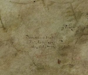
In this excerpt from a map of Askerton (1603) a tower can be seen, marked in red near the bottom and is labelled as a tenement of the Armstrongs. We think we have found the foundations of this tower on the moor called Tower Brae.