Marched around the glorious hills of Cumbria in 30 degree heat at a time of day unseen by students, yes, the project had started. Richard, Elliot and I were the first group to head out that morning to record and check up on various sites around the Gillalees area. We got off to a fantastic start with our first site, finding prehistoric rock art in the form of circular, indented patterns in the rock face, from which we deduced must have been part of some wider boundary markings given the parallel running rock sites.
From the prehistoric rock art we moved onto a site at the peak of the Gillalees area – ‘The Beacon’. For this we already had background knowledge: a beacon that would have been lit to warn English defenders against a Scottish threat. This information helped in interpreting what the surrounding banks and ditches may have been used for (site for storage of wood, site where beacon would have been lit, etc). As was done with the prehistoric rock art, photos were taken with relevant scaling and measurements taken. The rest of the day was spent scanning the surrounding area, particularly Tower Brae, recording a few sites that will be returned to with GPS equipment due to their scale.
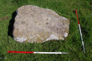
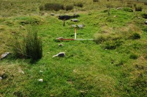
Rock art at Gillalees and one of the newly discovered settlement sites