Last month, Peter Clarke and Stuart Edwards spent a week at the National Mapping and Resource Information Agency (NAMRIA) in the Philippines, leading a training course on crustal deformation modelling and dynamic datum definition, and consulting with stakeholders in the expanding Philippine Active Geodetic Network (PageNET) of continuous GNSS receivers. This is part of a project led by Ordnance Survey International to assist NAMRIA in developing geodetic user services such as network RTK GNSS. You can read more about the visit on NAMRIA’s news page.
Category Archives: Uncategorized
Postdoc vacancy in GNSS geodesy
We have a vacancy for a postdoctoral researcher in GNSS geodesy to work on a range of deformation monitoring projects including glacial monitoring, for three years in the first instance. For more details and to apply please see the University vacancies website, or contact Stuart Edwards with informal enquiries only.
“Satellite data reveal the depths of the megacity’s thirst”
A recent paper by Zhenhong Li and collaborators using satellite Radar Interferometry to highlight the affect of land subsidence induced by groundwater extraction in Beijing has been featured by Circle of Blue.
Recent research summary for EUREF
With the help of colleagues, I’ve just finished writing a brief summary of our geodetic research in the last year, as a contribution to Ordnance Survey’s national report for Great Britain to the EUREF 2016 meeting. The EUREF 2016 Newcastle report shows that it’s been a very productive year for the group, with publications across a wide range of topics. Hopefully more to come this year!
Kinematic GNSS estimation of tropospheric water vapour
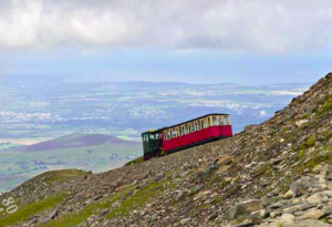
At long last, Sam Webb’s paper on fully-kinematic GNSS estimation of tropospheric water vapour throughout a trajectory ranging from ~100-1100 m above mean sea level, is out (gold Open Access). Thanks again to Snowdon Mountain Railway for supporting the fieldwork, the NERC British Isles continuous GNSS Archive Facility for ancillary data provision, and of course our collaborators at the Met Office.
Samuel R. Webb, Nigel T. Penna, Peter J. Clarke, Stuart Webster, Ian Martin, and Gemma V. Bennitt (2016). Kinematic GNSS Estimation of Zenith Wet Delay over a Range of Altitudes. J. Atmos. Oceanic Technol., 33(1), 3–15.
doi:10.1175/JTECH-D-14-00111.1
Two papers on ocean tide loading
Just out in the Journal of Geophysical Research – Solid Earth (accepted articles online), are two articles on ocean tide loading (OTL) research that Nigel Penna, Peter Clarke and collaborators Machiel Bos (University of Beira Interior) and Trevor Baker (formerly at the National Oceanography Centre, Liverpool) have been working on for the last few years (originally funded by NERC).
Paper 1 uses known, synthetic OTL signals inserted in real GPS data to validate the use of kinematic GPS for the recovery of ocean tide loading displacements to within ~0.2 mm amplitude error, using at least 3-4 years’ data, and establishes the importance of correct, simultaneous, estimation of tropospheric delay parameters. The measurements are shown to be robust with respect to typical levels and patterns of data loss, and levels of reference frame noise, and a heuristic relationship between site background noise and OTL measurement error is proposed.
Paper 2 presents OTL measurements at the M2 tidal period across western Europe, and shows how discrepancies of up to 2-3 mm with respect to modelled values cannot be explained by credible errors in the numerical ocean tide models or elastic solid Earth response models. The discrepancies can be explained only by changes in the solid Earth response that correspond to anelastic behaviour in the asthenosphere at tidal periods.This anelastic behaviour corresponds to 8-10% reduction in the shear modulus in the asthenosphere, consistent with an absorption band of constant Q~70 stretching from seismic frequencies (1 Hz) through to the semi-diurnal tidal band (2 cycles per day).
SLR geocentre research published
Ciprian Spatar, final-year PhD student working with Phil Moore and Peter Clarke, has just had his paper on “Collinearity assessment of geocentre coordinates derived from multi-satellite SLR data” published online in the Journal of Geodesy (open-access author preprint also available).
CPD courses on GNSS
This week we welcome delegates from OSNI, WS Atkins, Colas Rail, Tata Steel, Leica Geosystems, Murphy Surveys, Plowman Craven Ltd, Fugro, and Forestry Commission Scotland for one or both of our linked CPD courses ‘GNSS and Network RTK‘ and ‘High precision GNSS using post-processing‘, building on our previous GNSS benchmarking work for The Survey Association.

