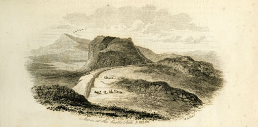
This image of Hadrian’s Wall is by W. Collard and is from a version of the 1884 book, The hand-book to the Roman wall: a guide to tourists traversing the barrier of the lower isthmus by John Collingwood Bruce. The book belonged to John Oxberry who added illustrations and notes to it.
On 13th March 2010, an event entitled ‘Illuminating Hadrian’s Wall’ lit-up the Roman wall from one end to the other to form a line of light from coast to coast in celebration of the landscape and heritage of Northumberland and showing the scale of Hadrian’s Wall.
Hadrian’s Wall was built on the orders of the Roman Emperor Hadrian around AD130 and was operated, manned and maintained for almost 300 years. It is 73-miles long and runs from Wallsend, Tyne and Wear, on the east coast to Bowness-on-Solway, Cumbria, in the west. It is still unclear what purpose lay behind its construction, but it was probably built for defence and in order to define the northern frontier of the Roman Empire in Britain. Much of the length of the wall can be followed on foot and it is the most popular tourist attraction in Northumberland. It was designated as a UNESCO World Heritage Site in 1987.
Hadrian’s Wall has been a popular attraction for tourists since the Eighteenth Century. Interest in the site initially came about as a result of a new awareness of the importance of the physical remains of the past and interest in the Classical world. This was partly inspired by the ‘Grand Tour of Europe’, which was undertaken by young men from mainly upper-class families from around 1660 onwards. Most tours followed a standard itinerary, which tended to include Italy and which led to an increased interest in the legacy of classical antiquity. Additionally, following the opening of the Military Road in the 1750s, which followed the line of the wall, the uplands of Northumberland became more accessible to visitors.
During the Nineteenth Century, a number of important developments helped to further increase the popularity of the wall with tourists. In 1832, John Clayton, an antiquarian and town clerk in Newcastle upon Tyne, inherited land containing Chesters Roman Fort. Clayton dedicated his life to funding the excavation, protection, and reconstruction of the remains of the wall and, in 1896, a museum at Chesters was constructed to house the collection of Roman objects that he had discovered during his excavations. A number of ‘learned societies’ were also established during this period devoted to the study of antiquities. These societies increased interest in the wall and introduced it to a wider audience. In 1849, the first pilgrimage travelling the full length of the wall was led by John Collingwood Bruce, and in 1863 he published his Handbook of the Roman Wall, which became a popular tourist guide.
The late Nineteenth Century saw the first public acquisition and display of part of the wall by a public authority and 1927 saw the first portion of the wall to be scheduled as an ancient monument. After the Second World War, the beginnings of mass tourism came to the site as increased car ownership and more leisure time brought further visitors and it became more important than ever to protect the wall. Today, many of the sites along the wall have been acquired for the public and are managed and conserved by county councils, trusts and charities.