Viva success – Polpreecha Chidburee

On Tuesday Polpreecha Chidburee successfully passed his viva for his thesis entitled “Landslide monitoring using mobile device and cloud-based photogrammetry” (subject to minor revisions). Professor Phil Moore (internal) and Professor Jim Chandler (external, Loughborough University) were the two examiners. Polpreecha is now returning to Thailand to take up a lectureship position at Naresuan University. Well done and good luck in the future!

Thesis abstract:

Landslides are one of the most commonly occurring natural disasters that can cause a serious threat to human life and society, in addition to significant economic loss. Investigation and monitoring of landslides are important tasks in geotechnical engineering in order to mitigate the hazards created by such phenomena. However, current geomatics approaches used for precise landslide monitoring are largely inappropriate for initial assessment by an engineer over small areas due to the labour-intensive and costly methods often adopted. Therefore, the development of a cost-effective landslide monitoring system for real-time on-site investigation is essential to aid initial geotechnical interpretation and assessment.

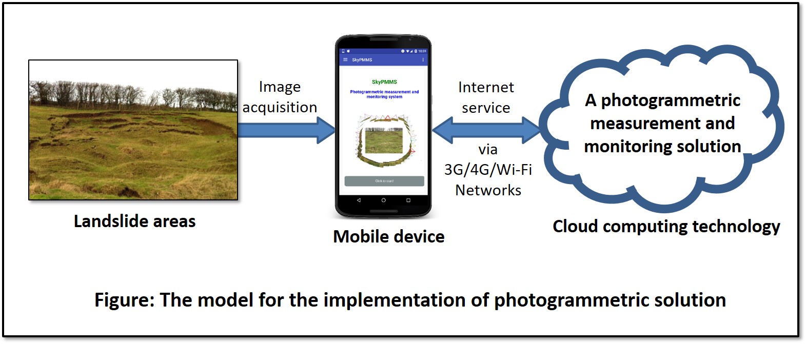
In this research, close-range photogrammetric techniques using imagery from a mobile device camera (e.g. a modern smartphone) were investigated as a low-cost, non-contact monitoring approach to on-site landslide investigation. The developed system was implemented on a mobile platform with cloud computing technology to enable the potential for real-time processing. The system comprised the front-end service of a mobile application controlled by the operator and a back-end service employed for photogrammetric measurement and landslide monitoring analysis. In terms of the back-end service, Structure-from-Motion (SfM) photogrammetry was implemented to provide fully-automated processing to offer user-friendliness to non-experts. This was integrated with developed functions that were used to enhance the processing performance and deliver appropriate photogrammetric results for assessing landslide deformations. In order to implement this system with a real-time response, the cloud-based system required data transfer using Internet services via a modern 4G/5G network. Furthermore, the relationship between the number of images and image size was investigated to optimise data processing.

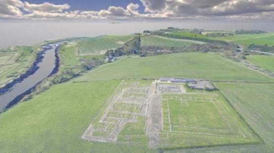
The potential of the developed system for monitoring landslides was investigated at two different real-world UK sites, comprising a natural earth-flow landslide and coastal cliff erosion. These investigations demonstrated that the cloud-based photogrammetric measurement system was capable of providing three-dimensional results to sub-decimetre-level accuracy. The results of the initial assessments for on-site investigation could be effectively presented on the mobile device through visualisation and/or statistical quantification of the landslide changes at a local-scale.

The Future of Cultural Heritage: Free Seminar

Corbridge Roman Town

As part of Newcastle University’s ‘Inspired by’ Great Exhibition of the North programme, Dr Maria-Valasia Peppa from the School of Engineering and NEOlab, will be discussing some of her work investigating changes in our cultural heritage.

Cultural heritage has large historical, social, and anthropological values and is an important enabler of sustainable development. Join researchers at Newcastle University in exploring how technologies, such as remote sensing and 3D printing, are used to safeguard the world’s cultural heritage for future generations.

The event is free to attend, however you need to register here.

The event is on the 26th July at 1 Science Square, and will start at 7pm.

Hope to see you there!

5th ESA Advanced Training Course on Land Remote Sensing

City of Arts and Science, Valencia

Last September (2014), I was fortunate to attend the 5th Advanced Training Course on Land Remote Sensing, organised by the European Space Agency (ESA) as part of the Scientific Exploitation of Operational Missions (SEOM) programme. This 5-day course took place at University of Valencia, in the sunny eastern Spain, gathering together early career researchers from various countries in an attempt to train the next generation of Earth Observation scientists. This extremely intensive training, delivered by top researchers in the field, covered a wide area of topics and left its participants craving for even more knowledge.

The course was divided into two main groups: SAR and Optical/Thermal, with the second’s programme reported below. The first two days mostly focused on expanding the participants overall knowledge on optical and thermal remote sensing, with advanced sessions provided by J. Moreno and J. Sobrino (Univ. of Valencia). These sessions included, among others, a particularly interesting talk on satellite signal modelling (covering the limitations of currently used leaf and canopy models), as well as a presentation on methods of information extraction and validation. It was followed by an overview of thermal imagery pre-processing steps and methods of land temperature retrieval.

Following this introductory take on remote sensing data processing and signal modelling, the time had come for more specialised sessions; M. Caetano (Foundation of Science and Technology, Portugal) gave a presentation about land cover and land use change monitoring. The applied sessions continued on throughout the third day, with E. Chuvieco (Univ. of Alcalá, Spain) introducing us to fire detection and assessment of its effects, and F. Baret (INRA-CSE, France) speaking about the use of remote sensing techniques for agriculture applications.

On the fourth day, importance was given to multitemporal analysis. L. Bruzzone (Univ. of Trento, Italy) gave an excellent presentation on methods of change detection, which are currently used for various data types (multispectral, VHR multispectral, SAR, VHR SAR and hyperspectral imagery). He also briefly presented an example of multisensor change detection with use of multispectral and SAR data. The day finished with a presentation given by G. Camps-Valls (Univ. of Valencia) on hyperspectral image processing. The last day brought lecture sessions on various remote sensing applications, with E. Tomelleri (EURAC, Italy) giving a talk on carbon cycling and ecosystem modelling, W. Wagner (TU Wien, Austria) on hydrology and climate change monitoring, and T. Wright (Univ. of Leeds, UK) talking about earthquakes and volcanoes observation.

Valencia Cathedral at Plaza de la Virgen (city centre)

Apart from the knowledge-packed programme, the organisers offered the participants a chance to present their work to the rest of the attendees. During the evening poster session, I presented the current progress of my PhD project, entitled “Remote Sensing of Forest Health in UK”, in which I am investigating the potential of integration of different remote sensing data sources for detection of disease stress symptoms. As the course came to an end, the time had come to say goodbye to warm and sunny Valencia and face the reality of coming back to Newcastle.

I would like to thank the RSPSoc for the invaluable financial help, allowing me to attend this course.

Magdalena Smigaj (2nd Year PhD Student)


Note: All of the abovementioned lectures were filmed and are currently available at ESA’s website within the “Space in Videos” section. They can also be accessed through:  http://seom.esa.int/landtraining2014/files/LTC2014_Programme_Materials.pdf