Berwick-upon-Tweed: The fortified town – April 2013

Map of Berwick-upon-Tweed, 1849
Map of Berwick-upon-Tweed from History of Berwick-upon-Tweed: being a concise description of that ancient borough, from its origin down to the present time, by Frederick Sheldon, 1849 (Clarke (Edwin) Local Collection, Clarke 784)

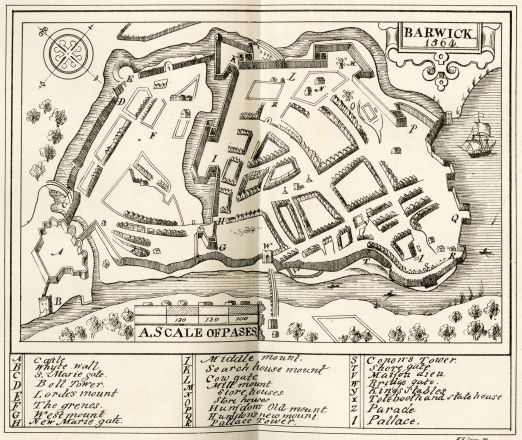
During Elizabeth I’s reign Berwick was heavily fortified to protect it against possible future attacks. This map from 1564 shows the castle, rampart walls and barracks. According to sources over £120,000 was spent on the fortifications, many of which remain today. If true this would make it the most expensive undertaking of the Elizabethan period, amounting to over £25,000,000 of expenditure in today’s money.

In April 1318, Berwick-upon-Tweed was captured by the Scottish in the First War of Scottish Independence. Following the Scottish victory at the Battle of Bannockburn in 1314, they regained all of their strongholds and re-taking Berwick was the culmination of this. The Scots however, could not hold the town and it was soon re-captured by the English. In fact over a period of almost 400 years from the late 10th century the town changed hands more than a dozen times.

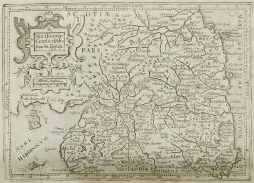
Its strategic position on the border during many years of English/Scottish war, coupled with the fact that it was a wealthy trade town, meant Berwick was constantly under siege between the 11th and 15th centuries. Part of Northumbria and thus England until the late 10th century, the town came under Scottish control (whether by cession or conquest is unclear) and was made a Royal Burgh by David I. William I of Scotland used Berwick as a stage from which to invade northern England in 1173 and following his defeat the town fell back under the English control of Henry II. However, his son Richard I sold it back to William I in order to raise funds for his crusade.

The 13th century saw much battling and bargaining for the increasingly prosperous town. William Wallace’s severed arm was displayed in Berwick following his execution and quartering in 1305. After the Scots triumphed over the English at the Battle of Bannockburn, they blockaded the town between 1315 and 1318 finally invading and capturing it in April 1318. The English took it back in 1333 and held it until 1461 when deposed King Henry VI’s wife Margaret of Anjou gifted it to the Scots for their help against the Yorkists during the Wars of the Roses. Finally in 1482, Richard, Duke of Gloucester (and soon-to-be King Richard III) recaptured the town and Berwick has been English ever since.

Mercator’s atlas – March 2012

Map of Northumberland
Map of Northumberland from Mercator, G. Historia mundi: or, Mercator’s atlas: containing his Cosmographical description of the fabricke and figure of the world: lately rectified in divers places, as also beautified and enlarged with new mappes and tables by the studious industry of Ivdocvs Hondy; Englished by W. S.
(London: Printed by T. Cotes for Michael Sparke and Samuel Cartwright, 1635)
(Post-Incunabula Collection: PI 912 MER Quarto)

Gerardus Mercator was born 500 years ago, on 5th March 1512. He was a Flemish cartographer who made it possible to navigate straight paths across the entire ocean.

Although he came to be known for cartography, Mercator’s main income source was initially in the crafting of mathematical instruments and he would later teach mathematics at the academic college in Duisburg.

While working in Leuven, he struck out as an independent mapmaker, producing maps of Palestine (1537), the world (1538) and Flanders (1540). In 1552 he relocated to Duisburg where he opened a cartography workshop and found employment as the city’s surveyor.

Mercator put his atlas together in the early 1570s when the son of his patron, the crown prince of Cleves, was planning a grand tour of Europe. It was based on his cylindrical projection (a major revolution) and compiled from a collection of wall maps that were available in his workshop, as well as some of his own hand-drawn maps. He copied the maps, then cut and pasted them into the bound format that would come to be known as an atlas.

Page from  Mercator, G. Historia mundi
Page from Mercator, G. Historia mundi: or, Mercator’s atlas: containing his Cosmographical description of the fabricke and figure of the world: lately rectified in divers places, as also beautified and enlarged with new mappes and tables by the studious industry of Ivdocvs Hondy; Englished by W. S.
(London: Printed by T. Cotes for Michael Sparke and Samuel Cartwright, 1635)
(Post-Incunabula Collection, PI 912 MER Quarto)

The Philip Robinson Library copy is an ‘Englished’ version of the edition published by Jodocus Hondius (1563-1612). Mercator’s work had become eclipsed by Ortelius’ Theatrum Orbis Terrarum but Hondius purchased the plates for Mercator’s Atlas in 1604 and, in reprinting it with additional maps, re-established Mercator’s reputation. The Mercator/Hondius series would go on to include a second and a pocket edition. This copy also has an illustrated title page from the second edition, printed in London for Micheall [sic] Sparke in 1637 pasted in at the front.