The theatre of the empire of Great Britaine – September 2011

Map of part of Cumberland
Map of part of Cumberland from Speed, John, 1552?-1629.:
The theatre of the empire of Great Britaine : presenting an exact geography of the kingdomes of England, Scotland, Ireland, and the iles adioyning: with the shires, hundreds, cities and shire-townes, within ye kingdome of England.
London, : And are to be solde by I. Sudbury and G. Humble, 1611.
(Post Incunabula, Folio PI 912.42 SPE)

John Speed was born in Fardon, Cheshire in 1552. He was a tailor by trade, working in his father’s business until he was nearly 50. He then moved to London to work, but his main interest increasingly became the study of history. He joined the Society of Antiquaries. An allowance from Sir Fulke Greville enabled him to continue his research full time. William Camden encouraged him to begin a history of Britain.

Map of part of Bishoprick, Durham
Map of part of Bishoprick, Durham from Speed, John, 1552?-1629.:
The theatre of the empire of Great Britaine : presenting an exact geography of the kingdomes of England, Scotland, Ireland, and the iles adioyning: with the shires, hundreds, cities and shire-townes, within ye kingdome of England.
London, : And are to be solde by I. Sudbury and G. Humble, 1611.
(Post Incunabula, Folio PI 912.42 SPE)

The Historie of Great Britaine was published in 1611 but of greater importance was the atlas that accompanied it – The Theatre of the Empire of Great Britaine, published in the same year, which is the subject of this month’s Treasure.

The atlas contains maps for each of the counties of England and Wales, 5 maps of Ireland and a general map of Scotland.

The first map (Cheshire) had been ready for engraving in 1604 but the death, in that same year, of the person selected to engrave the maps caused a serious delay.

In 1607 Flemish engraver Jodocus Hondius Sr. based in Amsterdam was asked to carry out the engraving which was completed between 1607 and 1611.

Map of part of Cumberland
Map of part of Cumberland from Speed, John, 1552?-1629.:
The theatre of the empire of Great Britaine : presenting an exact geography of the kingdomes of England, Scotland, Ireland, and the iles adioyning: with the shires, hundreds, cities and shire-townes, within ye kingdome of England.
London, : And are to be solde by I. Sudbury and G. Humble, 1611.
(Post Incunabula, Folio PI 912.42 SPE)

Probably the earliest county atlas of England and Wales, most of the county maps contain town plans which in many cases were the first depiction of that town.

Although the county maps were based on earlier works many of the town plans were in fact surveyed by Speed.

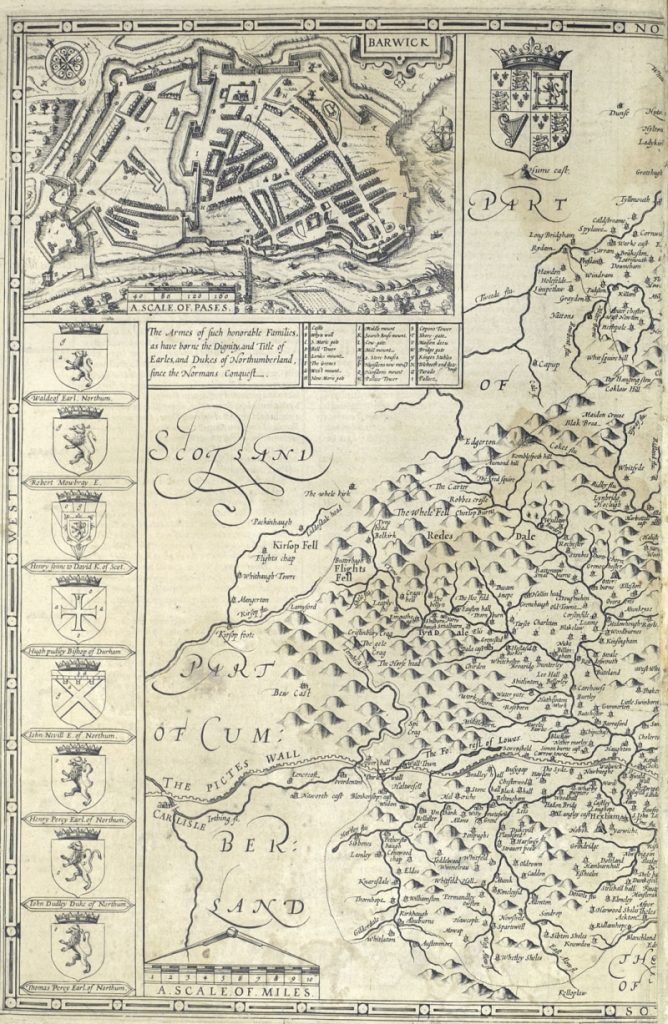
The town plans marked with a Scale of Passes [paces] being those that Speed had surveyed. A pace being equal to 5 feet.

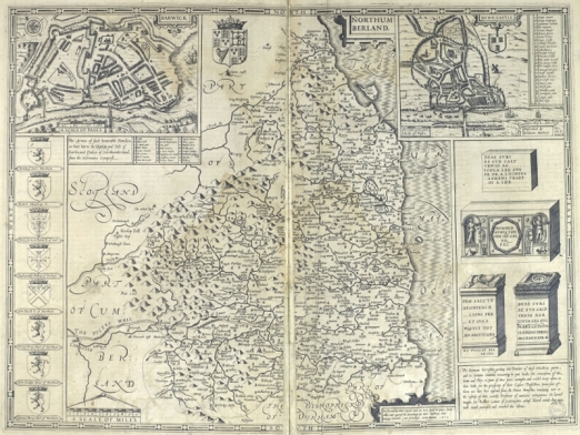
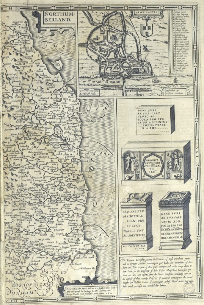
The Library’s copy of The Theatre of the Empire of Great Britaine is incomplete but does include the map for Northumberland. The eastern half of the map includes a plan of Newcastle and various antiquarian objects.

Map of part of North Cumberland showing the Farne Island
Map of part of North Cumberland showing the Farne Island from Speed, John, 1552?-1629.:
The theatre of the empire of Great Britaine : presenting an exact geography of the kingdomes of England, Scotland, Ireland, and the iles adioyning: with the shires, hundreds, cities and shire-townes, within ye kingdome of England.
London, : And are to be solde by I. Sudbury and G. Humble, 1611.
(Post Incunabula, Folio PI 912.42 SPE)

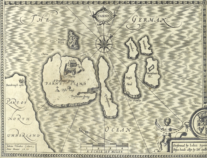
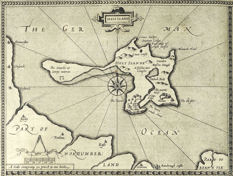
The western portion includes armorials of various local families and a town plan of Barwick [Berwick]. The Theatre of the Empire also includes maps of Farne and Holy Island.

Map of part of Northumberland showing Holy Island
Map of part of Northumberland showing Holy Island from Speed, John, 1552?-1629.:
The theatre of the empire of Great Britaine : presenting an exact geography of the kingdomes of England, Scotland, Ireland, and the iles adioyning: with the shires, hundreds, cities and shire-townes, within ye kingdome of England.
London, : And are to be solde by I. Sudbury and G. Humble, 1611.
(Post Incunabula, Folio PI 912.42 SPE)

Malby’s Celestial Globe-Atlas – September 2010

Section of map detailing Canis Minor, picturing Orion with his two faithful dogs
Section of map detailing Canis Minor, picturing Orion with his two faithful dogs from Malby’s Telescopic Companion or Celestial Globe-Atlas in XXI sheets by John Addison. Exhibiting the whole of the stars contained in the catalogues of Piazzi, Bradley, Hevelius, Mayer, Lacaille and Johnson. The double stars marked from Herschel and Struve. Corrected from Baily’s edition of Flamsteed’s British Catalogue. With additions carefully collated from the observations of the most esteemed British and Foreign astronomers together with the nebulae observed by W. Herschel and Sir J. Herschel (London, 1843)
(Rare Books, RB Folio 523.89 MAL)

Malby’s Telescopic Companion or Celestial Globe-Atlas was published by the map and globe makers Malby & Co. in January, 1843. This handsome volume, with ornate gilt-decorated cloth binding, contains a set of twenty one striking double-page colour plates depicting the stars and constellations in the sky, as recorded by the many renowned astronomers who had identified and listed the stars throughout history.

The constellations into which the sky of the northern hemisphere has traditionally been divided were originally described by the Ancient Greeks, who likened each constellation to a mythological figure or sign of the zodiac, although the Latin forms of their names, rather than the Greek, have traditionally been used. The plates in Malby’s globe-atlas carry colourful artistic representations of these figures. This plate depicts the constellations Canes Venatici, Bootes and Ursa Major. The Canes Venatici (“hunting dogs”), Asterion and Chara, are held on a leash by Bootes the herdsman as they chase the Great Bear (Ursa Major), whose tail can be seen disappearing off to the left of the picture.

Malby’s globe-atlas actually served a dual purpose, as the atlas could either be used in its original form as a book or the sheets could be cut out and joined together according to the instructions provided to create a three-dimensional globe. The firm Malby & Co., established by Thomas Malby in c. 1839, was known for producing maps and globes of varying types and sizes, including table and pocket globes, and associated itself with the geographical publishing of the Society for the Diffusion of Useful Knowledge (SDUK).

The volume is apparently exceedingly rare; the British Library lists only a copy of the 1845 edition in its holdings and no other copies of this particular edition, which appears to be the first, are listed anywhere else.

Adding to its interest, the volume carries the bookplate of Hugh Lee Pattinson, the eminent metallurgical chemist and industrialist from the North-East of England who discovered the process of separating silver from lead, later known as the Pattinson Process. He was also the great grandfather of Gertrude Bell. The Latin motto on his coat of arms reads Ex Vile Pretiosa which means “Valuable things from base things”, an allusion to his momentous discovery.