In this week’s Understanding Code – Python seminar the use of classes were explored. Whilst this felt quite a step up from last week’s topics on variables, for, if and while loops, we were reassured that Phil Jeffes, the seminar presenter, had been studying his undergraduate for two years before classes were introduced.
The examples started with basic implementation of classes; how they are defined and can then have functions called upon them. Towards the end of the seminar, a more complex example was given. Participants were given some code which, when completed, would allow them to move between different rooms of a house depending on the user’s input. To complete the code an if statement was required to determine the user’s input and to catch if the number of inputs exceeded the number of variables in the list.
The Understanding Code series comes to an end next Monday (07th March) where everything taught up to date will be used to link python code to a web browser.
The Understanding Code workshop, given at Campus North, is a series of six sessions learning various aspects of code, held on Monday evenings. The first three sessions covered an introduction to HTML, CSS and styling followed by Javascript and Dynamic Content. The fourth session, given on 22nd February, was the start of three workshops on Python. Whilst there are many different languages available Python is proving to be one of the most popular (http://spectrum.ieee.org/computing/software/the-2015-top-ten-programming-languages).
Python I was well attended with approximately 30 people from all different backgrounds present, including several PhD researchers from within the School of Civil Engineering and Geosciences. The seminar was an introduction to Python involving some basic processing: variables, while, for, if statements and when these might be useful. Classes were briefly introduced at the end of the seminar in preparation for next week’s Python II course.
The course was a really good introduction to Python, keeping it simple and straightforward whilst starting to look at how basic principles can be use in complex cases.
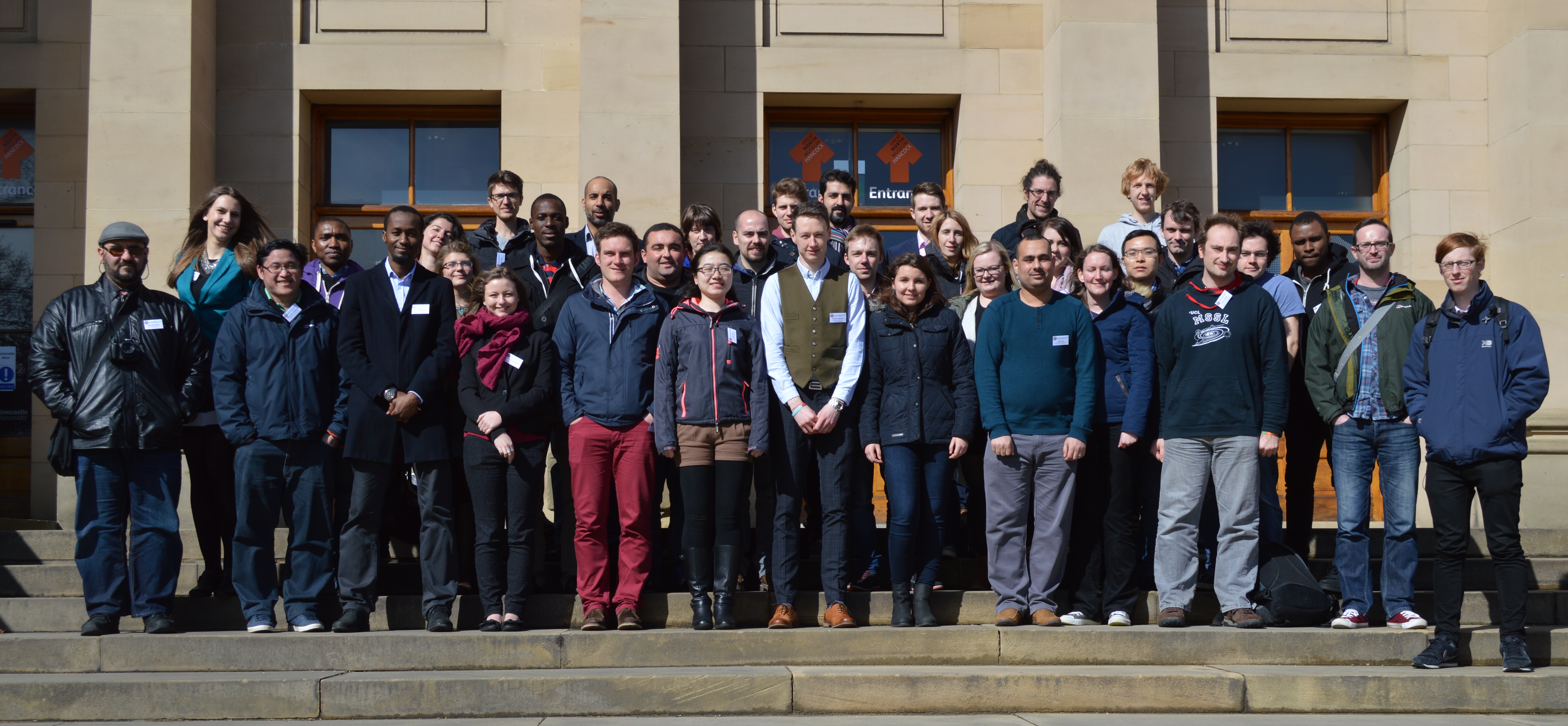
February 9th and 10th was the third of what has become an established annual event for Ordnance Survey (OS); inviting all sponsored PhD and postdoc researchers to present their latest research at the Ordnance Survey head office in Southampton. Whilst many know OS mainly for their paper maps, there is a wide range of research that is being undertaken to keep OS at the forefront of mapping technologies. This diversity in research was presented over the two days in four themed sessions. The opening session was ‘3D’ and was opened with my research on automatic reconstruction from a dense image matching dataset. Other 3D research presented included automatically adding texture maps and semantic information to 3D building models (Jon Slade, Cardiff University), why people need 3D (Kelvin Wong, University College London) and real-time urban dataspace modelling (Oliver Dawkins, University College London).
As well as giving oral presentations, a panel session was held at the end of each session where the session’s presenters and OS employees working in the relevant field were asked questions on the overriding theme of the session. This generally led to some really interesting and insightful discussions about how the panel saw the discussed research fitting into the OS remit. It also became apparent that parts of the research presented in the session as well as the other session had several overlapping themes, opening the opportunities for future collaboration. A poster session was also held after lunch each day which allowed OS employees who may not be directly involved with the research to view what studies are currently being undertaken, whilst giving the authors an opportunity to network and discuss their results.
The final session of day one was themed ‘Data Analysis’. The first two presentations from Robin Frew, University of South Wales, and Rebecca King, University of Southampton, addressed spatial usability issues and temporal modelling, respectively. The final two speakers of this session were first year PhD students presenting an overview of their research; Nick Bennett, University of Southampton, and Judit Varga, University of Nottingham, will be investigating similar topics in the use of data mining to map events and update mapping at different scales.
The second day opened with the theme of ‘People and Places’, the social sciences side of Ordnance Survey research. This covered a wide range of research included mapping vernacular geographies (Katherine Stansfeld, Royal Holloway, University of London), how people identify with narratives and place (Iona Fitzpatrick, University of Nottingham) and how different users interact with geo-spatial technology (Mike Duggan, Royal Holloway, University of London).
To close the workshop the final session theme was ‘Machine Learning’. Presenters Ce Zhang (Lancaster University) and postdoc David Young (University of Southampton) discussed their research utilising deep learning for supervised and unsupervised image classification.
As well as giving us the chance to see the various research projects undertaken by OS as well as getting to see our external supervisors, it also gives the chance to see how fellow PhDs are progressing through their projects and share an tips or advice of how to overcome the next hurdle. As I am now approach the writing up stages of my research, this will unfortunately be my last OS PhD workshop. I would therefore like to take this opportunity to thank Ordnance Survey for the data supplied and their continuing support throughout the progression on this research.
From Monday 30th March till Wednesday 1st April, the department hosted the annual Remote Sensing and Photogrammetric Society (RSPSoc) Wavelength Conference. Since it’s rebranding from the student conference, which was last hosted in Newcastle nine years ago, young professionals are now also welcome to present their research and latest developments in all aspects of remote sensing and photogrammetry. The conference was organised by third year PhD student, Andrew McClune, whose research is focussing on the automatic reconstruction of 3D building models from aerial photography.
The conference was well attended by approximately 40 delegates, mainly from UK institutes but with some travelling from as far as Nigeria and Turkey especially for the conference. A wide range of research topics were presented. The opening session was dedicated to the research of dust & gas detection from satellite platforms, before second year PhD student Magdalena Smigaj, presented her work entitled ‘’Remote sensing for UK forest health monitoring” in the first of the two vegetation sessions. The final session of the first day was a keynote session given by the International Society of Photogrammetry and Remote Sensing (ISPRS) Council members, who were in the area for an ISPRS Council meeting. Chen Jun opened with an introduction to the society before Christian Heipke, Leibniz Universität Hannover, and Marguerite Madden, University of Georgia, discussed their individual research topics “New approaches for automatic classification or aerial and satellite images” and “Geospatial Information Supporting Animal Movement and Habitat Studies”, respectively. The final day was closed with a meal at Blackfriars Restaurant, where ISPRS Council members and delegates continued to network and discuss research.
The conference prides itself on offering a strong scientific and social programme, with Tuesday morning being designated to the first batch of social activities. Whilst a small group went to battle it out over the annual game of laser quest, a local tour guide led the rest of the delegates around the many scenic delights that Newcastle has to offer. Although the weather did not hold up with a heavy downpour encountered mid-tour, the tour gave an insight into the history development of the city. The tour started along the Quayside visiting the many bridges along the river before working their way back to the University via the castle, Grainger market and Grey’s Monument.
Presentations resumed after lunch with the urban management topic which saw presenters from GetMapping UK present their street level imagery dataset and the online GIS platform for local parish councils, as well as the use of historical imagery for assessing planned urbanization. The second oral session of the day saw the second vegetation session of the conference and included the winner of Best Oral Presentation from Emily Norton, from Bournemouth University for her research entitled “Multi-Temporal remote sensing of mass graves in temperate environments”. She was proudly presented with a remote sensing book, kindly donated from sponsors Taylor & Francis.
A wide range of poster were presented towards the end of the second day with second year PhD Elias Berra discussing “Forest phenology monitoring by unmanned aerial vehicle” and first years Ben Grayson and Fikiri Mhenga presenting their proposed PhDs researching “Digital photogrammetric techniques in aid of UAV trajectory determination” and “Using remotely sensed products for improved hydrological models in high mountain hydrological regimes.” The final session of the second day was a sponsor session, where representative from Sterling Geo presented the latest developments of the ERDAS software suite whilst promoting the CHEST agreement, which entitles universities to purchased licences for the software at a heavily reduced price.
The second day finished with a meal on the Quayside before the second social event of the conference which saw delegates go bowling. For some it was their first time and they either took to bowling like a duck to water or were experiencing some beginners luck.
The final day was opened with a session dedicated to disaster management and prevention, which saw Maria Peppa and Polpreecha Chidburee, both second year Newcastle PhDs presented their individual PhD research topics entitled “Development of a UAV-based landslide monitoring system” and “Development of a low-cost, real-time photogrammetric monitoring system for landslide hazard analysis”. This was followed by a session of data integration before the conference was closed with a keynote address from David Holland, Ordnance Survey, presenting research on the creation of 3D datasets, a topic which he has been supervising Andrew on as part of his PhD.
A big thank you to the staff and PhD students that helped in the organisation and success of the conference, as well as Edward Malina from the Mullard Space Science Laboratory, part of University College London. Edward will now become the Wavelength Rep for RSPSoc and will now start to organise the next Wavelength conference in 2016.
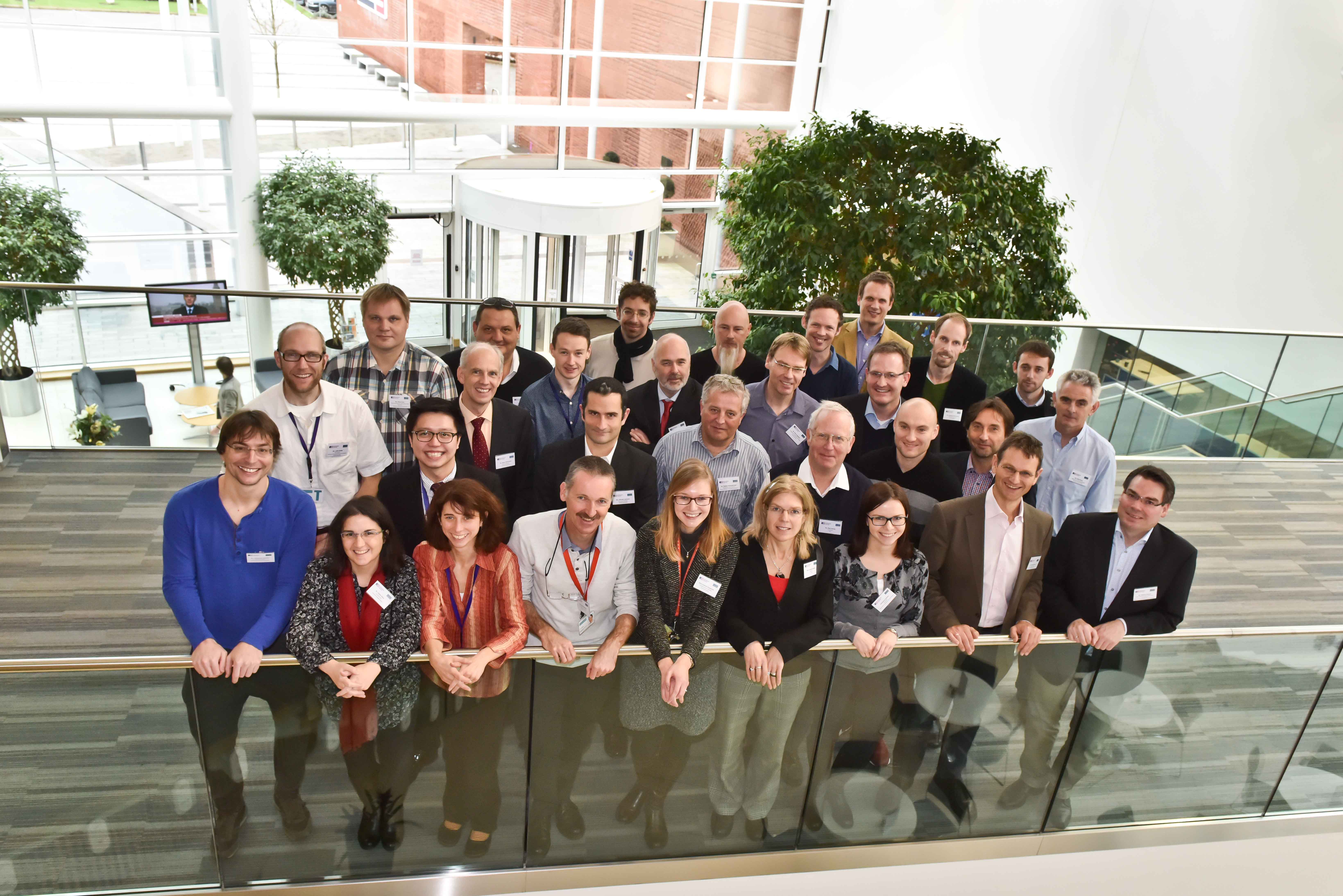
Last Thursday and Friday (27th – 28th November) saw the joint European Spatial Data Research (EuroSDR) and International Society of Photogrammetry and Remote Sensing (ISPRS) ‘Workshop for capturing national scale 3D models’. Hosted at Ordnance Survey, Southampton, the workshop brought national mapping agencies, industry vendors and research scientists together to discuss all things 3D including the storage of 3D data (Hans Veihmann, Oracle) and making building models look more realistic with automatic texturing (Gerald Forkter, UVM Systems Gmbh).
Several presentations were given through the duration of the workshop, including those from the three Ordnance Survey funded PhD students focusing on 3D modelling. Firstly, Jon Slade, Cardiff University, presented methods of adding semantic and geometric information to a 3D model using imagery from repositories such as Flickr. I then presented my research on automatic 3D reconstruction from multi-ray photogrammetry, with the slides available here. Kelvin Wong, University College London, presented some preliminary results of an experiment to determine which parts of buildings people look at whilst navigating to determine what users may require from 3D models.
Examples of where national scale 3D models have been implemented were presented. Sander Oude Elberink, University of Twente, presented a case study of how part of his PhD research is being implemented by the Dutch Kadaster. Building footprints are extruded to a height calculated from lidar point clouds to produce a 3D national dataset. Height are also applied to roads, bridges and water bodies. Similar work is being undertaken by Ordnance Survey, presented by Isabel Sargent, by applying height attributes to OS MasterMap building footprints for the base of the building and various parts of the roof. This is currently available as an alpha release. Other research being undertaken includes automatic classification of roof structures using machine learning and clustering, as well as the research being undertaken by the PhD students listed above.
A series of breakaway groups were formed during the workshop to discuss matters such as the management of 3D data, what 3D editing tools need to be applicable, and the best approach to creating 3D models: whether this be developed from existing 2D datasets or to start data capture and production as a new process. Whilst no formal answers were concluded, these matters are to be further discussed and developed as part of the special interest group (SIG) and presented at the next workshop meeting, to be held in March 2015. One topic is to determine what are the potential economic benefits of national and regional 3D models by answering the following questions;
What is defined as a regional or national dataset? What is defined as 3D?
What added value does a national or regional 3D dataset have over local and project-based datasets?
What are the economic benefits of 3D data, if any, gained from this level of extended coverage?
What business opportunities can be realised through the application of 3D data at a national level?
Beyond technical challenges, what are the additional problems that NMAs face at this level of coverage?
This research is being fronted by Kelvin Wong, who requires participants to undertaken a short interview. If you would like to take part in this research please email kelvin.wong.11@ucl.ac.uk.
Thanks go to Rollo Home and Jantien Stoter for the hosting and organisation of the workshop. The points raised in this workshop led to many discussions and opinions, which hopefully may become closer to being solved by the next meeting in March 2015. Information on the SIG can be found at http://www.eurosdr.net/research/project/eurosdr-special-interest-group-3d-3d-sig
Photo of the delegates from the EuroSDR 3D workshop at Ordnance Survey, Southampton
After a brief stop at the RSPSoc conference, Andrew McClune took the long journey from Aberystwyth to Zurich for the ISPRS Commission III midterm symposium entitled ‘Photogrammetric Computer Vision’ (PCV), which was held and organised by ETH Zurich in conjunction with the European Conference on Computer Vision (ECCV) 2014. With there being a large overlap between many photogrammetric tasks and the applicability of computer vision approaches, this was a perfect opportunity for academics and industries to present and discuss research on many topics including machine learning, artificial intelligence, robotics, photogrammetry and geosciences.
With Zurich known for its lavish lifestyle with a vast amount of expensive hotels, accommodation was offered by the organisers in one of Zurich’s luxurious air bunkers. These offered an ideal location being close to the city centre and the free transport passes for delegates meaning getting to and from them was a breeze. Whilst the beds and the facilities were not the most accommodating, it gave the opportunity for young researchers from all over the world to meet and discuss their research.
Accommodation was very kindly provided by the event organisers
Over 150 international delegates attended the three day PCV conference from 5th September. After an address from ISPRS general secretary, Christian Heipke, a series of oral presentations were given on stereovision and building reconstruction. Keynote presentations came from Andrew Davison, of Imperial College London, presenting work on SLAM and Michael Goesele, of TU Darmstadt, who presented photogrammetric reconstruction of real world scenes. Other technical session during the conference included scene interpretation, pose estimation and performance evaluation. During the poster session Andrew presented work on extracting and integrating data from multi-ray photogrammetry for 3D building reconstruction. A copy of Andrew’s Poster can be viewed on the following link.
Of the attendees at PCV, 60% took advantage of the reduced conference rates and also attended ECCV, where more than 1400 delegates were in attendance. ECCV started with a series of workshops on the 6th and 7th September where keynote speakers presented sessions on various topics including UAVs, scene analysis and object tracking. The conference officially opened on the 8th September. Whilst keynote addresses were presented in the workshops, the following four days of the conference saw over 350 posters and nearly 40 oral presentations. The main topics of focus were face detection, human pose estimation, and segmentation of RGBD imagery as well as some more abstract work including smart car headlights and using computer vision to measure the carbohydrate content in a meal. One oral session focussed on Structure from Motion (SfM), which is becoming very popular in photogrammetry, and several posters presented research using SfM for the registration and 3D reconstruction of Flickr based images, real-time mobile imagery and videos. Many companies were also in attendance to discover the latest research and also present how computer vision was being used within industry for dentistry, visual simulation with detected humans as well as many UAVs based projects including Amazon’s UAV delivery service. ECCV was drawn to a close on the 11th September with a short presentation from next year’s organisers in Amsterdam, before a final day of workshops.
The annual RSPSoc conference was held from the 2nd till the 5th September at Aberystwyth University. In attendance from Newcastle University were School Research Fellow Dr Pauline Miller and 2nd year PhD student Andrew McClune, who both presented on their own projects. Whilst the title of the conference was ‘New sensors for a changing world’, a large variety of research was presented over the three days from mass grave detection to using citizen sensor data to classify remotely sensed imagery.
The first day of the programme consisted of four workshops: lidar processing using high performance computing; the habitat inventory of Wales; an RSPSoc UAV special interest group (SIG) meeting; and a NERC Field Spectroscopy Workshop. The UAV SIG meeting was attended by Pauline, who is involved in a number of UAV research projects at Newcastle. This meeting was held jointly with ARPAS-UK (Association of Remotely Piloted Aircraft Systems), and provided a good opportunity for the academic community to interact with industry representatives from a number of UAV service sectors. The workshop was centred around debate on some highly topical issues, including how to optimise the quality of scientific UAV sensors, and aspects surrounding legislation and licensing. Overall, it provided an excellent forum for academia-industry discussion, and will hopefully be a forerunner for similar future meetings. An ice breaker reception was held on the evening of this first day at the National Library of Wales, with the opportunity to visit the Dylan Thomas exhibition and view the impressive map collection which consists of over 1.5 million maps (though there was not enough time to get round them all!).
The second day saw the official opening of the conference with a keynote session from Dr Susan Brown of Winrock International, who spoke about measuring carbon stocks in tropical forests. Pauline chaired the first morning session on Image-Based Measurement Techniques and Applications, and also presented her research on the use of photogrammetric approaches for measurement of multi-decadal Antarctic glacial mass change. The afternoon started with another keynote address from Dr Masanobu Shimada from the National Space Development Agency of Japan before technical sessions on LiDAR and REDD+. The second day was concluded with a steam train journey along the Vale of Rheidol railway, sponsored by Newcastle PhD student Mitko Delev’s company Bernard Geomatics, to Devil’s Bridge for some refreshments.
Picture of the front of the stream train which took delegates to Devil’s Bridge, with the journey sponsored by Bernard Geomatics
The third day started with Dr Richard Lucas delivering a keynote presentation regarding sensor interoperability in the context of new sensors. Technical sessions covered a wide range of topics from landslides and mass movement to observations and impacts of fire and ice. A diverse range of topics were also presented in the poster session, where Andrew presented his work on 3D building reconstruction from aerial photography. The conference dinner and award ceremony was held in the evening and the recipient of the best doctoral thesis award was Newcastle Geomatics graduate Dr Matthias Kunz (2014), for his research on ‘Elevation changes of mountain glaciers in the Antarctic Peninsula using ASTER-controlled archival aerial photography.’
For those still standing after the previous night’s ceilidh, Professor Mark Danson provided the final keynote session entitled ‘Laser spotlight on forest structure’ before the final series of technical sessions on landcover and landuse and UAVs, which brought the conference to a close for another year.
Overall the conference was a resounding success and a great platform for the RSPSoc 2015 conference, hosted in Southampton, to build upon.
From the 14th to the 16th April the annual RSPSoc Wavelength conference, aimed at students and young professionals to present their work to their fellow peers in an informal environment, was hosted among the quaint hills of Great Malvern, Worcestershire.
I was given the pleasure of opening the conference with a presentation on the work I have been undertaking on automatic 3D city modelling. This was followed by presentations on change detection, archive stereo imagery and forestry applications from various remote sensing satellites. Other presentations during the conference included the use of UAV and structure from motion, atmospheric correction of remote sensing data and the fusion of imagery and lidar.
During the three days keynote speakers included Dr Alastair Graham of Geoger Ltd, Dr Matthew Blackett from Coventry University and Professor James Brasington from Queen Mary University, who all gave invaluable advise of skills and abilities needed to progress during these early steps of research. A consistent theme mentioned by all was the need to be able to write software via different programming languages. A good historical overview was given by all of how data capture, storage and processing has changed. This was also the first year that a sponsor session was held allowing sponsors to present what their respective companies do and how our work fits into these remits. Simon Mears from Leica Geosystems presented some of their recent hardware, particular the Aibotix UAV which was on display, and software developments. Dr Andy Wells from Sterling Geo gave a good overview of the developments of the ERDAS Imagine software and linked this to the topics that had already been presented that day.
The always popular poster session saw a wide range of topics being presented from mass grave detection to how soil moisture content change can be detected. The sessions was almost dominated by Newcastle University with posters presented by first year PhD students Polpreecha Chidburee, Maria Peppa, Magdalena Smigaj, Elias Berra, who presented work on how they intend to undertaken their individual research projects, and Mitko Delev, who presented work undertaken as part of his masters project on using photogrammetry for structural gauging in a railway environment. A poster was also presented by undergraduate student Cedric Meyer who presented his dissertation work on the potential for bio-physical information retrieval.
As well as having a strong scientific program , several social activities were also offered including high pole activities, a trip to Worcester and a guided walk around the hills of Great Malvern. Luckily the sun shone all week, which made the walk much more enjoyable. An evening activity of laser quest was well attended with individuals battling it out to become the ultimate champion. With many references being made about laser scanning and how a scanner could be set up in the arena to make it even harder, it is fair to say I will never look at laser quest in the same way. Drinks were enjoyed at the end of both days allowing delegates to discuss their research work further as well as taking the opportunity to talk to the sponsors and keynote speakers.
A huge congratulation goes to Amy Woodget of Worcester University for organising such a successful conference. As I am about to take over as RSPSoc Wavelength Representative and start to organise next year’s conference here in Newcastle, I hope to build on the success on this year’s conference as well as show everybody what a vibrant city Newcastle is and what it has to offer.
Monday 3rd till Tuesday 4th March saw the introductory lectures held for the 12th EuroSDR EduServ e-learning course at the University of Trento, Italy. Located just south of the Alps, the city sits in the Adige Valley so is surrounded by snow-caped mountains to give a picturesque view. The lectures were attended by a small delegation, mainly from national mapping agencies and universities from across mainland Europe. The four courses of the EduServ programme were introduced and presented by the various course leaders over the two days.
View from Bruno Kessler Foundation, Trento University
On the first day Professor Norbert Haala, of Stuttgart University, started proceedings and presented material for his course on high density imaging matching. He presented some of the results of DSM creation from different software packages as part of his EuroSDR benchmark on image matching, whilst giving an overview of the Semi-Global Matching (SGM) algorithm, which I am using as part of my PhD, It was shown how a dense point cloud can be created from UAV and aerial photography by using the SGM approach. Hopefully this workshop will give greater insight and help overcome issues that have been experienced with ‘noisy’ photogrammetric point cloud.
Afterwards Dr Petri Ronnholm, of Aalto University in Finland, presented his course on the integrated use of airborne laser scanning and aerial photogrammetry. This was again based around a EuroSDR benchmark which tested different methods for the integration of the two dataset, some of which will be used in the course. The lecture was concluded with an interactive session to discuss the advantages and disadvantages of integrating the two dataset and what future applications this could be used for. One point that arose and was discussed was whether there was a need to integrate the two datasets due to high density point clouds being created from imagery, by the principles outline previously by Professor Haala. It was concluded that although lidar is still essential for forestry application, research may prove that photogrammetric point clouds are just as suitable as lidar for other applications.
A meal was held after the first day’s lectures at a local restaurant in Trento, with exquisite pasta and other traditional Italian food enjoyed over four courses and wash down with a glass (or two) of local wine. This offered a great ice breaker and a way to get to know other delegates as well as the course leaders.
Dr Clement Mallet, of IGN France, started the second day by presenting material for his course on change detection in high-resolution land-use/land-cover geodatabases and presented work from his EuroSDR benchmark regarding change detection methods. The need for land cover and land use was introduced followed by many different approaches presented, which mainly used satellite imagery.
Dr Daniella Poli, of Terra Messflug GmbH, closed proceedings with the last of the four courses on mapping using high-resolution satellite imagery. An insightful overview was given of low resolution film-based satellites to new high resolution digital-based sensors as well as the processing that is required for processing the data. This carried on from some of the principles covered by Dr Mallet, giving more details on the processing that may be required in order to use satellite imagery including radiometric corrections and Rational Polynomial Coefficients.
Thanks to Fabio Remondino of Trento University for hosting an excellent introductory workshop. With the first course starting today (10th March) and the final course finishing on the on the 13th June it is hope many new skills will be learnt over the next four months.
The last two weeks saw the World Geospatial Forum, Rotterdam and the ISPRS Hannover Workshop where the latest research and commercial activities in photogrammetry and remote sensing were presented.
Only attending the final day of the World Geospatial Forum meant a chance to attend the Technology Forums. These consisted of presentations from commercial vendors such as Leica Geosystems, RIEGL and Optech showing their latest hardware and software developments as well as universities and research institutes presenting their work. The final session of the day, entitled ‘3D – the next challenge for national mapping agencies’, presented how methods developed in research were being utilised by the Dutch national mapping agency for the reconstruction of buildings at the Level of Detail 2, in accordance with the CityGML standard. Although a very commercial conference some resources were sourced for the research into automated 3d building reconstruction.
After a nice weekend trip to Köln enjoying the sights and the sunshine, the ISPRS Hannover Workshop about High-Resolution Earth Imaging for Geospatial Information began. Talks included data collected from space all the way down to the bottom of the ocean for various applications. Across the four days keynote presentations were given by Rainer Sandau of DLR in Berlin who spoke about how space collected data can be used for disaster management and the integration of data, Lorenzo Bruzzone from Trento university spoke about the challenges and trends of multitemportal imagery and Charles Toth, the current ISPRS Commission 1 president, spoke about the different platforms available for data collection. The final keynote was Michael McCullagh from Nottingham University who spoke, a little off topic, about crowd source data. Several interesting examples were given, some closely related to the Twitter work undertaken by Newcastle whilst presenting a website (www.ushahibi.com) for a non-profit company promoting open-sourced data.
Research institutes and universities presented their current research which led to many discussions being carried on in the coffee breaks. Newcastle’s Abdulhamed Gneeniss presented his PhD work on the integration of photogrammetric and lidar data for aerial triangulation and camera calibration alongside several other young researchers, presenting in both oral and poster formats. Two poster sessions portrayed varying amounts of research including UAVs, GPS solutions and building detection from differing sourced data.
The conference’s main sponsors, Hexagon, gave a master class in the new hardware and software they have developed. After a brief overview of the company’s history, the company’s new large-format and medium format cameras were presented as well as their new oblique camera systems. The software included their photogrammetric software developed by tridicon, which included semi-global matching algorithms for point cloud generation from aerial imagery as well as automated 3D building reconstruction.
Social activities included an ice-breaker evening on the rooftop of the Leibniz Hannover university’s Institute of Photogrammetry and Geoinformation and the conference dinner at the Wilhelm Busch Museum where extravagant buffets were laid with some nice local beer to taste. These gave a great opportunity to discuss in further detail the research presented in the day and way to get to know people.
Thank you to Christian Heipke and the team at Leibniz Hannover University for organising such a captivating conference.