Keynote speech at Futurs Urbains conference

CESER Director, Richard Dawson, delivered a keynote speech at the international Futurs Urbains conference in Paris this week.  Richard delivered a talk that introduced CESER’s innovative Urban Integrated Assessment Facility and then reflected on lessons learned in London and Durban on the process of integrated modelling.  This included consideration of the technical challenges of modelling, the extent to which they meet policy needs, role of stakeholders in model development and application, barriers to their uptake and the value of and effort required for integration.

One key issue for teams embarking upon an integrated assessment must realise is that it does not provide all the answers or ‘design variables’ BUT it does stimulate the conversations and interactions that are needed to drive forward climate adaptation and mitigation agendas.

Although integrated assessment, in urban areas and elsewhere, comes at extra effort, Richard concluded that it was worthwhile – indeed essential for many of the world’s sustainability challenges because it enables teams to develop a collective understanding of policies concerning multiple pressures, urban functions and stakeholders.  Of course, there remain many challenges – not least transferability of these sophisticated modelling systems and communicating their results to wide audiences.

Better soil management is key to improving our resilience to extreme floods and droughts

Dr Paul Quinn speaks to BBC Radio 4 about Newcastle University’s efforts to improve our resilience to the extreme weather events of 2012

Senior Lecturer in Catchment Hydrology and CESER researcher, Dr Paul Quinn was invited to take part in a special programme for BBC Radio 4’s Farming Today on extreme weather conditions in 2012. The programme aired on Jan 2nd, and is currently available via the BBC iPlayer.

Paul was involved, alongside Farming Consultant Lindsay Hargreaves and a number of farmers from across the country, to discuss their experiences and understanding of drought and floods last year, and consider what 2013 might bring. The unusually dry winter (in England and Wales) preceding Spring 2012 led to a severe drought in the first months of the year and the resulting hosepipe ban in March. Across the border in Scotland, however, was a very different situation, with 2011 being the wettest on record for 100 years and no signs of let up into 2012, where some parts actually received less than average rainfall for the latter part of the year!

In England, the hosepipe ban became a somewhat ironic prelude to what turned out to be the wettest summer since records began, and the accompanying cold temperatures alongside the sheer amount and longevity of rainfall completely devastated crops nationwide including cereals, potatoes and fruit. Individual farmers speaking on the BBC programme reported losses of between 15% (potatoes) to 90% (apples) on the previous year, not to mention the knock-on effects of such a late, low quality harvest; namely barns full of grain blocking cattle coming in for winter and further wet/icy conditions making removal of that grain impossible.

The solution for farmers to such extreme weather (which we know under conditions of climate change will most likely increase), is better soil management, according to Paul. He explains that our soil is generally in a poor state, so does not store as much water as it used to. This is due to overuse and the fact that modern farming practices often don’t allow the soil to function properly. Paul, alongside other members of CESER and the NIReS Terrestrial Theme at Newcastle University, believe that it is possible to create a climate resilient landscape that results in positive relationships between food production, soil and water management, biodiversity and habitat protection, pollution reduction and even carbon storage. This requires collaboration between specialists in different fields (pardon the pun!), something which is being made possible through CESER and the NIReS Terrestrial Theme, and will result in more opportunities for research into catchments and landscapes with multiple functions that are more resilient to the changes in climate that we are witnessing in the UK but also globally, as described on the programme.


New analysis of London’s urban heat island

New work by CESER researchers has demonstrated how a long temporal baseline of daytime AVHRR data can be employed to capture the summer temperature regime of the city of London, UK, including the response to a known heatwave event.

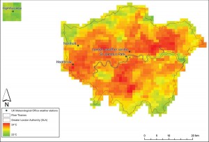
AVHRR scene of estimated surface temperature (EST) of Greater London, 8 August 2003, 14:04 (GMT), showing the location of London weather stations employed in the study and the rural reference site relative to London.

Analysis of Advanced Very High Resolution Radiometer (AVHRR) data for London shows the high degree of spatial variability of intensity of urban heat across London. Furthermore, it is highly sensitive to local meteorological effects and daily cycles.

Comparison of the Urban Heat Island Intensity (UHII) [the maximum difference between urban and rural temperatures during one day] in a statistically robust manner showed that the 2003 heatwave UHII data sets for both image surface and ground air temperatures did not exhibit significantly greater intensities than the other years under consideration.  This is in contrast to other work on this topic (e.g. Cheval et al., 2009; Tomlinson et al., 2010) that indicates that not only is the UHII metric a relatively poor means by which to distinguish between a heatwave summer in London, but also the need for further scrutiny of the use of the UHII.

The full paper can be downloaded by following the link:
Holderness, T., Barr, S.L., Dawson, R.J. and Hall, J.W. (2013) An evaluation of thermal Earth observation for characterising urban heatwave event dynamics using the urban heat island intensity metric, Int. J. Remote Sensing, 34(3):864–884

Please contact Stuart Barr for more information.