Infrastructure Asset Management themed issue ‘Climate Change – Part 1’ FREE to download #ibuild @TyndallCentre @nclceser

The following papers recently published in a ‘Climate Change’ themed issue of Infrastructure Asset Management are available to download for free for the next four weeks.

This edition is the first of a two part series edited by Professor Richard Dawson.

#ceser #water Three fully funded PhD studentships are available within the Water Resources Engineering Group

Three fully funded PhD studentships are available within the Water Resources Engineering Group in the School of Civil Engineering and Geosciences at Newcastle University, sponsored by Science Agriculture and Engineering Faculty Doctoral Training Awards.

The Water Resources Engineering Group is a leading centre for research into climate and catchment modelling, and development of advanced hydroinformatics, risk analysis and decision support tools. These are used internationally to tackle the complexities of coupled technological, human and natural systems and enable practical responses to the challenges of intensifying global change.

Each Doctoral Training Award is for £20,000 per annum. This award is sufficient to cover home(UK)/EU fees and a contribution to an annual stipend (living expenses). Applications will be considered as they are received, until 18th August 2014 or sooner if the awards are made before this date.

Further details on each studentship are given below, including contact details for further information, and links to the Newcastle University website with details on how to apply.

Vulnerability of shallow groundwater and surface water resources used for irrigation in rural communities in Sub-Saharan Africa to climate variability and change.

Reference Code:           CI701.

Contact:                        geoff.parkin@ncl.ac.uk.

Link:                             http://www.ncl.ac.uk/postgraduate/funding/search/list/ci701

There is abundant groundwater in Africa; more than 100 times the annual renewable freshwater resource and 20 times the amount of freshwater stored in lakes, but its productive use in sub-Saharan Africa (SSA) remains low. Globally, abstraction of groundwater increased tenfold between 1950 and 2000 and contributed significantly to growth in irrigation, particularly in Asia. Rapid expansion of groundwater use may also be about to occur in SSA, to support dry season irrigation used to enhance traditional rain-fed agriculture. Given the constraints of lack of technical and financial resources to drill into deeper aquifers, development of groundwater resources is easier to achieve in shallow aquifers. However, shallow aquifers are more vulnerable to climate variability, particularly to recurrent droughts or delays in the onset of wet season rainfall, due to their limited capacity as a groundwater store.

The research aims to carry out multi-scale assessments related to the impacts of climate variability and change across sub-Saharan Africa, to identify the key factors, particularly climatic but also including hydrogeological constraints, agricultural water potential demand, patterns of demand from crop choices, methods of irrigation, and land use within watershed management programmes, that control vulnerability of shallow groundwater resources used by rural communities for irrigation. Based on analysis of large-scale climatic patterns and water management practices, appropriate mathematical models of integrated groundwater-surface water systems will be developed at multiple scales, and used with statistical methods to assess vulnerability of shallow groundwater resources for a range of scenarios of climate and resource planning.

The use of long term climatic data takes places mainly at national and regional levels, influencing large scale policies. This PhD will include some visits to selected SSA countries for interaction with governance as well as technical institutions in order to understand the current and potential use of climatic data in decision-making. This contextual understanding will help to enhance the practical use of the research and to produce policy recommendations.

The PhD study is closely allied with an existing research project funded by NERC, ESRC and DfID, working in Ethiopia, Ghana and South Africa. A further proposal to extend this work over at least the period of the PhD study is being submitted. If successful, the student will be fully integrated into this research programme, which will offer further opportunities for in-depth field visits working with local communities.

We aim to recruit an ambitious numerate student who has the aptitude and interest for analysis of large datasets and use of advanced modelling techniques for climate and hydrological/hydrogeological assessments, together with an interest in application in a developing countries context. The student will be expected to liaise with our partners in Ethiopia and other African countries, in particular the International Water Management Institute and the Geological Survey of Ethiopia. Candidates would typically be expected to be educated in an undergraduate degree in a numerate discipline (e.g. engineering), with an MSc/MRes in a relevant applied discipline such as water resources management, or an undergraduate degree in environment or earth sciences with a relevant numerate MSc/MRes degree.

Will catchment scale afforestation for mitigating flooding significantly reduce water resource availability and productive farmland?

Reference Code:           CI702

Contact:                        james.bathurst@newcastle.ac.uk

Link:                             http://www.ncl.ac.uk/postgraduate/funding/search/list/ci702

The 2013-14 winter floods in the UK have led to calls to afforest the uplands to reduce future flooding. However, the role of forests in flood reduction remains controversial. Further, the proportion of a catchment that would need to be forested to have a significant impact on downstream flooding, and the amount of farmland that would be correspondingly lost, have yet to be defined. Water resources could equally be reduced by the additional forest evapotranspiration. The study will therefore examine the hypothesis that catchment afforestation programmes can significantly reduce downstream flood hazard without significantly reducing water resource availability or productive farmland. Both headwater catchment plantation (affecting flood frequency and magnitude) and riparian plantation (to attenuate flood wave movement in the floodplain will be considered).

Study objectives include the impact that upstream afforestation can have downstream at the full catchment scale, the proportion of a catchment and the parts of a catchment that need to be afforested to have a significant downstream impact and the extrapolation of the results to a potential full UK programme. An integrated field and modelling approach will be followed, in which the field study ensures a foundation on firm experimental evidence while the modelling provides the means to extrapolate from the necessarily limited field data and to generalise applicability. The effects of afforesting headwater catchments will be investigated using Newcastle University’s leading physically-based catchment modelling system SHETRAN. The relevant field evidence will come from an existing paired grassland/forest catchment experiment in the Irthing catchment (Cumbria) headwaters while the full catchment will form the basis for simulations investigating the scale and spatial distribution issues. The impact of riparian forest will be modelled using a powerful new hydrodynamic modelling framework, developed at Newcastle University, that fully exploits modern graphics and central processing units. The relevant field evidence will come from existing experimental studies in Northumberland into the use of instream large wood debris structures and riparian plantation to attenuate flood wave movement. A recently developed framework for applying SHETRAN at the UK scale will provide the basis for simulating the impact of catchment afforestation on flood response at the national scale. An important output will be benefit in flood reduction as a function of the area and location of land required to be afforested to achieve that benefit, compared with the associated reduction in water resource availability and loss of farmland. Stakeholder involvement will ensure focus on practical and applied outcomes and provide a pathway for achieving impact. The study is highly relevant to the social issue of flooding while also providing an opportunity to examine in detail the scientific controversy over the impact of forests on floods within the context of a potential large-scale application.

Applicants should have a 1st class or high 2.i first degree or a MSc with at least a high merit pass (65+). Relevant degrees include environmental science, geography, engineering and mathematics. Applicants should be willing to carry out field work in remote areas of northern England in all weathers; for this it would be helpful to have an appropriate driving licence. They should be numerate, have an aptitude for computer modelling and be fluent in English, including writing.

Attribution of climate risks in urban areas for the design of adaptation pathways

Reference Code:           CI700

Contact:                        richard.dawson@newcastle.ac.uk

Link:                             http://www.ncl.ac.uk/postgraduate/funding/search/list/ci700

Climate related risks are usually a function of multiple weather, socio-economic and engineering factors.  This is particularly acute in urban areas where these three dimensions are tightly coupled and highly dynamic.  Attribution of risk, decomposes its constituent elements to enable decision-makers to better target investment to manage risk.  Methods of attribution are emerging for global scale analysis, providing useful information for global greenhouse gas mitigation.  But these methods are not suited to local scale attribution of risk, and prioritisation of investment in adaptation strategies to reduce climate related risks.  This PhD will address this challenge through development of a range of analytical approaches to decomposing the constituent factors of climate risk at the urban scale.

The ideal candidate would be:

  • from an engineering, mathematical or physical science background,
  • proficient in statistics, computational analysis and modelling,
  • knowledge of climate change and adaptation issues,
  • able to communicate with urban planners and infrastructure owner/operators, and,
  • capable of writing up their work for academic and stakeholder audiences.


Greening Wingrove project: “When Water Engineers Meet Gardeners”

Claire Walsh and Mark Powell are currently working with the Big Lottery funded, Greening Wingrove community partnership project.  This was established to encourage the people of Wingrove Ward (Newcastle) to ‘green’ their local area and explore more sustainable ways of living.

While much of Claire and Mark’s work has centred on exploring ways to evaluate the project’s success, they have also helped organise workshops that showcase CEG research, especially around flooding. The most recent workshop took place on Wednesday evening of last week, when CEG PhD student Eleanor Starkey presented at a local community event entitled, ‘When Water Engineers Meet Gardeners.’

This workshop was designed to showcase civil engineering approaches to managing urban flood risk and using models, illustrate the potential impact of extreme flood events on both the local Wingrove area and Newcastle City more generally. Eleanor revealed that while Wingrove is not an area particularly badly affected by floods, water runoff from this part of the city significantly impacts on other areas. Eleanor presented a reconstruction of the 2012 ‘Toon Monsoon’ and introduced the concept of Sustainable Drainage Systems (SuDS) and their possible multiple benefits. These measures not only slow down the speed of storm water runoff, which benefit the city as a whole, but also provide local householders with a water supply for use in the garden.

While encouraging individual households to keep a single water butt might appear to offer only minor benefits for larger flood management strategies, this might also encourage a more general interest in gardening and a cultural shift in how individuals choose to engage with their environment.

However, many Wingrove residents live in terraced properties with concrete yards, and therefore have limited access to land suitable for planting and growing.  One challenge for the Greening Wingrove Project is to encourage residents living in these areas to also take up the greening philosophy.  In an effort to identify new planting opportunities, Mark Ridsdill Smith has been running a series of project workshops on how to grow using containers and window boxes.  According to Mark, who writes a column in The Guardian on ‘Vertical Veg,’ a major problem for container growers is securing a reliable water supply. Installing a water butt for gardening use not only reduces costs it also makes for a much speedier watering operation. During the workshop, Mark demonstrated how to build different forms of water reservoir and irrigation systems, all fed from a water butt connected to domestic guttering down-pipe

http://www.theguardian.com/lifeandstyle/2014/mar/14/container-gardens-mark-ridsdill-smith

Eleanor and Mark Ridsdill-Smiths’ presentations revealed how installing a water butt in Wingrove has the potential to provide a range of interdependent benefits.  The water butt not only forms part of a Sustainable Drainage Systems (SuDS), it also offers a ready-made solution to the problem of container growing.  By encouraging local people to cultivate plants and enjoy the greening of previously concrete yards, the Wingrove Project seeks to generate new environmental perceptions and engagements that will have citywide benefits. To find out more about the Greening Wingrove project visit http://greeningwingrove.org.uk/ 

#ceser #ibuild Matt Holmes wins best presentation at the IWA’s UK conference for Young Water Professionals

holmes 099055077STREAM PhD Student Matthew Holmes won the best presentation prize at the IWA’s UK conference for Young Water Professionals which was held at the University of Manchester, 23-25 April. The theme of the conference was, ‘What is smart?’, Matt’s presentation, ‘Resilient Infrastructure: Do loosely-coupled dependencies mediate the risk of cascading failure?’ covered his PhD work in collaboration with United Utilities, Severn Trent Water and Yorkshire Water. Congratulations Matt!

Matt is currently in the final year of the PhD STREAM Programme and is sponsored by United Utilities. STREAM is the Industrial Doctoral Centre for the Water Sector funded by the Engineering and Physical Sciences Research Council (EPSRC) and companies who sponsor research projects. For more information about STREAM visit: http://www.stream-idc.net/index.php 

Newcastle Launch: Infrastructure BUsiness models, valuation and Innovation for Local Delivery

iBUILD is a £3.5m programme, funded by two UK research councils, following a request in the 2011 National Infrastructure Plan.  The programme is led by Professor Richard Dawson at Newcastle University. www.ibuild.ac.uk

iBUILD focuses on local and urban infrastructure, and in line with this, is establishing Centre hubs in Newcastle, Leeds and Birmingham.  These hubs will lead a series of events to explore alternative business models and the opportunities within these cities and their surrounding regions.

The Newcastle iBUILD Centre is holding a launch event on Wednesday 20 November from 3pm to 6pm at the Newcastle Business School on the Science Central Site.

The event will include a brief introduction to the research programme, discussion around how you can get involved with the project at a number of levels and identifying local priorities and case studies. There will also be presentations from Edward Twiddy (NELEP) and Andrew Lewis (Newcastle City Council).

If you would like to register to attend please complete the following form:  http://forms.ncl.ac.uk/view.php?id=5004 .

SHOCK Project Dissemination Event

SHOCK (NOT) HORROR is an EPSRC-funded project that, over the past two years, has been looking at how ‘shock’ events can provide opportunities for learning about and transformation of infrastructure systems.

On Friday 22 November (10am to 4pm) we will be holding our final project dissemination event at The Royal Society in London. The event will include an overview of the project process, methodologies and findings. Interactive sessions will draw upon a number of  activities and experiments that the project has conducted to prompt discussion around identifying barriers and enablers for change and innovation of infrastructure systems. A final open discussion on the value of this research and its outcomes, alongside other on-going research programmes will aid identification of future research priorities.

If you would like to register to attend please complete the following form:  http://forms.ncl.ac.uk/view.php?id=5061. Please feel free to circulate the attached project information flyer to others who may be interested in the event.

A more detailed programme will be available nearer the time of the event.

What an Asteroid Belter!

As part of the British Science Festival 2013 being hosted at Newcastle University, researchers, staff, lecturers and students were invited to contribute to a comic being developed and designed by local comic enthusiasts. The comic was officially targeting children between the ages of 8-13, with a view to promoting STEM subjects and science in general. The proposed content of the comic had, you guessed it, a distinctly scientific theme to it, with organisers interested in hearing from those staff members who could fit their work (or at least make it look like their work fits) in to one of the following themes:

  • Robots
  • Explosions and danger
  • Dinosaurs
  • Space, time and travel
  • Very big and very small things
  • Things we eat, and things that eat us
  • Codes, ciphers and hidden messages
  • Heroes and villains
  • Matters of life and death

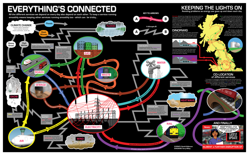
Some of the work related to networks, connectivity and infrastructure that is currently being conducted within the context of the Infrastructure Transitions Research Consortium (ITRC – www.itrc.org.uk) and also within the School of Civil Engineering and Geosciences, seemed like something that kids could be interested in, and the idea of presenting this type of work within a comic context offered an alternative and novel mechanism for communicating our research. Once an expression of interest in contributing to the comic had been lodged, it was simply a case of meeting an artist and writer assigned by the organising committee, and beginning to think about what a comic to represent networks, connectivity and infrastructure should look like! In fact, largely due to the expertise and imagination of the artist I had been assigned (Terry Wiley), the ideas began to come together, and rather than stick to the traditional panel-based approach we decided on more of a spider diagram affair to communicate how different bits of infrastructure are connected together. However I still wish we had managed to get our idea of slightly transparent paper with networks hidden until the page was held up to the light, to fly to communicate the idea of hidden or non-obvious connections! Oh well, maybe next time. For all those interested, the comic, entitled “Asteroid Belter”,  in hard copy format was distributed at the British Science Festival 2013 (7th-12th September), but more information about it can be found here.

Post by David Alderson

Students flood to measure the BlueLine

The hosting of the British Science Festival 2013 by Newcastle University gave staff and researchers of the School of Civil Engineering and Geosciences a chance to “show off”  some of their research to the general public, whilst also gave the opportunity to generate interest in science, technology, engineering and maths (STEM) subjects via hands-on activities delivered to school children from the North East. One such activity, named “BlueLine”, organised and delivered by Dr Geoff Parkin (Senior Lecturer in Hydrology), Professor Hayley Fowler (Professor of Climate Change Impacts), Dr Vedrana Kutija (Lecturer in Computational Hydraulics), Dr Claire Walsh (Researcher in Water Resources), Mr Vassilis Glenis (Researcher in Water Resources), Mr Philip James (Senior Lecturer in GIS), and Mr David Alderson (Researcher in GeoInformatics), focussed on explaining the complex nature of flooding and extreme flooding to separate groups of secondary school children from local schools in the North East. The schools represented are listed below:

–          Shotton Hall Academy, Peterlee

–          Berwick Academy, Berwick

–          Ponteland High School, Ponteland

–          Thomas Hepburn School, Felling

The sessions began with Dr Parkin delivering a brief summary of some of the causes of flooding and extreme flooding, citing many references that relate to flood events experienced in recent years within the UK, including those that occurred in Cumbria in 2005, Tyne and Wear in 2008 and 2012, and many others. However that was just the standard “in-class” part of the activity, and although the seminar generated interest from the students in such topics as the water cycle, climate change, global warming, and the impacts of flooding, the “really” interesting part came when the children were let loose outside on the University campus, to take part in a crowd-sourcing exercise.

Crowd-sourcing in it’s most simple terms involves members of the public contributing data, information, comments, stories, pictures etc, which are then subsequently used within some form of analysis. Within the School of Civil Engineering and Geosciences, there has been a concerted effort since the flooding in a local market town, Morpeth, in 2008, by water and geomatics researchers and lecturers alike to collect as much crowd-sourced based information about flooding and flood events that occur within the region. The contributions from the general public about the locations and timings of floods, alongside photography giving a reasonable indication of flood depths, levels and wrack lines, can be used to validate computer simulations of flood models, developed within the School. Some of the results of these crowd-sourcing endeavours can be found here.

So the purpose of crowd-sourcing in the context of flooding was explained to the students in attendance at the Blueline event, and how it can be used to help better understand how a flood propagates through different environments. Since the floods in 2008 and 2012, Philip James has developed an Android-compatible “app” that helps to facilitate this process, by allowing a user to use the location technologies within an Android device (tablet, smart phone etc) to locate themselves, and then subsequently use the camera to take a picture. The great thing about the app is that this data can then be sent to a server and published immediately onto a website, giving a near-real time record and subsequent archive of a flood event. As stated, this type of data is invaluable to understanding how a flood arises and then subsides. For more information about the app and the technologies employed to deliver this solution, have a look here.

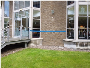
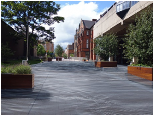
So the school children were escorted outside where a “pretend” flood had been erected around Newcastle University campus (effectively just a line of blue tape indicating a flood level based on a particular amount of rainfall), and asked to use the app and a tape measure to record information about the depth of this “flood”. This seemed to go down a storm (sorry) as it offered them a chance to do all the things that children seemingly would rather be doing i.e. being outside and playing with technology! Each pairing were asked to try to record at least one reading at each point where we stopped around campus. Further to this a series of QR codes had been erected along the blue line that the students were able to scan, subsequently directing them to a site of historical photography of the flooding that occurred on campus in 2012, as well as some “constructed” imagery of the imaginary flood that they were measuring. For more information on this site and the photos, please follow this link.

Post by David Alderson

   
The “BlueLine” around campus, denoting an imaginary flood level The reconstructed flood represented by the “BlueLine”

@BritishSciFest CESER researchers at the British Science Festival

This week the British Science Festival is being held in Newcastle. CESER researchers are involved in a number of activities:

  • David Alderson and Hayley Fowler have both contributed to the Newcastle Science Comic. David worked with Terry Wiley to produce ‘Everything’s Connected’ and Hayley with Adam Murphy on the ‘Climate Change and Extreme Weather’ comic strips. Asteroid Belter – The Newcastle Science Comic will be launched at Newcastle City Library on Saturday 7th September, 9.30am-5.30pm.
  • In recent months, Claire Walsh has been working with artist Adam Chodzko who has produced a podcast about climate change and flooding in the region. Adam was commissioned by Invisible Dust and Great North Run Culture to produce a piece which will be launched on Saturday 7th September at the Tyneside cinema. Adam’s podcast, ‘Rising’ can also be heard here.
  • Following on from the launch of ‘Rising’, arranged by Invisible Dust, Claire Walsh and PhD student Liz Lewis will be working alongside four local artists on Sunday 8th September in the grounds of St Thomas’ church near the Haymarket. From 12-6pm, members of the public can take part in art and craft activities to depict and visualise climate change issues and impacts.
  • On Wednesday 11th September at 2pm, Professor Hayley Fowler will deliver the Joseph Lister Award Lecture, ‘What’s happening to our weather’. The event  is being held at the Northern Stage. This lecture will discuss what causes different types of extreme flood events and whether this is increasing based on the latest evidence.
  • Throughout the festival on campus look out for our ‘blue line’. The ‘Blue Line’ project was set up to illustrate how extreme weather conditions can affect urban areas such as the Newcastle University campus, and how we can use computer models and data to help design sustainable solutions to reduce flood risk. The Blue Line illustrates possible flood levels from an extreme rainstorm, and the arrows show the main flow directions.An activity using the blue line is taking place during the young person’s programme running from Monday to Thursday. Find out more here or contact Geoff Parkin.

Luke Smith: best paper by a young author at the International Conference on Flood Resilience #ICFR

Luke Smith won best paper by a young author at the International Conference on Flood Resilience held at the University of Exeter this week. Luke’s paper, ‘A flexible hydrodynamic modelling framework for GPUs and CPUs: application to the Carlisle 2005 floods’ built upon his MSc dissertation project. Luke has just completed the first year of his PhD, ‘High-resolution hydraulic modelling of flood attenuation features in catchments’,co-supervised by Dr Qiuhua Liang and Dr Paul Quinn. Earlier this week Luke also had his first international journal paper accepted by Computers and Fluids. A great week, well done Luke.