i-BUILD: Infrastructure BUsiness models, valuation and Innovation for Local Delivery

EPSRC and ESRC have recently announced the funding of i-BUILD, a £3.5M research centre, led by Professor Richard Dawson at Newcastle University, to develop new approaches to infrastructure business models with the ultimate aim of replacing current public-private business models that in many cases provide poor value.

While national scale infrastructure plans, projects and procedures set the wider agenda, it is at the scale of neighbourhoods, towns and cities that infrastructure is most dense and interdependencies between infrastructures, economies and society are most profound – and hence the focus of our activity will be at these local and urban scales.  Balancing growth across regions and scales is crucial to the success of the national economy. The Government’s response (March 2013) to Lord Heseltine’s review of local economic growth emphasised the devolution of funding for local major infrastructure schemes that is occurring from 2015, the importance of the development of an integrated approach to local infrastructure investment and also noted the requirement for alternative funding models. This localism agenda is encouraging local agents to develop new infrastructure related business but this is limited by the lack of robust new business models with which to do so at the local and urban scale.

To develop a new generation of business models the i-BUILD research programme is structured around three main research streams:

(i)   Reducing the costs of infrastructure delivery by understanding interdependencies between systems and alternative finance models;

(ii)  Improving the way we value the wider benefits of our infrastructure by identifying and exploiting the social, environmental and economic opportunities; and,

(iii) Reconciling local scale priorities with regional and national strategic needs – because no locality is disconnected from its surroundings.

New approaches developed through these research streams will be tested and demonstrated on integrative case studies in partnership with an extensive stakeholder group from academic, private, public and voluntary sector organisations. 

An official launch event will take place on the 7th June.  Details to follow.

About the i-BUILD team:
The i-BUILD Centre brings together a highly integrated and multi-disciplinary team embracing many of the UK’s leading researchers in infrastructure engineering, business modelling, economic analysis and social science, alongside an extensive stakeholder group.  The Centre will have its headquarters at Newcastle University (Director: Professor Richard Dawson, CESER; Deputy director: Professor Andy Pike, CURDS) in collaboration with leading academics from the University of Birmingham (Deputy directors: Professor Chris Rogers; Professor John Bryson) and the University of Leeds (Deputy directors: Professor Phil Purnell; Professor Andy Gouldson). 

About the Newcastle team:
i-BUILD draws together expertise in civil engineering, urban economy, business models and societal engagement from four schools at Newcastle University: the School of Civil Engineering & Geosciences, the School of Geography, Politics and Sociology, Newcastle University Business School and the School of Agriculture, Food and Rural Development

The full i-BUILD team can be found here:
http://gow.epsrc.ac.uk/NGBOViewGrant.aspx?GrantRef=EP/K012398/1

Adaptation and Resilience in Cities: Final dissemination event

Adaptation and Resilience in Cities: Analysis and decision making using integrated assessment (ARCADIA)

Final dissemination event, 2 May, London

Building upon work developed during the Tyndall Centre Cities Programme, the ARCADIA project has developed a methodological approach for looking at risks to urban systems, understanding the inter-relationships between climate impacts, the urban economy, land use, transport and the built environment, has enabled the testing of adaptation options to design cities that are more resilient. The final dissemination event will be held on Thursday 2 May, 1-5pm, at the Friend’s Meeting House, Euston Road, London. During the event, key messages from the project will be presented using the example impacts of urban heat and flood risk. There will also be more detailed presentations and demonstrations of the project’s methodological approaches: spatial weather generator, economic modelling, land-use and transport modelling.  During the event we will welcome your review, evaluation and potential use of the tools, methodologies and research outcomes that will be showcased.

To register to attend please email Claire.Walsh@ncl.ac.uk   by Tuesday 30 April.

Using Twitter to understand football supporting patterns

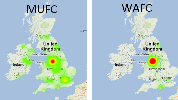
The location of the football team that you support is often a cause for debate, with chants like “we support our local team” being heard on the terrace week in week out. And now with the influx of football fans taking to twitter to support their teams this provides another way of measuring this metric.

As a group the idea of using twitter to crowd source the location of events is not a new one. Previously we have used it to record flood events across the north east allowing for a real time map to be produced. An idea which will be used heavily in the forthcoming iTURF project (integrating Twitter with Realtime Flood modelling).

Developomg a football script it was simply a matter of applying our previously developed scripts to record the locations of tweets related to football teams. Here, the official hashtag for each team and then simply recorded the club, location and time, the actual body of the tweet is not stored.  With the script in place data feeds into a database and a webpage displaying the tweets in real-time which is available here


The data can also provide hotspots showing key areas of support for each team, predictably some show more spread than others.

More details, including analysis of average distance from homeground are reported on the Geospatial team’s webpages.

Geospatial team Open Source contribution recognised

The Geospatial group within CESER are offically an OSGEO lab, and thus part of a growing number of universites globally to hold such a title. Only those universities and departments which can showcase extensive work, skills and experience in the use of open source tools and software for geospatial related research are awarded the title. The title/gorup comes after a  memorandum of understanding was signed between the Open Source Geospatial Foundation (OSGeo) and the International Cartographic Association (ICA) in 2011. For more information on the memorandum, follow this link

As part of becoming a OSGEO lab, we have also developed a new website to showcase our related work. This can be found at http://research.ncl.ac.uk/osgeolab/

For further information on this announcement, see the press release which can be found on our blog at https://blogs.ncl.ac.uk/geospatialengineering/2013/01/08/newcastle-geospatial-engineering-part-of-the-osgeo-labs-for-research-and-education/

CESER Research featured on BBC Radio 4 Today programme

Prize winning research by CESER Director Richard Dawson (see article here) was featured on BBC Radio 4 in a short piece that remembers the 1953 flood event – 60 years on.

Professor Robert Nicholls, long time CESER collaborator and co-author of the research, describes some of the research and the difficulties associated with managing a dynamic coastline.

The featurette starts at 1:21:08-1:26:00 (with a later interview of 1953 survivors)

http://www.bbc.co.uk/iplayer/episode/b01q95ry/Today_31_01_2013/

Keynote speech at Futurs Urbains conference

CESER Director, Richard Dawson, delivered a keynote speech at the international Futurs Urbains conference in Paris this week.  Richard delivered a talk that introduced CESER’s innovative Urban Integrated Assessment Facility and then reflected on lessons learned in London and Durban on the process of integrated modelling.  This included consideration of the technical challenges of modelling, the extent to which they meet policy needs, role of stakeholders in model development and application, barriers to their uptake and the value of and effort required for integration.

One key issue for teams embarking upon an integrated assessment must realise is that it does not provide all the answers or ‘design variables’ BUT it does stimulate the conversations and interactions that are needed to drive forward climate adaptation and mitigation agendas.

Although integrated assessment, in urban areas and elsewhere, comes at extra effort, Richard concluded that it was worthwhile – indeed essential for many of the world’s sustainability challenges because it enables teams to develop a collective understanding of policies concerning multiple pressures, urban functions and stakeholders.  Of course, there remain many challenges – not least transferability of these sophisticated modelling systems and communicating their results to wide audiences.

Better soil management is key to improving our resilience to extreme floods and droughts

Dr Paul Quinn speaks to BBC Radio 4 about Newcastle University’s efforts to improve our resilience to the extreme weather events of 2012

Senior Lecturer in Catchment Hydrology and CESER researcher, Dr Paul Quinn was invited to take part in a special programme for BBC Radio 4’s Farming Today on extreme weather conditions in 2012. The programme aired on Jan 2nd, and is currently available via the BBC iPlayer.

Paul was involved, alongside Farming Consultant Lindsay Hargreaves and a number of farmers from across the country, to discuss their experiences and understanding of drought and floods last year, and consider what 2013 might bring. The unusually dry winter (in England and Wales) preceding Spring 2012 led to a severe drought in the first months of the year and the resulting hosepipe ban in March. Across the border in Scotland, however, was a very different situation, with 2011 being the wettest on record for 100 years and no signs of let up into 2012, where some parts actually received less than average rainfall for the latter part of the year!

In England, the hosepipe ban became a somewhat ironic prelude to what turned out to be the wettest summer since records began, and the accompanying cold temperatures alongside the sheer amount and longevity of rainfall completely devastated crops nationwide including cereals, potatoes and fruit. Individual farmers speaking on the BBC programme reported losses of between 15% (potatoes) to 90% (apples) on the previous year, not to mention the knock-on effects of such a late, low quality harvest; namely barns full of grain blocking cattle coming in for winter and further wet/icy conditions making removal of that grain impossible.

The solution for farmers to such extreme weather (which we know under conditions of climate change will most likely increase), is better soil management, according to Paul. He explains that our soil is generally in a poor state, so does not store as much water as it used to. This is due to overuse and the fact that modern farming practices often don’t allow the soil to function properly. Paul, alongside other members of CESER and the NIReS Terrestrial Theme at Newcastle University, believe that it is possible to create a climate resilient landscape that results in positive relationships between food production, soil and water management, biodiversity and habitat protection, pollution reduction and even carbon storage. This requires collaboration between specialists in different fields (pardon the pun!), something which is being made possible through CESER and the NIReS Terrestrial Theme, and will result in more opportunities for research into catchments and landscapes with multiple functions that are more resilient to the changes in climate that we are witnessing in the UK but also globally, as described on the programme.


New analysis of London’s urban heat island

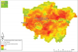
New work by CESER researchers has demonstrated how a long temporal baseline of daytime AVHRR data can be employed to capture the summer temperature regime of the city of London, UK, including the response to a known heatwave event.

AVHRR scene of estimated surface temperature (EST) of Greater London, 8 August 2003, 14:04 (GMT), showing the location of London weather stations employed in the study and the rural reference site relative to London.

Analysis of Advanced Very High Resolution Radiometer (AVHRR) data for London shows the high degree of spatial variability of intensity of urban heat across London. Furthermore, it is highly sensitive to local meteorological effects and daily cycles.

Comparison of the Urban Heat Island Intensity (UHII) [the maximum difference between urban and rural temperatures during one day] in a statistically robust manner showed that the 2003 heatwave UHII data sets for both image surface and ground air temperatures did not exhibit significantly greater intensities than the other years under consideration.  This is in contrast to other work on this topic (e.g. Cheval et al., 2009; Tomlinson et al., 2010) that indicates that not only is the UHII metric a relatively poor means by which to distinguish between a heatwave summer in London, but also the need for further scrutiny of the use of the UHII.

The full paper can be downloaded by following the link:
Holderness, T., Barr, S.L., Dawson, R.J. and Hall, J.W. (2013) An evaluation of thermal Earth observation for characterising urban heatwave event dynamics using the urban heat island intensity metric, Int. J. Remote Sensing, 34(3):864–884

Please contact Stuart Barr for more information.

Prize winning research: The coastal conundrum – balancing the costs of erosion v flooding

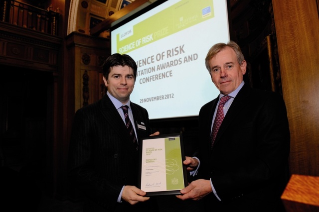
Richard Dawson receives the prize from Richard Ward, Lloyds Chief Executive (photo courtesy of Lloyds)

CESER Researchers have won the Lloyds Science of Risk prize in the Climate Change category for their work on risk modelling in the coastal zone.


The coastal conundrum – balancing the costs of erosion v flooding

Ensuring continued flood protection for low lying coastal areas may mean sacrificing cliff top communities to the sea, experts reveal.

A study [click here for publication] carried out by scientists from the Tyndall Centre for Climate Change Research[ii],[iii], and today awarded the 2012 Lloyds Science of Risk prize[iv] for Climate Change research, shows how the benefits of protecting our coastline from erosion must be balanced against the impacts of coastal flooding.

Focussing on a 72km stretch of shoreline along the East Anglian coast, the team detail the interconnection between the two risks of erosion and flooding and show that in some cases, allowing natural erosion could reduce the impact of flooding associated with rising sea levels.

Richard Dawson, Professor of Earth Systems Engineering at Newcastle University[v], lead author of this study says the research – which will be further developed in a new book to be launched in Spring 2013[vi] – highlights the trade-off between shoreline management policy and other priorities.

“We know that sea levels are rising and will continue to do so over the 21st Century, what we don’t know is by exactly how much, or how fast,” he explains.
“That means we need flexible strategies in place so that we are ready whatever the climate throws at us in the future.  These strategies must be coordinated and recognise the large scale connectivity of coastal processes – such as the movement of sand along the coastline.

“Given pressures of rising sea levels and large coastal populations, coupled with increased pressure on finances, it seems unlikely we will be able to afford to protect every stretch of coastline.  Land will be lost to the sea so we’re going to have to make difficult decisions about what our priorities are.”

Coastal defences put in place by Victorian engineers over a century ago have re-shaped the UK coastline, artificially protecting some areas but at the expense of beaches in adjacent areas.

This man-made situation increases the risk of flooding in low lying coastal settlements where beaches act as a natural flood defence.  Beach levels can be artificially recharged but Professor Dawson says maintaining this indefinitely along large stretches of coastline is likely to be unsustainable.

“Coastal areas typify the environmental challenge our society faces – their beauty and economic opportunities attracts settlement and they include some of our most important ecosystems and most productive farmland. Yet this exposes us to hazards such as erosion and flooding which will be exacerbated by sea level rise.

“Clearly we can’t, and wouldn’t want to, remove all our sea defences but there are difficult tradeoffs to be made in prioritising coastal management measures.

“Our research provides a common platform to get all parties round the table – local residents, policy-makers, insurers, scientists and farmers to name but a few – to understand each other’s perspectives, discuss potential compensatory arrangements, and collectively decide the best way forward.”


[i] “Integrated analysis of risks of coastal flooding and cliff erosion under scenarios of long term change” by Richard Dawson, Mark Dickson, Robert Nicholls, Jim Hall, Mike Walkden, Peter Stansby, Mustafa Mokrech, Julie Richards, Jian Zhou, Jessica Milligan, Andrew Jordan, Stephen Pearson, Jon Rees, Paul Bates, Sotiris Koukoulas, Andrew Watkinson. Climatic Change, Vol 95 pp249–288 (2009). http://www.ncl.ac.uk/ceser/researchprogramme/publications/integratedanalysisofrisksofcoastalfloodingclifferosionunderscenarios.html

[ii] The Tyndall Centre for Climate Change Research is an active and expanding partnership between the Universities of East Anglia (headquarters), Cambridge, Cardiff, Manchester, Newcastle, Oxford, Southampton, Sussex, and recently Fudan University in Shanghai. It conducts research on the interdisciplinary aspects of climate change and is committed to promote informed and effective dialogue across society about the options to manage our future climate.

[iii] This research was part of the Tyndall Centre coastal programme and was funded by the Natural Environment Research Council (www.nerc.ac.uk), the Engineering & Physical Sciences Research Council (www.epsrc.ac.uk) and the Economic and Social Research Council (www.esrc.ac.uk).  Professor Dawson, Professor Hall and Professor Nicholls co-lead the Tyndall Centre’s Cities and Coasts research theme.  www.tyndall.ac.uk

[iv] The paper won the 2012 Lloyds Science of Risk prize in the Climate Change category:
http://www.lloyds.com/the-market/tools-and-resources/research/exposure-management/emerging-risks/the-science-of-risk

[v] Professor Richard Dawson is Director of the Centre for Earth Systems Engineering Research (CESER) at Newcastle University.  CESER is an interdisciplinary research centre that addresses the analysis, design, engineering and management of sustainable solutions to address global change (including climate change).

[vi]  “Broad Scale Coastal Simulation: New techniques to understand and manage shorelines in the third millennium”, published by Springer and edited by Professor Robert Nicholls (Southampton University), Professor Richard Dawson (Newcastle University) and Dr. Sophie Day (Southampton University), will update this research and provide further insights into the Tyndall Centre’s coastal research. The book is due for publication in Spring 2013.

RAMSES (FP7) Project funded

RAMSES (Reconciling Adaptation, Mitigation and Sustainable Development for Cities) is a €5m FP7 research programme that aims to develop methods, tools and case studies to design strategies, quantify costs and evaluate the impacts of adaptation to climate change in cities.

The Newcastle team, led by CESER Director Richard Dawson, have received €520k to (i) develop a high level climate risk assessment for European cities, (ii) extend our existing urban integrated assessment modelling to include pluvial flooding, evaluation of impacts on the urban economy of extreme events, and air quality and health issues, (iii) apply (and adapt) our integrated assessment facility for new city case studies – including one international location, and (iv) test a range of adaptation strategies to identify how best to reduce risks in cities and inform the design of transitions to more sustainable urban environments.

The consortium is led by PIK (Potsdam Institute for Climate Research) and includes the LSE (UK), Vlaamse Instelling voor Technologisch Onderzoek (VITO, Belgium), Institut du développement durable et des relations internationales (IDDRI, France), Fundación Tecnalia Research & Innovation (TECNALIA, Spain), Norges teknisk-naturvitenskapelige universitet (NTNU, Norway), World Health Organisation Europe, T6 Ecosystems (Italy), ICLEI Local Governments for Sustainability, The Climate Centre (Belgium), Climate Media Factory (Germany) and Institut Veolia Environnement (France).