AGU 2014 – San Francisco in December

GoldenGate

Immediately prior to Christmas, I was fortunate enough to attend the 2014 Fall Meeting of the American Geophysical Union (AGU) which ran from 15th – 19th December in San Francisco, California. The AGU Fall Meeting is a truly unique experience – the largest earth science gathering on the planet, with 25,000 delegates and a multitude of parallel sessions on an enormous range of topics, from deep ocean science to planetary geology; enormous, hangar-like poster halls with an ever-changing collage of scientific outputs, each one the culmination of months or years of hard analysis (in theory anyway!). Totally engaging, overwhelming, exhausting and inspiring. I was lucky enough to have been awarded an oral slot, and on the Thursday morning delivered a presentation on the results of our ongoing NERC-funded project, ‘The spatial and temporal distribution of 20th Century Antarctic Peninsula glacier mass change and its drivers’ – otherwise known as GCAP20C. Our colleague from the British Antarctic Survey/University of Gloucestershire, Lucy Clarke, was also attending and presented orally on her related work on GCAP20C. Both presentations were well received, and I presented to a sizeable audience in a session dedicated to glacier monitoring using remote sensing techniques. The Newcastle component of the research is quantifying multi-decadal mass changes to a benchmark set of 50 glaciers distributed across the Antarctic Peninsula (AP), exploiting a completely untapped resource of  >30,000 archival aerial images of the AP dating back to the 1940s. By comparing DEMs derived from this archival imagery to present-day ASTER DEMs we are able to quantify mass balance, and gain a clearer understanding of the spatial distribution of historical glacial change across the Peninsula. Alongside a more refined multi-temporal sub-sample of glaciers being analysed by Lucy and BAS, this information is crucially important to allow better calibration of models which predict mass changes into the future, and simulate how this would impact on processes such as sea level change.

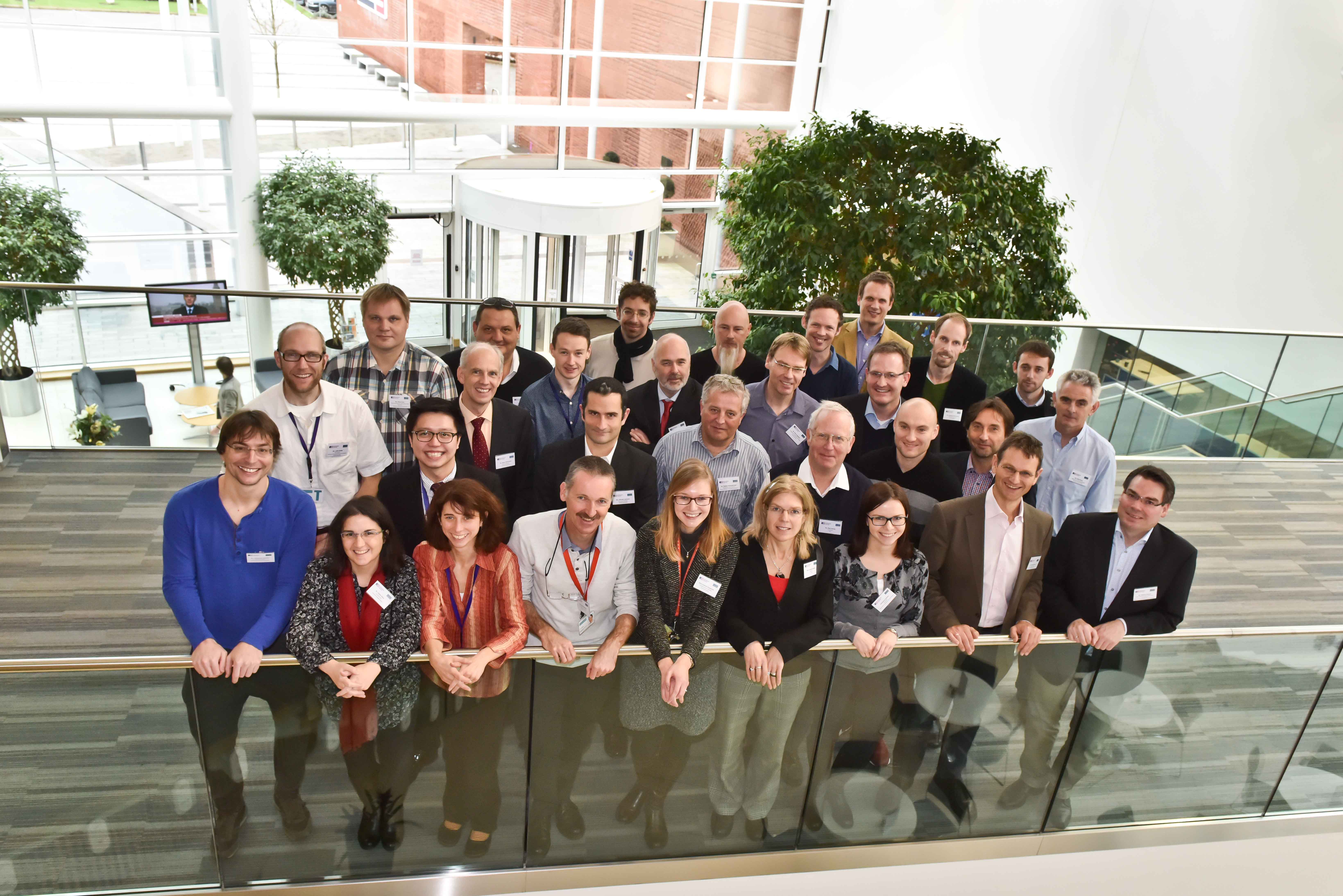
Over the week I caught up with a few former Newcastle colleagues, including Liz Petrie (now a lecturer at Glasgow University, having moved in September 2014), and my good friend Shih-Yuan Lin (also known as Eric) who studied alongside me when we were undertaking our PhDs at Newcastle – pictured below. It was good to see both, and especially Eric, as our last face-to-face get together was a full 6 years ago now, at the ISPRS Congress in 2008.

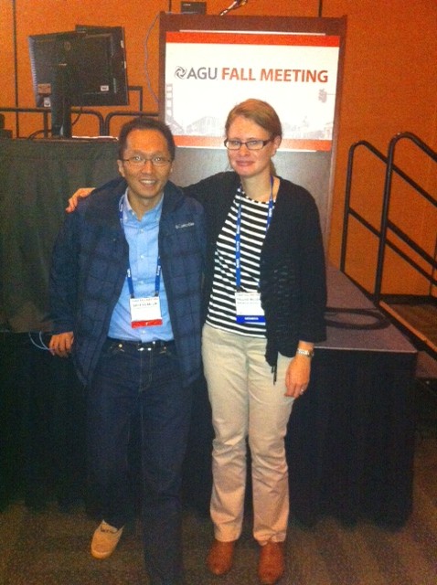
Pauline and Eric at AGU 2014

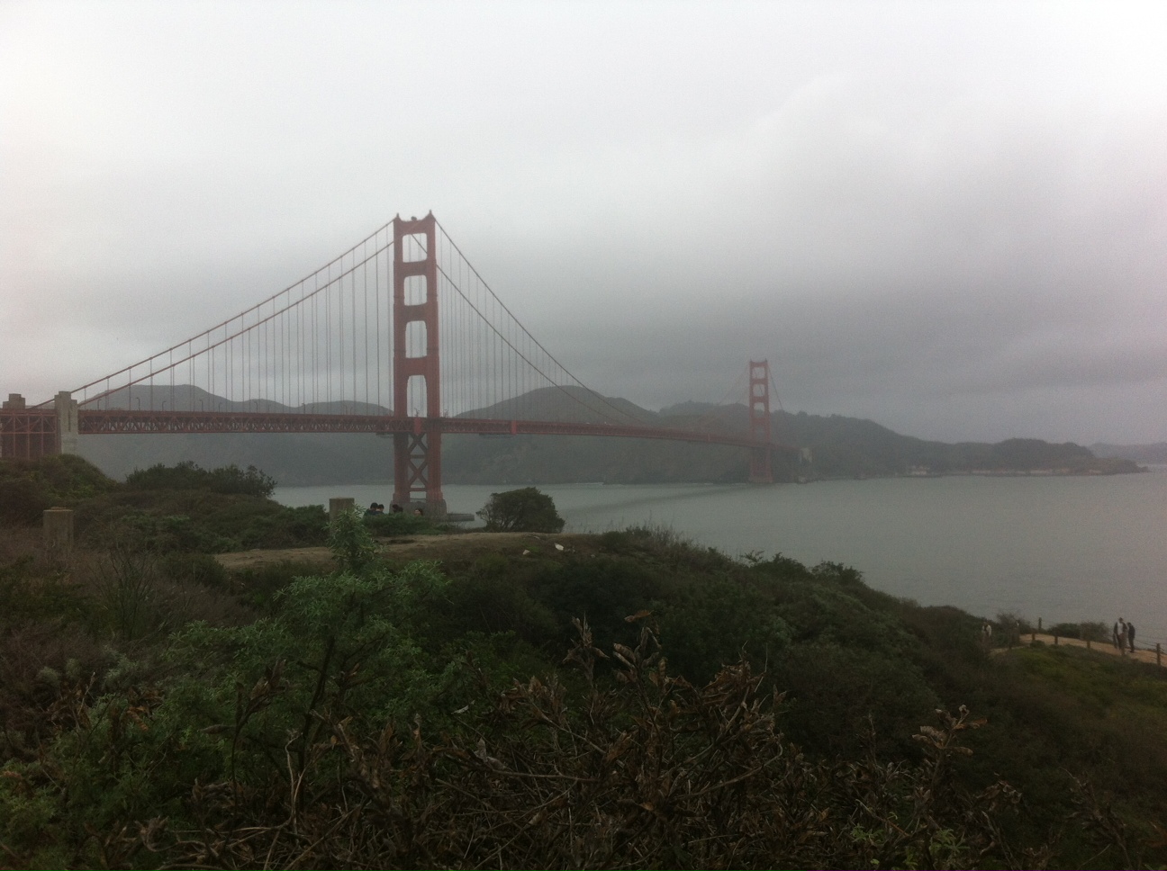
During my only previous visit to the AGU FAll Meeting in 2006, I was unfortunate enough to encounter a week of incessant torrential rain. However, California has been experiencing drought conditions for quite some time, and prospects this year looked more encouraging (for me at least, if not for Californian farmers…). I was hoping for an escape from the cold, icy conditions which had gripped Newcastle in the early weeks of December. Some mild Californian sunshine would have been most welcome. My hopes were dashed however; the grey and misty, but initially dry skies which greeted my arrival at San Francisco International Airport were as good as it got – the rain quickly moved in as the conference got underway, and stayed put for the whole week. Nevertheless, San Francisco is a pretty special place to experience under any conditions, and with my imminent departure from Newcastle to a new job at the James Hutton Institute in Aberdeen, this final trip as an ambassador of Newcastle’s Geomatics group to AGU 2014 will stay with me for a long time to come.

Geospatial in Grenada – Ivan 10

From the 1st – 3rd of December I visited a very sunny Grenada attending the 10th anniversary of Ivan symposium. This looked at the lessons learnt from the fallout of hurricane Ivan across the Caribbean region and how different sectors could help to prevent a future hurricane having a similar affect. I was there representing the CARIWIG project, along with Professor Michael Taylor and Jayaka Campbell from UWI, Jamaica. Michael Taylor brilliantly outlined the project and demonstrated elements of the portal site that I have been putting together over the past year. The presentation was very well received with myself and Jayaka Campbell being asked to demo the storm model element of the portal to a number of delegates.

The CARIWIG portal site is likely to go live following a workshop event in February so watch this space for more details.

storm6
CARIWIG Storm tool

I would like to thank the members of of CDEMA for putting on this event, the conference was well run and contained many interesting talks about hurricane Ivan, including a opening address from the Prime minister of Grenada, as well as plenty of Caribbean food as lunch times. Plus December in Grenada beats December in the north east of England

Whitley Bay eat your heart out

Neil – @neil_py_harris

EuroSDR 3D SIG……. the first of many meetings to come

Last Thursday and Friday (27th – 28th November) saw the joint European Spatial Data Research (EuroSDR) and International Society of Photogrammetry and Remote Sensing (ISPRS) ‘Workshop for capturing national scale 3D models’. Hosted at Ordnance Survey, Southampton, the workshop brought national mapping agencies, industry vendors and research scientists together to discuss all things 3D  including the storage of 3D data (Hans Veihmann, Oracle) and making building models look more realistic with automatic texturing (Gerald Forkter, UVM Systems Gmbh).

Several presentations were given through the duration of the workshop, including those from the three Ordnance Survey funded PhD students focusing on 3D modelling. Firstly, Jon Slade, Cardiff University, presented methods of adding semantic and geometric information to a 3D model using imagery from repositories such as Flickr. I then presented my research on automatic 3D reconstruction from multi-ray photogrammetry, with the slides available here. Kelvin Wong, University College London, presented some preliminary results of an experiment to determine which parts of buildings people look at whilst navigating to determine what users may require from 3D models.

Examples of where national scale 3D models have been implemented were presented. Sander Oude Elberink, University of Twente, presented a case study of how part of his PhD research is being implemented by the Dutch Kadaster. Building footprints are extruded to a height calculated from lidar point clouds to produce a 3D national dataset. Height are also applied to roads, bridges and water bodies. Similar work is being undertaken by Ordnance Survey, presented by Isabel Sargent, by applying height attributes to OS MasterMap building footprints for the base of the building and various parts of the roof. This is currently available as an alpha release. Other research being undertaken includes automatic classification of roof structures using machine learning and clustering, as well as the research being undertaken by the PhD students listed above.

A series of breakaway groups were formed during the workshop to discuss matters such as the management of 3D data, what 3D editing tools need to be applicable, and the best approach to creating 3D models: whether this be developed from existing 2D datasets or to start data capture and production as a new process. Whilst no formal answers were concluded, these matters are to be further discussed and developed as part of the special interest group (SIG) and presented at the next workshop meeting, to be held in March 2015. One topic is to determine what are the potential economic benefits of national and regional 3D models by answering the following questions;

  • What is defined as a regional or national dataset? What is defined as 3D?
  • What added value does a national or regional 3D dataset have over local and project-based datasets?
  • What are the economic benefits of 3D data, if any, gained from this level of extended coverage?
  • What business opportunities can be realised through the application of 3D data at a national level?
  • Beyond technical challenges, what are the additional problems that NMAs face at this level of coverage?

This research is being fronted by Kelvin Wong, who requires participants to undertaken a short interview. If you would like to take part in this research please email kelvin.wong.11@ucl.ac.uk.

Thanks go to Rollo Home and Jantien Stoter for the hosting and organisation of the workshop. The points raised in this workshop led to many discussions and opinions, which hopefully may become closer to being solved by the next meeting in March 2015. Information on the SIG can be found at http://www.eurosdr.net/research/project/eurosdr-special-interest-group-3d-3d-sig

Photo of the delegates from the EuroSDR 3D workshop at Ordnance Survey, Southampton

Andrew McClune
3rd Year PhD Student

International Symposium for Next Generation Infrastructure 2014 Conference, Laxenburg Palace, Vienna, Austria, September 30th-October 1st 2014.

The end of September saw Dr Stuart Barr, Mr Alistair Ford, Mr David Alderson and Mr Craig Robson from the Geospatial Engineering group attend the second International Symposium for Next Generation Infrastructure 2014 conference, this time held just outside Vienna, Austria. All in attendance were either contributors to, or presenters of, papers that had been accepted by the academic committee for the conference. Whilst the proceedings for this year’s conference may not be available just yet, the following presentations were delivered by the team based on the accepted papers:

–          Visualisation tools for multi-perspective, cross-sector, long-term infrastructure performance evaluation (Lead and Presenting Author: David Alderson; Co-Authors: Dr Stuart Barr, Dr Martino Tran (Oxford), Professor Jim Hall (Oxford), Mr Adrian Hickford (Southampton), Mr Edward Byers

–          Simulating impacts of extreme weather events on urban transport infrastructure in the UK (Lead and Presenting Author: Mr Alistair Ford; Co-Authors: Professor Richard Dawson, Miss Maria Pregnolato, Dr Stuart Barr, Dr Katie Young (Oxford), Professor Jim Hall (Oxford)

–          Resilience of hierarchical critical infrastructure networks – (Lead and Presenting Author: Mr Craig Robson, Co-Authors: Dr Stuart Barr, Mr Philip James, Mr Alistair Ford)

For those with a general interest in the overall programme at the conference, please following this link: http://www.ucl.ac.uk/steapp/isngi.

UPDATE (August 2015): Proceedings have now been released.

Whilst attending the conference, the presentation delivered by Dr Roberta Piccinelli from the Institute for the Protection and Security of the Citizen Security Technology Assessment Unit (European Joint Research Centre), was of particular interest. Roberta presented a first-pass approach to model the potential impacts of space weather events on an abstract model of the Finnish electricity network. This was of particular interest to those of us working as part of the UK Infrastructure Transitions Research Consortium (UK ITRC), as it represented an area of study that has not been specifically handled thus far within the consortium i.e. the impact of space weather. To this end, a channel of dialogue between NCL-based researchers and Roberta has been established, with a view to sharing ideas, data and understanding what pure potential there is for collaboration. A link to the paper abstract submitted by Roberta can be found at: https://www.ucl.ac.uk/steapp/isngi/programme/analysisofthevulnerability.

Further to this, Peter Bakker, President and CEO of the World Business Council for Sustainable Development (WBCSD) (http://president.wbcsd.org/about-peter-bakker.html), gave a particularly engaging and “rabble-rousing speech at the close of the first day of the conference. Peter spoke candidly about the deficiencies of the current systems in place to promote and measure sustainability, and particularly highlighted the need to engage with business leaders around the world in relation to promoting sustainability within an infrastructure context.

At the start of the second day of the conference, Professor Bruce Beck from the University of Georgia presented some ideas on using concepts from ecology to understand resilience in cities. In a wide-ranging talk, he examined the resilience of natural systems and considered how similar ideas could be applied to engineered systems (e.g. the idea of flood resilience versus flood resistance – allowing floods to happen but being resilient to them), or allowing systems to learn from small events so they are ready for big ones.

In an interesting parallel to work undertaken by the Geospatial Engineering group as part of the EPSRC ARCADIA project, Simon Blainey from the University of Southampton presented his work with Oxford University on disruptions to the railway network in the UK. Using a simple assignment model based on observed exits and entries to UK railway stations, he showed how the number of journeys on each part of the UK rail system could be estimated. This could then be used to assess the criticality of railway lines in the network and as a basis for understanding ways to increase the resilience of the network. In the ARCADIA project a similar approach was used to examine the possible impacts of extreme heat and rainfall events on transport networks in the UK.

From the first of a number of sessions with the theme of infrastructure and extreme events the work presented by Arthur Peterson on adapting for future flooding events in the Netherlands, was one of a small number which looked at planning aspects for prevention rather than analysing the potential consequences of extreme events. A well-known problem for the European country, the talk addressed how they are looking ahead to prevent flood inundation and the difference in approaches between the recent introduction of the Adaptive Delta Management Plan and that which led to the first set of major works in 1953. It was interesting to see the approaches that have been adopted in establishing a plan where there are significant uncertainties in the available data, e.g. for sea level rise, especially for those who are unfamiliar with this aspect of extreme events.

In the second of the infrastructure and extreme event sessions one of our former researchers, Tomas Holderness, along with one of his new colleagues from the SMART institute, Etienne Turpin, gave a talk on the work they have been carrying out in relation to actively reducing the consequences of flooding due to monsoons in Jakarta, Indonesia (http://petajakarta.org/banjir/en/). In a unique presentation for a number of reasons, they together presented the framework they have established based on the social media platform Twitter, a way in which in real time not only authorities can be informed where and when flooding is occurring in real time, but also allows the public to see the same information and avoid the flooded areas, potentially saving lives, with the biggest killer being electrocution from the water. It was refreshing to see some research where the application was in real-time with lives being saved as a direct consequence instead of a scenario based set of action plans.

GIScience – Vienna

Craig Robson made the trip to Vienna for the 8th GIScience conference, hosted by the Technical University of Vienna (TU). This four day conference, showcasing some of the leading research in the science of geographic information, consisted of a day of workshops and three days of presentations, a poster session and a panel session. Sessions covered a whole host of topics from work related to landcover/use, use and issues of user generated data, spatial analysis and many other areas (see here for programme). The varied nature of the session themes highlights not only the interdisciplinary aspect to the conference, but also the GI science field in which we find ourselves in.

During the conference a number of talks were of particular interest, including a talk on “Detecting Origin-Destination Mobility Flows From Geotagged Tweets in Greater Los Angeles Area”,  which talked about how using tweets from twitter commuting patterns could be mapped for a large area, such as Los Angeles, similar work to that done by Neil Harris for Tyne and Wear (a precursor to the work Craig was presenting).  As well as this a talk on how we can map population distributions, using mobile phone call data, where it is possible to map the shift between weekdays and weekends as well as during holiday periods of the population distributions. The talk used an area of northern France as an example, including Paris, where significant trends, such as shift away from Paris and towards the coast could be seen for example at weekends during the summer as well an increase around tourist locations such as Disneyland Paris. There are too many talks which were of interest to go through, though tracks of particular note included those on Spatial Analysis as well as the key note sessions, with all three providing insights into a different are of GIScience (speakers were Herbert Edelsbrunner, Renee Sieber and Jason Dykes).

Below, the  location for the conference dinner, the Rathaus (the city town hall), a splendid surround showing off the history and culture of the host city (even if it did have the Roncalli circus outside).

20140929_154924

Craig himself presented a poster on research undertaken with Neil Harris (with the supervision of Dr Stuart Barr and Phil James) on the spatial and temporal dynamics of critical infrastructures when exposed to perturbations. The poster, the extended abstract and an example failure video are available at/through the above link, or the video can be found directly here.

This was the first of two conferences Craig was attending in Vienna, the second being the second conference on Next Generation Infrastructure, for which a number of staff and fellow students joined him for. A post on this conference will shortly follow.

International Symposium for Next Generation Infrastructure 2013 Conference Proceedings Released

Following attendance by researchers and students alike from the School and group at the first International Symposium for Next Generation Infrastructure 2013, the conference proceedings have now (finally) been released. Please find relevant link to the proceedings, videos, individual papers and more below:

http://ro.uow.edu.au/isngi2013/

Watch this space for more information about the groups attendance at ISNGI 2014…

When Photogrammetry meets Computer Vision

After a brief stop at the RSPSoc conference, Andrew McClune took the long journey from Aberystwyth to Zurich for the ISPRS Commission III midterm symposium entitled ‘Photogrammetric Computer Vision’ (PCV), which was held and organised by ETH Zurich in conjunction with the European Conference on Computer Vision (ECCV) 2014. With there being a large overlap between many photogrammetric tasks and the applicability of computer vision approaches, this was a perfect opportunity for academics and industries to present and discuss research on many topics including machine learning, artificial intelligence, robotics, photogrammetry and geosciences.

With Zurich known for its lavish lifestyle with a vast amount of expensive hotels, accommodation was offered by the organisers in one of Zurich’s luxurious air bunkers. These offered an ideal location being close to the city centre and the free transport passes for delegates meaning getting to and from them was a breeze. Whilst the beds and the facilities were not the most accommodating, it gave the opportunity for young researchers from all over the world to meet and discuss their research.

Accommodation was very kindly provided by the event organisers

Over 150 international delegates attended the three day PCV conference from 5th September. After an address from ISPRS general secretary, Christian Heipke, a series of oral presentations were given on stereovision and building reconstruction. Keynote presentations came from Andrew Davison, of Imperial College London, presenting work on SLAM and Michael Goesele, of TU Darmstadt, who presented photogrammetric reconstruction of real world scenes. Other technical session during the conference included scene interpretation, pose estimation and performance evaluation. During the poster session Andrew presented work on extracting and integrating data from multi-ray photogrammetry for 3D building reconstruction. A copy of Andrew’s Poster can be viewed on the following link.

Of the attendees at PCV, 60% took advantage of the reduced conference rates and also attended ECCV, where more than 1400 delegates were in attendance. ECCV started with a series of workshops on the 6th and 7th September where keynote speakers presented sessions on various topics including UAVs, scene analysis and object tracking. The conference officially opened on the 8th September. Whilst keynote addresses were presented in the workshops, the following four days of the conference saw over 350 posters and nearly 40 oral presentations. The main topics of focus were face detection, human pose estimation, and segmentation of RGBD imagery as well as some more abstract work including smart car headlights and using computer vision to measure the carbohydrate content in a meal. One oral session focussed on Structure from Motion (SfM), which is becoming very popular in photogrammetry, and several posters presented research using SfM for the registration and 3D reconstruction of Flickr based images, real-time mobile imagery and videos. Many companies were also in attendance to discover the latest research and also present how computer vision was being used within industry for dentistry, visual simulation with detected humans as well as many UAVs based projects including Amazon’s UAV delivery service. ECCV was drawn to a close on the 11th September with a short presentation from next year’s organisers in Amsterdam, before a final day of workshops.

RSPSoc 2014 – Aberystwyth

The annual RSPSoc conference was held from the 2nd till the 5th September at Aberystwyth University. In attendance from Newcastle University were School Research Fellow Dr Pauline Miller and 2nd year PhD student Andrew McClune, who both presented on their own projects. Whilst the title of the conference was ‘New sensors for a changing world’, a large variety of research was presented over the three days from mass grave detection to using citizen sensor data to classify remotely sensed imagery.

The first day of the programme consisted of four workshops: lidar processing using high performance computing; the habitat inventory of Wales; an RSPSoc UAV special interest group (SIG) meeting; and a NERC Field Spectroscopy Workshop. The UAV SIG meeting was attended by Pauline, who is involved in a number of UAV research projects at Newcastle. This meeting was held jointly with ARPAS-UK (Association of Remotely Piloted Aircraft Systems), and provided a good opportunity for the academic community to interact with industry representatives from a number of UAV service sectors. The workshop was centred around debate on some highly topical issues, including how to optimise the quality of scientific UAV sensors, and aspects surrounding legislation and licensing. Overall, it provided an excellent forum for academia-industry discussion, and will hopefully be a forerunner for similar future meetings. An ice breaker reception was held on the evening of this first day at the National Library of Wales, with the opportunity to visit the Dylan Thomas exhibition and view the impressive map collection which consists of over 1.5 million maps (though there was not enough time to get round them all!).

The second day saw the official opening of the conference with a keynote session from Dr Susan Brown of Winrock International, who spoke about measuring carbon stocks in tropical forests. Pauline chaired the first morning session on Image-Based Measurement Techniques and Applications, and also presented her research on the use of photogrammetric approaches for measurement of multi-decadal Antarctic glacial mass change. The afternoon started with another keynote address from Dr Masanobu Shimada from the National Space Development Agency of Japan before technical sessions on LiDAR and REDD+. The second day was concluded with a steam train journey along the Vale of Rheidol railway, sponsored by Newcastle PhD student Mitko Delev’s company Bernard Geomatics, to Devil’s Bridge for some refreshments.

Picture of the front of the stream train which took delegates to Devil's Bridge, with the journey sponsored by Bernard Geomatics
Picture of the front of the stream train which took delegates to Devil’s Bridge, with the journey sponsored by Bernard Geomatics

The third day started with Dr Richard Lucas delivering a keynote presentation regarding sensor interoperability in the context of new sensors. Technical sessions covered a wide range of topics from landslides and mass movement to observations and impacts of fire and ice. A diverse range of topics were also presented in the poster session, where Andrew presented his work on 3D building reconstruction from aerial photography. The conference dinner and award ceremony was held in the evening and the recipient of the best doctoral thesis award was Newcastle Geomatics graduate Dr Matthias Kunz (2014), for his research on ‘Elevation changes of mountain glaciers in the Antarctic Peninsula using ASTER-controlled archival aerial photography.’

For those still standing after the previous night’s ceilidh, Professor Mark Danson provided the final keynote session entitled ‘Laser spotlight on forest structure’ before the final series of technical sessions on landcover and landuse and UAVs, which brought the conference to a close for another year.

Overall the conference was a resounding success and a great platform for the RSPSoc 2015 conference, hosted in Southampton, to build upon.

SCCS – student conference on complex systems

Craig Robson attended the SCCS conference (Student Conference on Complex Systems), organised by PhD students from the University of Southampton’s Institute for Complex Systems Simulation, hosted by Sussex University (not to be confused with the University of Brighton just the other side of Falmer railway station!). With a selection of workshops on the Tuesday afternoon to kick the conference off, it started well and continued in the same fashion. Professor Mark Newman began a series of four key note sessions which would run throughout the conference, talking about some of his work on complex networks (providing a good introduction for those who were less than familiar with the field of network science), while providing thoughtful insight into the on complex networks research.

The second day was opened by a key note presentation from Gilbert on ‘Quality in computational modelling’, providing some useful thoughts on ensuring research results are statistically valid. Following this saw the beginning of the student presentations, with four sessions running in parallel offering a wide and varied selection of topics to the 200+ delegates in attendance for the rest of the day. Sessions ranged from ‘Language and Social Dynamics’, to ‘Swarm Robotics’ through to ‘Network Science Applications’. With 48 presentations in total there was no end of choice and from a range of complex systems related fields, with presenters mostly PhD students. The second day was closed by the third keynote, Henrik Jensen, speaking on ‘emergent collective behaviour’ with reference to neuroscience and ecology.

The final academic day of the conference saw the completion of the academic track of the conference with a further 36 presentations and a key note from Eors Szathmary on ‘growth, selection, evolution and learning’. Sandwiched between these were two panel sessions; the first based around careers, and the second the area of complex science and how this will/is evolving. The panels consisted on invited speakers and guests from a range of backgrounds, including academia and business. These provided a wider view of the applicability of complex systems science to the wider world and the future direction which the field may take.

To round the conference of the obligatory conference dinner followed, held at the Grand Hotel, with a SpaceDog chosen to provide the music for evening, something which certainly made the dinner stand out from other such events.

When in Brighton…

Brighton Pier - seen better days
Brighton Pier – seen better days

And the slightly better one…

Photo of Brighton Pier
Brighton Pier

While in attendance Craig gave an oral presentation.

Making evidence useful via visualisation, 20th June 2013, NESTA, 1 Plough Place, London

Research Assistant in GeoInformatics, David Alderson, attended the “Making evidence useful via visualisation” event organised by the Reuters Institute for Study of Journalism, Oxford held at NESTA on 20th June, in London. The event organised brought together members of the academic research community in the fields of computer vision, visualisation and computing science, alongside a wealth of representation from media outlets, designers, artists and government agencies and departments. The event focussed on the need for effective visualisation of data and the challenges faced in delivery of tools and techniques to help a wide audience wade through the growing quantity of collected data. Keynote speaker Dr Luciano Floridi (Director of Research, Oxford Internet Institute, University of Oxford), and Alan Smith OBE (Principal Methodologist, Office of National Statistics) amongst others, highlighted the need for transparency and provenance of the visualisation process to allow users to understand the processes and transformations data may have undertaken to arrive at a particular visual representation. The provision of access to the underlying data, as well as the derived output or tool itself, can help to provide that lineage for a user, and potentially allow them to “recreate” the process undertaken to create the visualisation, or at least have access to the same data to create visualisations of their own. A presentation by Aleks Collingwood, Programme Manager and Statistics Specialist at the Joseph Rowntree Foundation (JRF) gave an overview of the new JRF Data portal, and echoed the sentiments of allowing users the capability to create their own versions and interpretations through links to underlying data. Finally a discussion session, chaired by Geoff Mulgan, Chief Executive of NESTA, encouraged the audience to participate in highlighting some of the key challenges to effective data visualisation and where they would like to see change in how these are delivered. A summary of the key points is listed below:

  • Improved graphical literacy of the general audiences for data visualisation, and also producers;
  • Increased levels of interactivity and personalisation of the data visualisation process, in much the same way as Google Maps has allowed everyone to become a cartographer;
  • More approaches and tools enabling user-generated content, in this instance, user-generated visualisations;
  • MORE FUN!

However, the proliferation of data visualisation techniques, tools and technologies does raise the question of at what point have we replaced “too much data” with “too many visualisations”? Will there come a point where a decision-maker will require sophisticated tools and techniques to search through a myriad of visualisations of data, rather than the data itself?