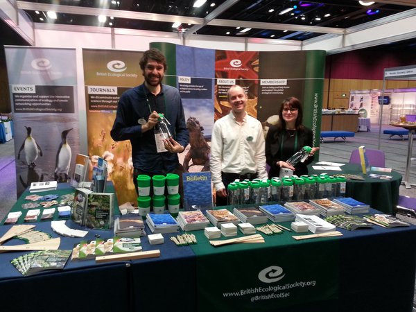
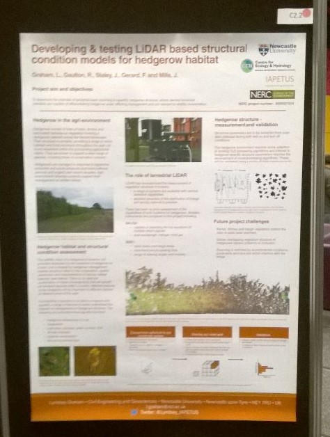
I attended the British Ecological Societies 2015 conference over 4 days in December in the beautiful city of Edinburgh complete with Christmas jumpers and a ceilidh. It was a great opportunity to present my work – using LiDAR to model and measure the effects of cutting and rejuvenation management on hedgerow structural condition as wildlife habitat; to over 1500 delegates and to engage with the more ecology focused side of my PhD.
(image credit: BES on twitter)
The conference saw talks and posters from across a range of ecological disciplines including using various remote sensing techniques to measure and monitor forests from the global to the local scale. This included Markus Eichhorn from The University of Nottingham who has invited me to present my work to his research group in the new year and was keen to hear of other relevant work going on in Newcastle CEG. I would encourage anyone in CEG whose work is based around forest ecology to consider attending next year’s meeting as their was a decent sized community of forest modelers in attendance.
Ensuring I could effectively communicate the potential of my work to such a broad range of scientists attending the conference was a big challenge and exciting opportunity. The conference was a great reminder for those working with emerging technologies or applying existing technologies to new challenges that communicating to the end users of your work is key. In my case this includes agricultural ecologists and policy makers with a range of interest and familiarity with remote sensing and LiDAR. I was asked everything from “What is LiDAR?” to questions about how LiDAR could add to a huge range of ecological monitoring challenges, stressing the real need for communication and sharing of ideas across disciplines. I also believe attending BES was a great way for my work to stand out and to really engage with what is novel about my project, as the only presenter (that I heard of) attending from a civil engineering discipline I was in a really unique position.
A number of us last week attended a workshop on visualisation, organised by Nick Holliman, professor of visualisation in the school of computing scince. After successfully having abstracts accepted David Fairbairn gave a presentation on ‘using geovisualisation in the decision theatre’ and Neil Harris presented his and Craig Robson’s work entitled ‘spatio-temporal network simulation and failure visualisation’ (as presented at GISRUK earlier in the year).
The aim of the workshop was to firstly share the work going on in the visualisation of data in research around different groups and departments across the university. This was achieved through a series of presentations giving an opportunity for people to present their work on visualisations as used in their research. This also gave the opportunity for them to raise questions about their work with regard to how to improve the visual outputs as well as pose thought provoking questions in the area of visualistion. This session provoked some productive discusions on the area of visualisation in gereneral in repsonce to the material presented.
The afternoon session focused on two questions; (1) what tools and methods are commonly used for visualisation in research and (2) what is required for the future of visualisations in research. Breakout groups were used to facilitate disscusions around these questions as well as full group discussions allowing key points to be discussed by the wider group.
The day proved useful in many ways by combining a range of people with varying thoughts and interests with regard to the visualisation of data. By the end of the day future meetings and collaborations were being discsused along with ideas on how to continue such meetings/workshops in the future.
As a research group a small number of us have been involved in the ITRC project over the past five years, namely Stuart Barr and Dave Alderson. Craig Robson joined the ITRC ranks in January, pausing his PhD work to help complete the final phase of the research required by autumn 2015. ITRC (Infrastructure Transitions Research Consortium) has been investigating the future of the UK’s national scale infrastructure with regards to how it must develop to meet ever changing demands and how climate change amoungst other factors will affect the resilience of those networks we rely on.
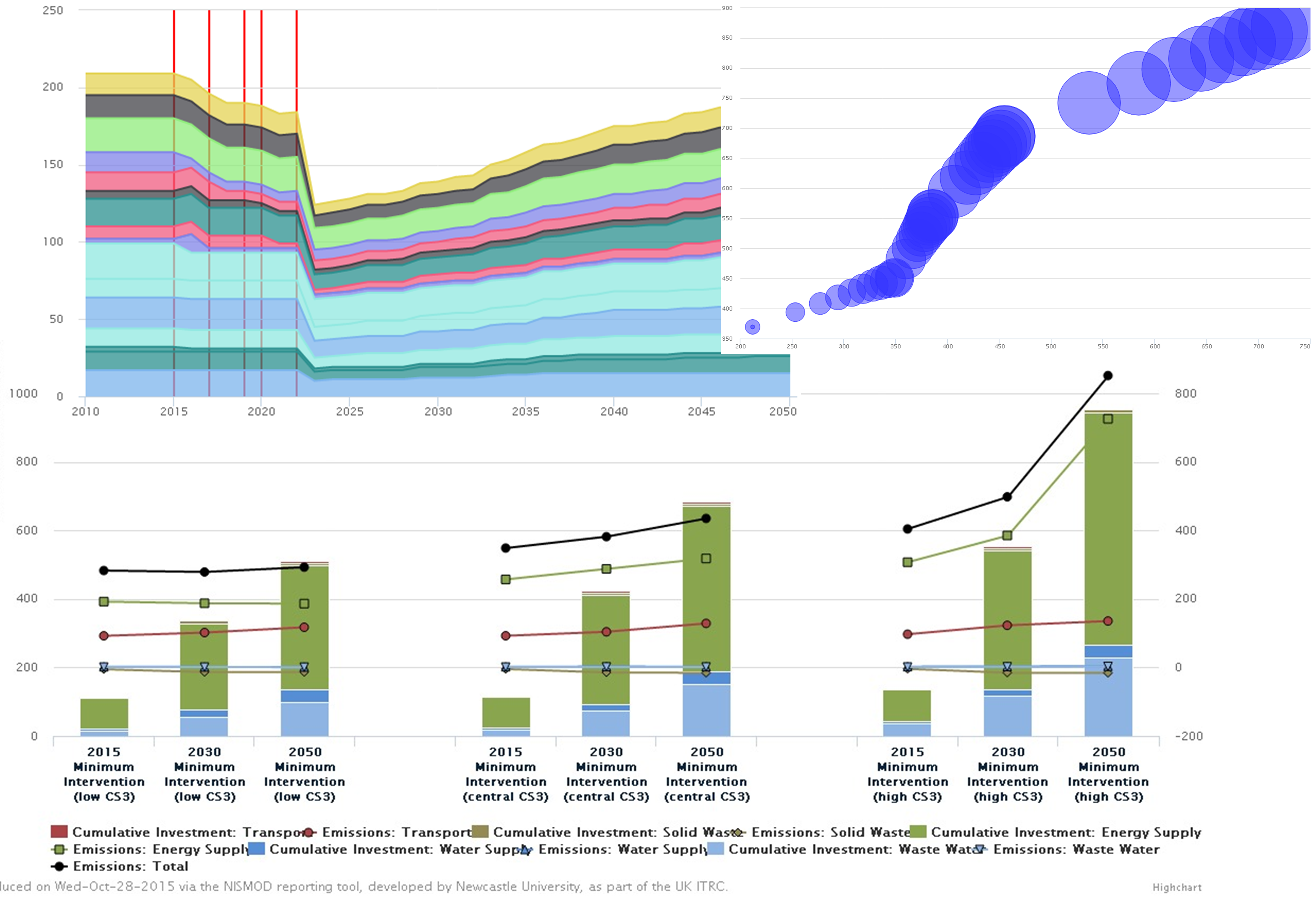
Our role in the project has centered around the development of the tools which would allow the five year project to be completed and included, but was not limited to, the development of the central database for all data for the project, and the support tools which would enable the analysis to be undertaken and results reported. It is on this later point where most of the past 6 months have been spent; developing a reporting tool for the presentation of the results from the long-term infrastructure planning aspect of the project.
The developed reporting tool allows users to view results from the each infrastructure sector (e.g. transport or waster supply), or view cross sector results, a set of similar metrics computed for each sector allowing for direct comparisons between them on there performance. For each sector a range of model outputs can be viewed from the level of emissions produced, to the running costs per year to the cumulative capital investment required. Results are shown not only at the regional level, but where possible at the sub-national level through the government office regions for example where the models output data at this granularity. This allows the tool to show data not just in charts, but also through maps, allowing new insights to be learned which may not be identified through non-spatial results. More detail on the tool, along with images and the like will be provided in a specific post at a later date, but for now a small selection of images below exemplify the tool.
With the end of the project looming near an event was organised at the ICE in London on the 15th October where the key results and impacts from the project could be disseminated to a wider audience with those key members behind the research all being present to answer questions and discuss their work. At the event we were available to demo the reporting tool and discuss the complexities behind the database for those interested, while a set of slides were used to give a overview of our work. More generally two videos (below) were produced giving an overview of the project and the one on the resilience of the UK’s national infrastructure.
Last week’s trip to the USA reminded me how cartography and GIS are central to American academic geography. I was invited to the Geography and Geology department of the University of Nebraska at Omaha (UNO) to give a research presentation on my work using LiDAR-sourced data to examine archaeological landscapes. It was good to join later in some of Mike Peterson’s classes: it was clear that his new book, ‘Mapping in the Cloud’, acts as an excellent basis for the syllabus of a course on web mapping. I also discussed the August pre-conference joint ICA Commissions (Education & Training/Maps & the Internet) workshop in Curitiba, Brazil: I chair the former, and Rex Cammack from UNO the latter, so we were able to firm up some of the co-organisation in person.
A couple of days later and 500 miles to the east, the AAG conference in Chicago beckoned and my Education & Training hat was retained, presenting a paper about accreditation in cartography, participating in a panel discussion about the role of cartography in GIS education, and invited to sit in with the luminaries on the UCGIS board crafting the extended ‘Body of Knowledge’ in GIS&T. There was also time to visit the Newberry Library in Chicago, where Volume 6 of the History of Cartography (published by the University of Chicago Press, and covering the 20th century) was launched. At 1,960 pages with 1200 illustrations, in two enormous volumes, it was astonishing to see the magnum opus in print. Luckily, contributors have been offered a .PDF copy, so I did not have to check in excess baggage at the airport …
Back in Vienna this week, I visited Gilbert Kotzbek at the Universitat Wien (which celebrates its 650th birthday this year). I have been discussing his PhD work on the use of GIS to examine football data with him for some time now, and he has created some excellent Python-scripted ArcGIS tools to input, filter, and analyse the staggering amount of spatial and attribute data captured during a game and interpreted after (1/25th second interval positional data for every player and ball, plus information about every event – tackle, throw-in, offside, corner etc). What’s missing in the data is the third dimension – it would be interesting to contrast the style of a long-ball team which keeps the ball in the air a lot, with a close-passing, tiki-taka side. I also had the chance to remind myself of teaching in a classroom, when I had a class with the 15 students of the International Masters MSc course in Cartography (who are all studying in Vienna this semester, having been at Dresden and Munich for previous semesters). This is a very international bunch from Egypt, China, Canada etc and closer to home from close-by Slovakia. The topic was VGI, so I was able to convey some of the thoughts which came out of Maythm Al-Bakri’s PhD study from a couple of years ago, and outline what Kaizer and Mustafa are doing in Newcastle now.
A group of 6 staff and PhD students attended the annual UK GIS conference (GISRUK) being hosted by Leeds University. With all but one presenting (though now GISRUK regular Phil James was named on three of the six presentations), the groups diverse and interdisciplinary range of work which related to GIS was well covered.
Congratulations must be given to Neil Harris and Craig Robson who won best paper for their paper entitled “Real time coupled network failure modelling and visualisation”. No doubt this was (at least in part anyway) down to a live demonstration by Neil during the presentation of the developed software/framework which worked (or so it appeared to those less who hadn’t seen it before!). See below for a link to the abstract and presentation.
It was also good to see a number of alumni who have continued to work in the field of GIS upon departing our department after three years of study.
Finally a thanks to organizing committee for putting together a great conference and for the bursary awarded to Craig.
The official conference proceedings can be found here.
Links to the six presentations (and abstracts) are below:
“Real time coupled network failure modelling and visualisation”, Neil Harris, Craig Robson, Stuart Barr and Phil James (Winning paper).
“Assessing the need for infrastructure adaptation by simulating impacts of extreme weather events on urban transport infrastructure”, Alistair Ford, Maria Pregnolato, Katie Jenkins, Stuart Barr, and Richard Dawson.
“A geospatial relational database schema for interdependent network analysis and modelling”, David Alderson, Stuart Barr, Tomas Holderness, Craig Robson, Alistair Ford and Ruth Kennedy-Walker.
It has been a good start to my two month sabbatical in Vienna. Georg Gartner and his team at the Technical University (TU) Wien Cartography department have been most welcoming, and my apartment (rented on the viewing of web-site photos alone) is gemutlich. It is great to be staying in one of my favourite cities.
I remember watching the 2006 World Cup final in a bar in Vienna full of excited Italians. By contrast, the Liverpool-Newcastle game was dull fare earlier this week: Flanagan’s was still smoky (I’d forgotten what watching a game in a bar where smoking is still allowed is like), but the capitulation of the Toon was no excitement for the (extremely small number of) black and whites. From the ridiculous to the sublime, the walk back home took me past the final aria of that night’s Opera performance, being beamed live from inside the Vienna Opera House to a sizeable crowd outside.
Included in that crowd I spotted Prof Ana-Maria Coutinho, opera buff and cartography academic from Rio de Janeiro (also vice director of the forthcoming International Cartographic Conference in Brazil in August). I caught up with her later in the week when she visited the department at the TU. We had a good chat about the joint ICA Commission on Education &Training/Commission on Maps & the Internet workshop which I am co-organising in Curitiba, before the main event in Rio.
I have been able to put the finishing touches to my presentations for next week in the US, and also finalised some proposals in liaison with the Newcastle archaeologists. And the texts for the Rio proceedings are due this month – my solo one already in, the paper by Kaizer, Phil and myself just about ready to go.
From Monday 30th March till Wednesday 1st April, the department hosted the annual Remote Sensing and Photogrammetric Society (RSPSoc) Wavelength Conference. Since it’s rebranding from the student conference, which was last hosted in Newcastle nine years ago, young professionals are now also welcome to present their research and latest developments in all aspects of remote sensing and photogrammetry. The conference was organised by third year PhD student, Andrew McClune, whose research is focussing on the automatic reconstruction of 3D building models from aerial photography.
The conference was well attended by approximately 40 delegates, mainly from UK institutes but with some travelling from as far as Nigeria and Turkey especially for the conference. A wide range of research topics were presented. The opening session was dedicated to the research of dust & gas detection from satellite platforms, before second year PhD student Magdalena Smigaj, presented her work entitled ‘’Remote sensing for UK forest health monitoring” in the first of the two vegetation sessions. The final session of the first day was a keynote session given by the International Society of Photogrammetry and Remote Sensing (ISPRS) Council members, who were in the area for an ISPRS Council meeting. Chen Jun opened with an introduction to the society before Christian Heipke, Leibniz Universität Hannover, and Marguerite Madden, University of Georgia, discussed their individual research topics “New approaches for automatic classification or aerial and satellite images” and “Geospatial Information Supporting Animal Movement and Habitat Studies”, respectively. The final day was closed with a meal at Blackfriars Restaurant, where ISPRS Council members and delegates continued to network and discuss research.
The conference prides itself on offering a strong scientific and social programme, with Tuesday morning being designated to the first batch of social activities. Whilst a small group went to battle it out over the annual game of laser quest, a local tour guide led the rest of the delegates around the many scenic delights that Newcastle has to offer. Although the weather did not hold up with a heavy downpour encountered mid-tour, the tour gave an insight into the history development of the city. The tour started along the Quayside visiting the many bridges along the river before working their way back to the University via the castle, Grainger market and Grey’s Monument.
Presentations resumed after lunch with the urban management topic which saw presenters from GetMapping UK present their street level imagery dataset and the online GIS platform for local parish councils, as well as the use of historical imagery for assessing planned urbanization. The second oral session of the day saw the second vegetation session of the conference and included the winner of Best Oral Presentation from Emily Norton, from Bournemouth University for her research entitled “Multi-Temporal remote sensing of mass graves in temperate environments”. She was proudly presented with a remote sensing book, kindly donated from sponsors Taylor & Francis.
A wide range of poster were presented towards the end of the second day with second year PhD Elias Berra discussing “Forest phenology monitoring by unmanned aerial vehicle” and first years Ben Grayson and Fikiri Mhenga presenting their proposed PhDs researching “Digital photogrammetric techniques in aid of UAV trajectory determination” and “Using remotely sensed products for improved hydrological models in high mountain hydrological regimes.” The final session of the second day was a sponsor session, where representative from Sterling Geo presented the latest developments of the ERDAS software suite whilst promoting the CHEST agreement, which entitles universities to purchased licences for the software at a heavily reduced price.
The second day finished with a meal on the Quayside before the second social event of the conference which saw delegates go bowling. For some it was their first time and they either took to bowling like a duck to water or were experiencing some beginners luck.
The final day was opened with a session dedicated to disaster management and prevention, which saw Maria Peppa and Polpreecha Chidburee, both second year Newcastle PhDs presented their individual PhD research topics entitled “Development of a UAV-based landslide monitoring system” and “Development of a low-cost, real-time photogrammetric monitoring system for landslide hazard analysis”. This was followed by a session of data integration before the conference was closed with a keynote address from David Holland, Ordnance Survey, presenting research on the creation of 3D datasets, a topic which he has been supervising Andrew on as part of his PhD.
A big thank you to the staff and PhD students that helped in the organisation and success of the conference, as well as Edward Malina from the Mullard Space Science Laboratory, part of University College London. Edward will now become the Wavelength Rep for RSPSoc and will now start to organise the next Wavelength conference in 2016.
We have already agreed to host some of Jacqui’s mini solar cell powered sensors and have already started to look at integrating Plenario (UCCD’s platform for displaying city metrics) as it is built on the same PostgreSQL/PostGIS/Python stack that we use for the Urban Observatory. Might be planning a trip to Chicago shortly!
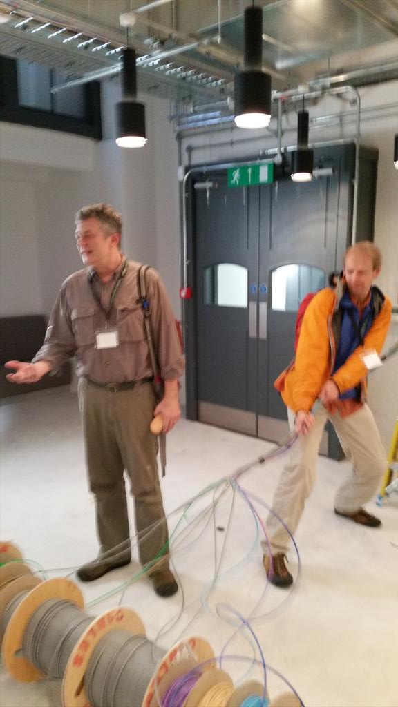
As part of my work on the CARIWIG project I have been lucky enough to visit the Caribbean on 4 separate occasions. These, despite the speculations from my colleagues, have been work packed trips with the majority of my time being spent in a windowless heavily air-conditioned room. My latest trip saw myself and Phil James from Geospatial engineering visit Barbados where we took part in the CARIWIG training event (which took place in various windowless rooms).
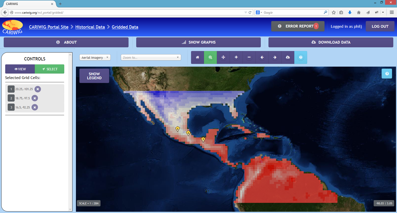
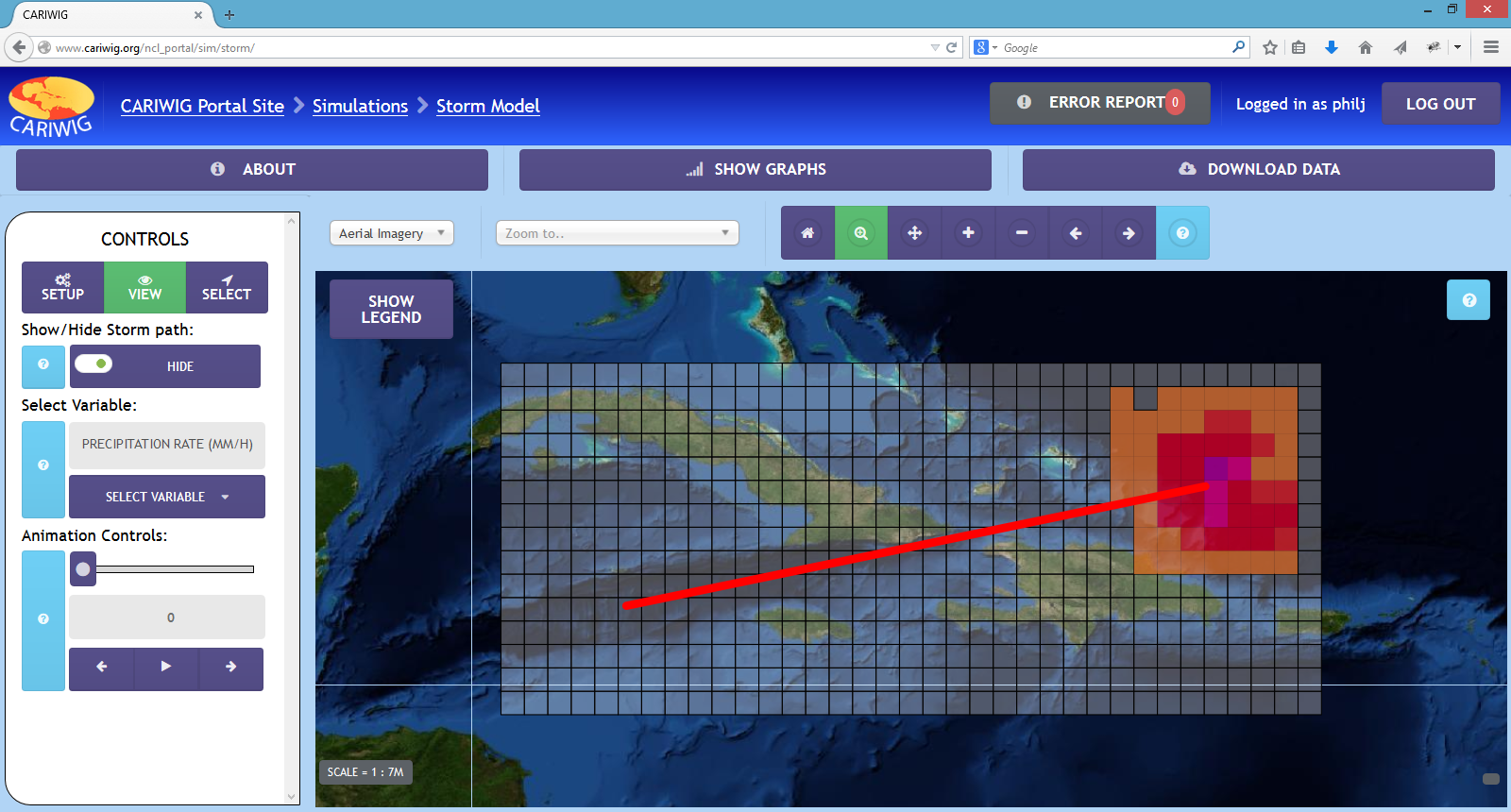
We were there presenting the work that we have done putting together the CARIWIG portal which is a portal designed to let the user visualise, graph and download both historical and simulated future cliamte datasets, as well as allowing the user to run a number of simulations across the region. For slightly more information see here
Gridded data viewer on the portal
Tropical storm model on the portal
Over the 3 days participants were introduced to the tools put together for the project and how they are run on the portal. They were then given time to use these tools to conduct their own mini case studies, with them then reporting their findings back to the group.
Overall the event was a great success with participants fully engaging with the tools put together and seeing their potential. And from a personal point of view, they liked the interface and found it intuitive. Plus there were 0 internal server errors, even when a entire room of people all ran the tropical storm model at the same time!
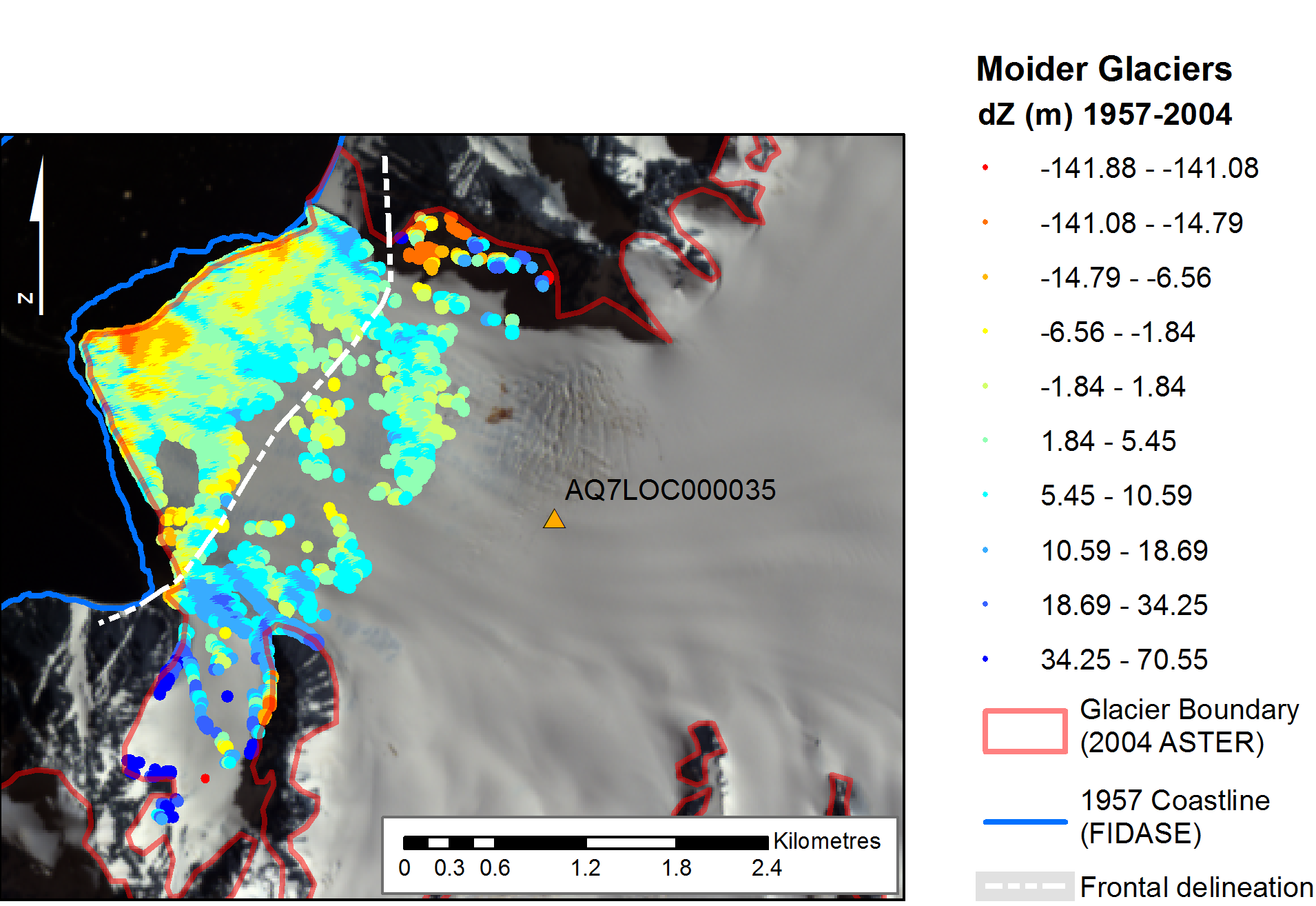
During my recent trip to the 2014 AGU Fall Meeting in San Francisco – see separate post (6th January 2015), myself and colleague Lucy Clarke (of British Antarctic Survey/University of Gloucestershire) were contacted by the BBC Science correspondent Jonathan Amos, who expressed interest in our Antarctic glaciers research. This subsequently led to the publication of an article on the BBC News website which reports on the project and some of work presented at AGU: http://www.bbc.co.uk/news/science-environment-30471542
This NERC-funded project, ‘The spatial and temporal distribution of 20th Century Antarctic Peninsula glacier mass change and its drivers (GCAP20C)’ is being undertaken in collaboration with colleagues at the British Antarctic Survey (BAS), with myself and Prof Jon Mills involved in the Newcastle component. The research is exploiting a unique archive of >30,000 aerial images of the Antarctic Peninsula which date back to the 1940s, enabling assessment of multi-decadal glacier change at around 50 benchmark glacier sites. This is providing insights into the spatial distribution of historical glacial mass balance changes across the Peninsula, which in turn will provide data for BAS ice sheet modelers to better calibrate simulations of future mass balance changes across the AP, and enhance understanding of changes to sea level, and other climate drivers.
The article was one of a number which stemmed from research presented at the AGU Fall Meeting, and even appeared as third lead article on the front page of the BBC website for a period! This reflects the fascinating nature of the research and the human story surrounding the determined, highly efficient and thoroughly professional team involved in the Falkland Islands and Dependencies Aerial Survey Expedition (FIDASE), led by Peter Mott of the former Hunting Aerosurveys. These survey professionals, and accompanying specialised team members, ventured forth into the unknowns of Antarctica over two field seasons between 1955-57. Not only did they undertake extensive and risky airborne missions to capture the photogrammetric imagery which provides much of the foundation for the GCAP20C project, but much of their focus was dedicated to field-based survey and triangulation in and around the South Shetland Islands and the adjacent west coast of the Peninsula. This involved painstaking optical observations by theodolite over extended distances and under extreme weather conditions, with teams often snowed in for days or even weeks at a time. It is this incredible and invaluable legacy from 60 years ago, which allows us to undertake the scientific analysis we do today as part of GCAP20C, and which will enable scientists to better understand the future response and impacts of this region in relation to climate change.