Pub statistics (1)

Anyone with any experience of working/visiting the Geomatics group will know that, just like in most other academic establishments, visits to the pub at the end of a hard week are just as important as anything else that happens during the working week. To this end, the Friday night pub call is now well and truly part of the culture of the group, and without some would be inclined to say they would feel lost without this. However, the visit to the pub could be argued to have fallen into the shadow of the call email itself, which depending on the sender, can tell a complex story which few understand and can only read with a face of utter bewilderment.

So, to cut to the chase, as an exploratory piece of ‘academic research’ we have compiled a comprehensive database, going back to the creation of the GWRS call email list, 2008, until the current day. Every pub call ever made over the past 7 years, that’s 397 Fridays, the pub and the person who made the call have been recorded (though some are blank due to public holidays and missing data). Further data has then been added including the weather to allow us to explore the call data in more detail, and attempt to understand any patterns which may or may not be present.

To start with, and to end this initial post here, below are some key initial statistics on the data we have collected.


Top 10 Pub Calls

Hotspur 50
Bacchus 48
Strawberry 42
Bodega 29
Lady Grey 20
Newcastle Arms 12
Town Wall 11
Bridge Hotel 10
LYH 9
Five Swans 9


Caller Stats

Caller Favourite Pub Number of Calls Number of Unique Pubs called
Martin Robertson Strawberry ( 33 ) 207 34
Laura Hanson Hotspur ( 11 ) 37 15
Ali Ford Bodega ( 10 ) 27 12
Matt Goode Five Swans ( 3 ) 15 11
Claire Walsh Cluny & Tilleys & Bacchus & Town Wall & Bodega & Strawberry & Trent House & Collingwood & Hotspur & Forth ( 1 ) 10 10
Richard Dawson Bacchus & Hotspur ( 2 ) 7 5
Peter Clarke Hotspur ( 2 ) 4 3
Tom Holderness Carriage & Bodega & Hotspur ( 1 ) 3 3
Ian Thomas Hotspur ( 2 ) 3 2


Top 10 Warmest Pubs

Average Temperature recorded in Newcastle at 5pm (c) Pub Number of Calls
16.5 Free Trade 4
14.5 Centurion 2
14 Northern Stage 3
13.5 Tilleys 4
13.4444444444 Five Swans 9
13.2 Pleased To Meet You 5
13.2 Bridge Hotel 10
12.6666666667 Bar Loco 6
12.5 City Tavern 4
12.0344827586 Bodega 29


Mean Weighted cntre of pub clals
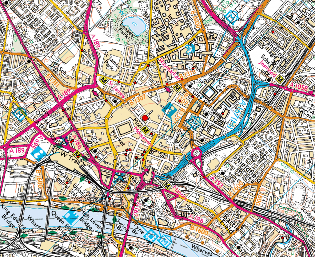
mean_cntre


Craig and Neil.

Summer school in Obergurgl


glaciers
glaciers
Geodetic ride
Geodetic ride

An amazing summer school took place last week in Obergurgl, Austria (http://www.uibk.ac.at/geographie/summerschool/). The focus was to investigate the various close range photogrammetry remote sensing techniques for alpine terrain research. Such an international environment made the atmosphere very interesting. I met other researchers from Austria, Germany, Italy, Poland and even Equador!!! Professors in remote sensing and photogrammetry from Germany and Italy insipred us with their talks.

The days were very busy with data collection in the alps and data processing, however the fieldwork gave us the opportunity to explore the beautiful mountains and refresh our minds. The best part of course was the social events with tasty austrian beers. The weather was incredibly warm, even the locals became crazy in such a warm environment; I couldn’t believe that Austrian drivers use the horn, this is a Greek habit!

The local newspaper reported the event on their website: http://www.tt.com/panorama/katastrophe/10251350-91/katastrophen-besser-lesen-lernen.csp

The organiser Dr. Martin Rutzinger successfully managed to create a great event and make everybody happy.
The 2nd attached picture shows how engineering is combined with nature. 🙂

Maria Valasia Peppa

Geospatial in Budapest

The central location of Vienna has allowed me to engage with some more people in the past few weeks. I and the other two members of the International Cartographic Association Statutes Committee, Ferjan Ormeling (Netherlands) and Bengt Rystedt (Sweden) met here a couple of weeks ago to discuss proposals for the ICA General Assembly in August. We were joined by my host here, ICA President Georg Gartner, and the Secretary-General Laszlo Zentai from nearby Budapest. Ferjan, Bengt and myself also form half of the Working Group on International Map Year (http://mapyear.org) and were able to make some further plans for this UN endorsed event. My ICA work in helping organise our Commission workshop in Curitiba in August continues from afar.

I spent a couple of days in Budapest this week – giving a seminar on VGI at the Eotvos Lorand University Department of Cartography & Geoinformation (a lively group of half a dozen staff and plenty students). It was good to meet again with Laszlo’s colleagues with wide ranging interests (Matyas Gede is currently exploring cave surveying and 3D visualisation, along with citizen mapping of tourist activity; Zsolt Torok is a historian of cartography, but also researches eye tracking; Andrea Podor, from a nearby university, examines environmental GIS and educational issues).

Back in Vienna I have been meeting with colleagues in my extensive host department, Geodesy and Geoinformation which has 7 research groups (https://geo.tuwien.ac.at/research-groups/). Gerhard Navratil in Geoinformation has interesting views on the topic of VGI and cadastral systems, which I am continuing to engage with Kaizer and Mustafa back in Newcastle. And Gottfried Mandelburger, familiar to Newcastle geomaticians having spent some time with us, has discussed further the archaeological work I have been interested in doing with LiDAR.

I’ve been doing some ‘map use studies’ by finding orienteering events to participate in whilst here – and it’s great that some wonderful terrain is available so close to Vienna and accessible by public transport. I even had a run in the suburbs of Budapest in torrential rain one hour after my seminar finished: a bit beyond the call of duty, but good training for a main event – the academic orienteering championships at the Danube Park next week (yes, there are enough university staff and students in Vienna to have a formal closed championship).

David Fairbairn

Geospatial in the USA

Last week’s trip to the USA reminded me how cartography and GIS are central to American academic geography. I was invited to the Geography and Geology department of the University of Nebraska at Omaha (UNO) to give a research presentation on my work using LiDAR-sourced data to examine archaeological landscapes. It was good to join later in some of Mike Peterson’s classes: it was clear that his new book, ‘Mapping in the Cloud’, acts as an excellent basis for the syllabus of a course on web mapping. I also discussed the August pre-conference joint ICA Commissions (Education & Training/Maps & the Internet) workshop in Curitiba, Brazil: I chair the former, and Rex Cammack from UNO the latter, so we were able to firm up some of the co-organisation in person.

A couple of days later and 500 miles to the east, the AAG conference in Chicago beckoned and my Education & Training hat was retained, presenting a paper about accreditation in cartography, participating in a panel discussion about the role of cartography in GIS education, and invited to sit in with the luminaries on the UCGIS board crafting the extended ‘Body of Knowledge’ in GIS&T. There was also time to visit the Newberry Library in Chicago, where Volume 6 of the History of Cartography (published by the University of Chicago Press, and covering the 20th century) was launched. At 1,960 pages with 1200 illustrations, in two enormous volumes, it was astonishing to see the magnum opus in print. Luckily, contributors have been offered a .PDF copy, so I did not have to check in excess baggage at the airport …

Back in Vienna this week, I visited Gilbert Kotzbek at the Universitat Wien (which celebrates its 650th birthday this year). I have been discussing his PhD work on the use of GIS to examine football data with him for some time now, and he has created some excellent Python-scripted ArcGIS tools to input, filter, and analyse the staggering amount of spatial and attribute data captured during a game and interpreted after (1/25th second interval positional data for every player and ball, plus information about every event – tackle, throw-in, offside, corner etc). What’s missing in the data is the third dimension – it would be interesting to contrast the style of a long-ball team which keeps the ball in the air a lot, with a close-passing, tiki-taka side. I also had the chance to remind myself of teaching in a classroom, when I had a class with the 15 students of the International Masters MSc course in Cartography (who are all studying in Vienna this semester, having been at Dresden and Munich for previous semesters). This is a very international bunch from Egypt, China, Canada etc and closer to home from close-by Slovakia. The topic was VGI, so I was able to convey some of the thoughts which came out of Maythm Al-Bakri’s PhD study from a couple of years ago, and outline what Kaizer and Mustafa are doing in Newcastle now.

bis zum nächsten Mal …

David Fairbairn

GISRUK 2015

A group of 6 staff and PhD students attended the annual UK GIS conference (GISRUK) being hosted by Leeds University. With all but one presenting (though now GISRUK regular Phil James was named on three of the six presentations), the groups diverse and interdisciplinary range of work which related to GIS was well covered.

Congratulations must be given to Neil Harris and Craig Robson who won best paper for their paper entitled “Real time coupled network failure modelling and visualisation”. No doubt this was (at least in part anyway) down to a live demonstration by Neil during the presentation of the developed software/framework which worked (or so it appeared to those less who hadn’t seen it before!). See below for a link to the abstract and presentation.

It was also good to see a number of alumni who have continued to work in the field of GIS upon departing our department after three years of study.

Finally a thanks to organizing committee for putting together a great conference and for the bursary awarded to Craig.

The official conference proceedings can be found here.

Links to the six presentations (and abstracts) are below:

  • “Real time coupled network failure modelling and visualisation”,  Neil Harris, Craig Robson, Stuart Barr and Phil James (Winning paper).
  • “Assessing the need for infrastructure adaptation by simulating impacts of extreme weather events on urban transport infrastructure”, Alistair Ford, Maria Pregnolato, Katie Jenkins, Stuart Barr, and Richard Dawson.
  • “Evolutionary Computing for Multi-Objective Spatial Optimisation”,  Daniel Caparros-Midwood, Stuart Barr and Richard Dawson.
  • “A geospatial relational database schema for interdependent network analysis and modelling”, David Alderson, Stuart Barr, Tomas Holderness, Craig Robson, Alistair Ford and Ruth Kennedy-Walker.
  • “Football fan locality- An analysis of football fans tweet locations”, Neil Harris and Phil James.
  • “Spatially modelling dependent infrastructure networks”, Craig Robson, Stuart Barr, Phil James and Alistair Ford

Geospatial in Vienna

It has been a good start to my two month sabbatical in Vienna.  Georg Gartner and his  team at the Technical University (TU) Wien Cartography department have been most welcoming, and my apartment (rented on the viewing of web-site photos alone) is gemutlich.  It is great to be staying in one of my favourite cities.

I remember watching the 2006 World Cup final in a bar in Vienna full of excited Italians.  By contrast, the Liverpool-Newcastle game was dull fare earlier this week: Flanagan’s was still smoky (I’d forgotten what watching a game in a bar where smoking is still allowed is like), but the capitulation of the Toon was no excitement for the (extremely small number of) black and whites.  From the ridiculous to the sublime, the walk back home took me past the final aria of that night’s Opera performance, being beamed live from inside the Vienna Opera House to a sizeable crowd outside.

Included in that crowd I spotted Prof Ana-Maria Coutinho, opera buff and cartography academic from Rio de Janeiro (also vice director of the forthcoming International Cartographic Conference in Brazil in August).  I caught up with her later in the week when she visited the department at the TU.  We had a good chat about the joint ICA Commission on Education &Training/Commission on Maps & the Internet workshop which I am co-organising in Curitiba, before the main event in Rio.

I have been able to put the finishing touches to my presentations for next week in the US, and also finalised some proposals in liaison with the Newcastle archaeologists.  And the texts for the Rio proceedings are due this month – my solo one already in, the paper by Kaizer, Phil and myself just about ready to go.

Auf wiedersehen …

Dr David Fairbairn

Quantifying hedgerow structure using terrestrial laser scanning

In January we were lucky enough to avoid the worst of the winter snow, wind and even rain on fieldwork based around the Centre for Ecology and Hydrology, Wallingford. This allowed us to take our first leaf-off hedgerow scans using a dual wavelength, full-waveform terrestrial laser scanner (SALCA – loaned to us from Salford University).

SACLA in action
SALCA in action

We visited the Defra hedgerow rejuvenation experiment at Newbottle Estate and scanned hedges managed under various rejuvenation techniques including coppice, circular saw, midlands style hedge laying and wildlife hedging. These first scans will form the basis of a methodology to better quantify hedgerow structure; developing processing algorithms capable of extracting structural variables including hedgerow height, width and gap fraction. Further scans will be undertaken using a hand held mobile scanner (ZEB1).

Hedgerow managed under coppice rejuvenation

The long term aim of the project is to both determine and further develop the potential of terrestrial laser scanning to quantify ecologically relevant elements of hedgerow structure. Being able to better quantify hedgerow structure and the impacts of management on structural condition is relevant to wildlife conservation within agri-ecosystems. Many hedgerows in the UK are either over managed or neglected, where cutting and rejuvenation techniques need to be used appropriately to achieve good structural condition over time. We anticipate a future role for terrestrial laser scanning in differentiating hedgerow under different management regimes, with differing structural condition and differing value for wildlife.

Lyndsey Graham

Geospatial Engineering in the News!

WhiskyGlacier
Whisky Glacier

During my recent trip to the 2014 AGU Fall Meeting in San Francisco – see separate post (6th January 2015), myself and colleague Lucy Clarke (of British Antarctic Survey/University of Gloucestershire) were contacted by the BBC Science correspondent Jonathan Amos, who expressed interest in our Antarctic glaciers research. This subsequently led to the publication of an article on the BBC News website which reports on the project and some of work presented at AGU: http://www.bbc.co.uk/news/science-environment-30471542

This NERC-funded project, ‘The spatial and temporal distribution of 20th Century Antarctic Peninsula glacier mass change and its drivers (GCAP20C)’ is being undertaken in collaboration with colleagues at the British Antarctic Survey (BAS), with myself and Prof Jon Mills involved in the Newcastle component. The research is exploiting a unique archive of >30,000 aerial images of the Antarctic Peninsula which date back to the 1940s, enabling assessment of multi-decadal glacier change at around 50 benchmark glacier sites. This is providing insights into the spatial distribution of historical glacial mass balance changes across the Peninsula, which in turn will provide data for BAS ice sheet modelers to better calibrate simulations of future mass balance changes across the AP, and enhance understanding of changes to sea level, and other climate drivers.

The article was one of a number which stemmed from research presented at the AGU Fall Meeting, and even appeared as third lead article on the front page of the BBC website for a period! This reflects the fascinating nature of the research and the human story surrounding the determined, highly efficient and thoroughly professional team involved in the Falkland Islands and Dependencies Aerial Survey Expedition (FIDASE), led by Peter Mott of the former Hunting Aerosurveys. These survey professionals, and accompanying specialised team members, ventured forth into the unknowns of Antarctica over two field seasons between 1955-57. Not only did they undertake extensive and risky airborne missions to capture the photogrammetric imagery which provides much of the foundation for the GCAP20C project, but much of their focus was dedicated to field-based survey and triangulation in and around the South Shetland Islands and the adjacent west coast of the Peninsula. This involved painstaking optical observations by theodolite over extended distances and under extreme weather conditions, with teams often snowed in for days or even weeks at a time. It is this incredible and invaluable legacy from 60 years ago, which allows us to undertake the scientific analysis we do today as part of GCAP20C, and which will enable scientists to better understand the future response and impacts of this region in relation to climate change.

Moider Glacier Change 1957-2004

AGU 2014 – San Francisco in December

GoldenGate

Immediately prior to Christmas, I was fortunate enough to attend the 2014 Fall Meeting of the American Geophysical Union (AGU) which ran from 15th – 19th December in San Francisco, California. The AGU Fall Meeting is a truly unique experience – the largest earth science gathering on the planet, with 25,000 delegates and a multitude of parallel sessions on an enormous range of topics, from deep ocean science to planetary geology; enormous, hangar-like poster halls with an ever-changing collage of scientific outputs, each one the culmination of months or years of hard analysis (in theory anyway!). Totally engaging, overwhelming, exhausting and inspiring. I was lucky enough to have been awarded an oral slot, and on the Thursday morning delivered a presentation on the results of our ongoing NERC-funded project, ‘The spatial and temporal distribution of 20th Century Antarctic Peninsula glacier mass change and its drivers’ – otherwise known as GCAP20C. Our colleague from the British Antarctic Survey/University of Gloucestershire, Lucy Clarke, was also attending and presented orally on her related work on GCAP20C. Both presentations were well received, and I presented to a sizeable audience in a session dedicated to glacier monitoring using remote sensing techniques. The Newcastle component of the research is quantifying multi-decadal mass changes to a benchmark set of 50 glaciers distributed across the Antarctic Peninsula (AP), exploiting a completely untapped resource of  >30,000 archival aerial images of the AP dating back to the 1940s. By comparing DEMs derived from this archival imagery to present-day ASTER DEMs we are able to quantify mass balance, and gain a clearer understanding of the spatial distribution of historical glacial change across the Peninsula. Alongside a more refined multi-temporal sub-sample of glaciers being analysed by Lucy and BAS, this information is crucially important to allow better calibration of models which predict mass changes into the future, and simulate how this would impact on processes such as sea level change.

Over the week I caught up with a few former Newcastle colleagues, including Liz Petrie (now a lecturer at Glasgow University, having moved in September 2014), and my good friend Shih-Yuan Lin (also known as Eric) who studied alongside me when we were undertaking our PhDs at Newcastle – pictured below. It was good to see both, and especially Eric, as our last face-to-face get together was a full 6 years ago now, at the ISPRS Congress in 2008.

Pauline and Eric at AGU 2014

During my only previous visit to the AGU FAll Meeting in 2006, I was unfortunate enough to encounter a week of incessant torrential rain. However, California has been experiencing drought conditions for quite some time, and prospects this year looked more encouraging (for me at least, if not for Californian farmers…). I was hoping for an escape from the cold, icy conditions which had gripped Newcastle in the early weeks of December. Some mild Californian sunshine would have been most welcome. My hopes were dashed however; the grey and misty, but initially dry skies which greeted my arrival at San Francisco International Airport were as good as it got – the rain quickly moved in as the conference got underway, and stayed put for the whole week. Nevertheless, San Francisco is a pretty special place to experience under any conditions, and with my imminent departure from Newcastle to a new job at the James Hutton Institute in Aberdeen, this final trip as an ambassador of Newcastle’s Geomatics group to AGU 2014 will stay with me for a long time to come.

Last UAV data collection of 2014 at Hollin Hill landslide

Landslide monitoring with UAV-based approach requires regular imagery acquisition at Hollin Hill British Geological Survey (BGS) observatory site, North Yorkshire. The attached UAV image reveals the progading lobe, intermediate scarps and other landslide features.

124000

The main purpose of this work is to detect the surface change and the landslide velocity field by combining surface matching algorithm and image correlation techniques with UAV-derived mutli-temporal DTMs.

So, last Monday (15/12/2014) was a successful day of the final UAV data collection for the year 2014 at Hollin Hill, UAV flying, terrestrial laser scanning and surveying … we are happy!

We are ready for more UAV flying next year.  Best wishes from the Newcastle UAV crew.

Newcastle UAV crew

Maria Valasia Peppa,   PhD student CEG