NERC Centre for Doctoral Training on Risk and Mitigation using Big Data award

School of Civil Engineering and Geosciences consortium awarded NERC Centre for Doctoral Training on Risk and Mitigation using Big Data.

The School of Civil Engineering, as part of a consortium between Cranfield, Newcastle, Cambridge and Birmingham Universities, have been awarded a NERC Centre for Doctoral Training on Risk and Mitigation using Big Data. The DREAM (Data, Risk And Environmental Analytical Methods) consortium comprises academics with expertise in environmental risk management and big data technologies and techniques. The consortium will train the next generation of risk specialists on the opportunities of ‘big data’ to improve our understanding of environmental risk mitigation options for industry, businesses, government and society. Over the coming years, DREAM will support 30 PhD students undertaking postgraduate research that seize the opportunities of ‘big data’ analytics to develop effective risk management strategies across the environmental sciences.

As part of the DREAM consortium, staff from the Water Resources and Geomatics research groups in the School of Civil Engineering and Geosciences will work with doctoral students on developing the next generation of big data and high performance computing approaches required to refine, scale and expand our ability to address key research questions being posed by industry and government in relation to risk assessment of geohazards, mitigation and management of extreme climate events, understanding and managing environmental risks faced by critical infrastructure systems and developing robust  long term sustainable protection plans of the Earths geobiophysical systems.

DREAM doctoral students at Newcastle will develop during the course of their research a comprehensive scientific skills set to address the challenges of risk mitigation in the environmental sciences. As our ability to monitor the Earth’s processes improves through a diverse range of different sources of data ranging from satellite observations through to ‘crowd sourcing’ it is imperative that modern environmental scientists are able to leverage maximum utility from the often diverse and large volumes of data available. DREAM students will receive training in how ‘Big Data Science’ can facilitate this, from the utilisation of different forms of high performance computing such as the cloud, utilising modern approaches to manage large heterogeneous environmental databases, through to the development of new computational approaches for analysis, modelling and synthesis of complex large volume environmental data-sets. In addition to developing skills in the use of ‘Big Data Science’ students will also receive project specific training in relation to environmental hazards, environmental impact and risk analysis methodologies, and training in risk mitigation and management.

The DREAM consortium is led in Newcastle University by Professor Chris Kilsby (Newcastle Director: chris.kilsby@newcastle.ac.uk) and Dr Stuart Barr (Academic Manager: stuart.barr@newcastle.ac.uk). Overall coordination of the consortium is being led by Cranfield University. Further details reading the award can be found at http://www.nerc.ac.uk/latest/news/nerc/bigdata/.

Meeting of ARCC Network Data and Information Management Group, University of Birmingham, January 7th 2015

January 7th saw the first face-to-face meeting of members of the ARCC Network Data and Information Management Group at the University of Birmingham, which GE-researcher David Alderson attended. Organised by Fiona Hewer, ARCC Network Data and Information Strategy Officer (Fiona.Hewer@ukcip.org.uk), the meeting offered the first opportunity for members to discuss data and information tracking within their respective projects. The “Liveable Cities” and “Designing Resilient Cities” (University of Birmingham) was represented by researchers and project managers, Joanne Leach and Amy Beierholm, with David Alderson discussing the ITRC project. Further to this, Ben Ryan, Senior Manager for Research Outcomes at EPSRC gave an overview of the EPSRC’s policy and framework for data, with members able to contribute from their own experiences or experiences of colleagues at their respective institutions of the recent submissions to the new “ResearchFish” tool.

Further information will become available once the minutes are completed, but in the mean time below are some interesting links that may prove useful:

Research Data Management Website @ Newcastle: http://research.ncl.ac.uk/rdm

EPSRC Policy Framework on Research Data: http://www.epsrc.ac.uk/about/standards/researchdata/

EPSRC Clarification and Guidance on Policy Framework for Research Data: http://www.epsrc.ac.uk/files/aboutus/standards/clarificationsofexpectationsresearchdatamanagement/

ARCC Network Website: http://www.arcc-network.org.uk

OpenARCC @ ARCC Network Website: http://www.arcc-network.org.uk/openarcc/

OpenARCC Data Website: https://openarcc.wordpress.com/


NERC Advanced Environmental Analysis using GIS

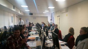
nerccourseimage This week we have over 20 NERC sponsored PhD students from across the country studying on a NERC sponsored Advanced Training Course. The students who come cover the whole gamut of NERC sponsored research are looking at how they can use GIS in their research. The course covers spatial analysis, spatial statistics, network analysis, terrain analysis, modelling tools and Python scripting. As well as working hard during the day the students are soaking up the famous Newcastle night life and making life long contacts. Hopefully, following the success of this course we will be able to provide future courses. Watch this space. This course is just one of the portfolio of GIS CPD and training courses that we offer see http://www.ncl.ac.uk/cegs.cpd/ for details.

Geospatial Engineering in the News!

WhiskyGlacier
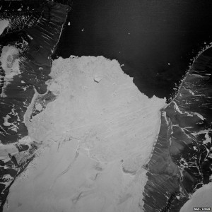
Whisky Glacier

During my recent trip to the 2014 AGU Fall Meeting in San Francisco – see separate post (6th January 2015), myself and colleague Lucy Clarke (of British Antarctic Survey/University of Gloucestershire) were contacted by the BBC Science correspondent Jonathan Amos, who expressed interest in our Antarctic glaciers research. This subsequently led to the publication of an article on the BBC News website which reports on the project and some of work presented at AGU: http://www.bbc.co.uk/news/science-environment-30471542

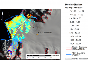
This NERC-funded project, ‘The spatial and temporal distribution of 20th Century Antarctic Peninsula glacier mass change and its drivers (GCAP20C)’ is being undertaken in collaboration with colleagues at the British Antarctic Survey (BAS), with myself and Prof Jon Mills involved in the Newcastle component. The research is exploiting a unique archive of >30,000 aerial images of the Antarctic Peninsula which date back to the 1940s, enabling assessment of multi-decadal glacier change at around 50 benchmark glacier sites. This is providing insights into the spatial distribution of historical glacial mass balance changes across the Peninsula, which in turn will provide data for BAS ice sheet modelers to better calibrate simulations of future mass balance changes across the AP, and enhance understanding of changes to sea level, and other climate drivers.

The article was one of a number which stemmed from research presented at the AGU Fall Meeting, and even appeared as third lead article on the front page of the BBC website for a period! This reflects the fascinating nature of the research and the human story surrounding the determined, highly efficient and thoroughly professional team involved in the Falkland Islands and Dependencies Aerial Survey Expedition (FIDASE), led by Peter Mott of the former Hunting Aerosurveys. These survey professionals, and accompanying specialised team members, ventured forth into the unknowns of Antarctica over two field seasons between 1955-57. Not only did they undertake extensive and risky airborne missions to capture the photogrammetric imagery which provides much of the foundation for the GCAP20C project, but much of their focus was dedicated to field-based survey and triangulation in and around the South Shetland Islands and the adjacent west coast of the Peninsula. This involved painstaking optical observations by theodolite over extended distances and under extreme weather conditions, with teams often snowed in for days or even weeks at a time. It is this incredible and invaluable legacy from 60 years ago, which allows us to undertake the scientific analysis we do today as part of GCAP20C, and which will enable scientists to better understand the future response and impacts of this region in relation to climate change.

Moider Glacier Change 1957-2004

AGU 2014 – San Francisco in December

GoldenGate

Immediately prior to Christmas, I was fortunate enough to attend the 2014 Fall Meeting of the American Geophysical Union (AGU) which ran from 15th – 19th December in San Francisco, California. The AGU Fall Meeting is a truly unique experience – the largest earth science gathering on the planet, with 25,000 delegates and a multitude of parallel sessions on an enormous range of topics, from deep ocean science to planetary geology; enormous, hangar-like poster halls with an ever-changing collage of scientific outputs, each one the culmination of months or years of hard analysis (in theory anyway!). Totally engaging, overwhelming, exhausting and inspiring. I was lucky enough to have been awarded an oral slot, and on the Thursday morning delivered a presentation on the results of our ongoing NERC-funded project, ‘The spatial and temporal distribution of 20th Century Antarctic Peninsula glacier mass change and its drivers’ – otherwise known as GCAP20C. Our colleague from the British Antarctic Survey/University of Gloucestershire, Lucy Clarke, was also attending and presented orally on her related work on GCAP20C. Both presentations were well received, and I presented to a sizeable audience in a session dedicated to glacier monitoring using remote sensing techniques. The Newcastle component of the research is quantifying multi-decadal mass changes to a benchmark set of 50 glaciers distributed across the Antarctic Peninsula (AP), exploiting a completely untapped resource of  >30,000 archival aerial images of the AP dating back to the 1940s. By comparing DEMs derived from this archival imagery to present-day ASTER DEMs we are able to quantify mass balance, and gain a clearer understanding of the spatial distribution of historical glacial change across the Peninsula. Alongside a more refined multi-temporal sub-sample of glaciers being analysed by Lucy and BAS, this information is crucially important to allow better calibration of models which predict mass changes into the future, and simulate how this would impact on processes such as sea level change.

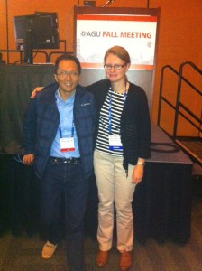
Over the week I caught up with a few former Newcastle colleagues, including Liz Petrie (now a lecturer at Glasgow University, having moved in September 2014), and my good friend Shih-Yuan Lin (also known as Eric) who studied alongside me when we were undertaking our PhDs at Newcastle – pictured below. It was good to see both, and especially Eric, as our last face-to-face get together was a full 6 years ago now, at the ISPRS Congress in 2008.

Pauline and Eric at AGU 2014

During my only previous visit to the AGU FAll Meeting in 2006, I was unfortunate enough to encounter a week of incessant torrential rain. However, California has been experiencing drought conditions for quite some time, and prospects this year looked more encouraging (for me at least, if not for Californian farmers…). I was hoping for an escape from the cold, icy conditions which had gripped Newcastle in the early weeks of December. Some mild Californian sunshine would have been most welcome. My hopes were dashed however; the grey and misty, but initially dry skies which greeted my arrival at San Francisco International Airport were as good as it got – the rain quickly moved in as the conference got underway, and stayed put for the whole week. Nevertheless, San Francisco is a pretty special place to experience under any conditions, and with my imminent departure from Newcastle to a new job at the James Hutton Institute in Aberdeen, this final trip as an ambassador of Newcastle’s Geomatics group to AGU 2014 will stay with me for a long time to come.

Last UAV data collection of 2014 at Hollin Hill landslide

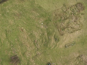
Landslide monitoring with UAV-based approach requires regular imagery acquisition at Hollin Hill British Geological Survey (BGS) observatory site, North Yorkshire. The attached UAV image reveals the progading lobe, intermediate scarps and other landslide features.

124000

The main purpose of this work is to detect the surface change and the landslide velocity field by combining surface matching algorithm and image correlation techniques with UAV-derived mutli-temporal DTMs.

So, last Monday (15/12/2014) was a successful day of the final UAV data collection for the year 2014 at Hollin Hill, UAV flying, terrestrial laser scanning and surveying … we are happy!

We are ready for more UAV flying next year.  Best wishes from the Newcastle UAV crew.

Newcastle UAV crew

Maria Valasia Peppa,   PhD student CEG


Geospatial in Grenada – Ivan 10

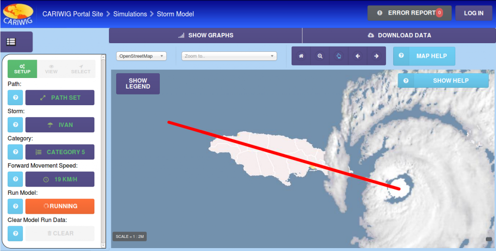
From the 1st – 3rd of December I visited a very sunny Grenada attending the 10th anniversary of Ivan symposium. This looked at the lessons learnt from the fallout of hurricane Ivan across the Caribbean region and how different sectors could help to prevent a future hurricane having a similar affect. I was there representing the CARIWIG project, along with Professor Michael Taylor and Jayaka Campbell from UWI, Jamaica. Michael Taylor brilliantly outlined the project and demonstrated elements of the portal site that I have been putting together over the past year. The presentation was very well received with myself and Jayaka Campbell being asked to demo the storm model element of the portal to a number of delegates.

The CARIWIG portal site is likely to go live following a workshop event in February so watch this space for more details.

storm6
CARIWIG Storm tool

I would like to thank the members of of CDEMA for putting on this event, the conference was well run and contained many interesting talks about hurricane Ivan, including a opening address from the Prime minister of Grenada, as well as plenty of Caribbean food as lunch times. Plus December in Grenada beats December in the north east of England

Whitley Bay eat your heart out

Neil – @neil_py_harris

Sankey diagram of cobalt life-cycle

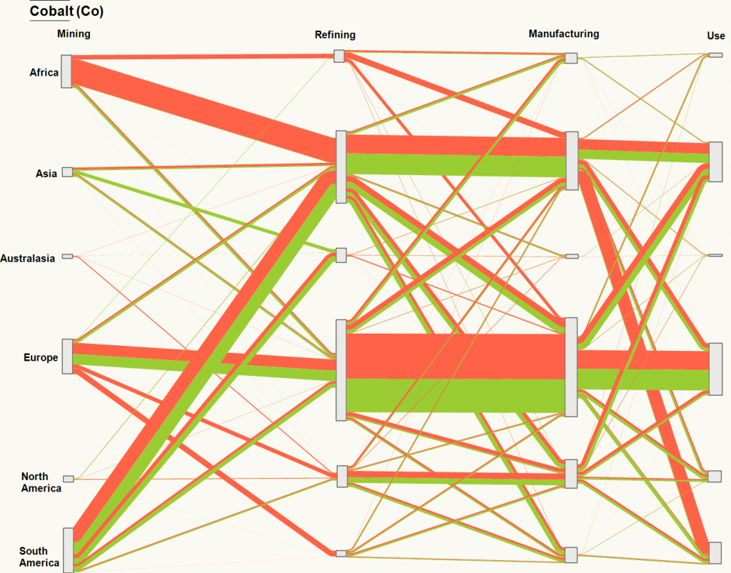
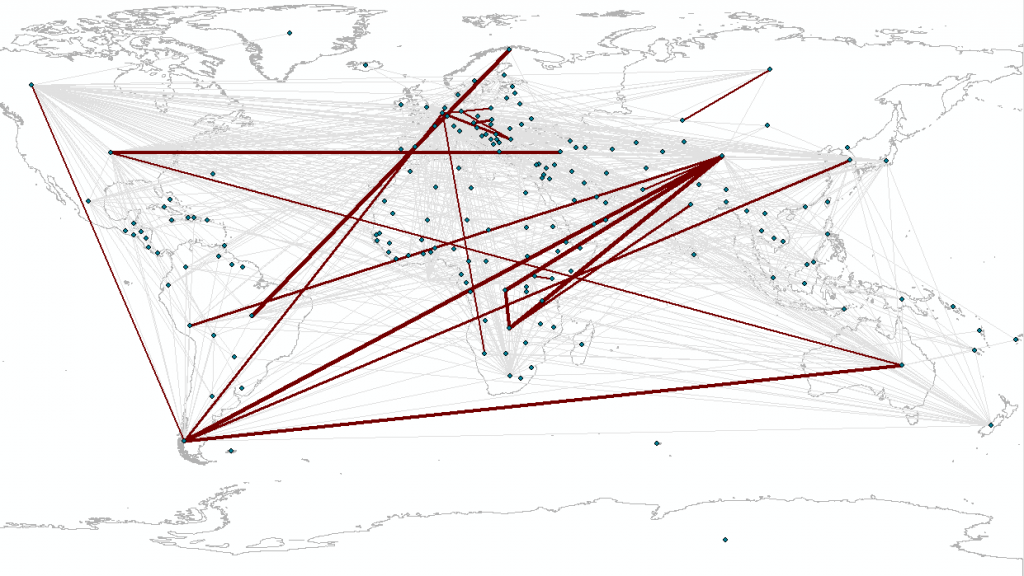
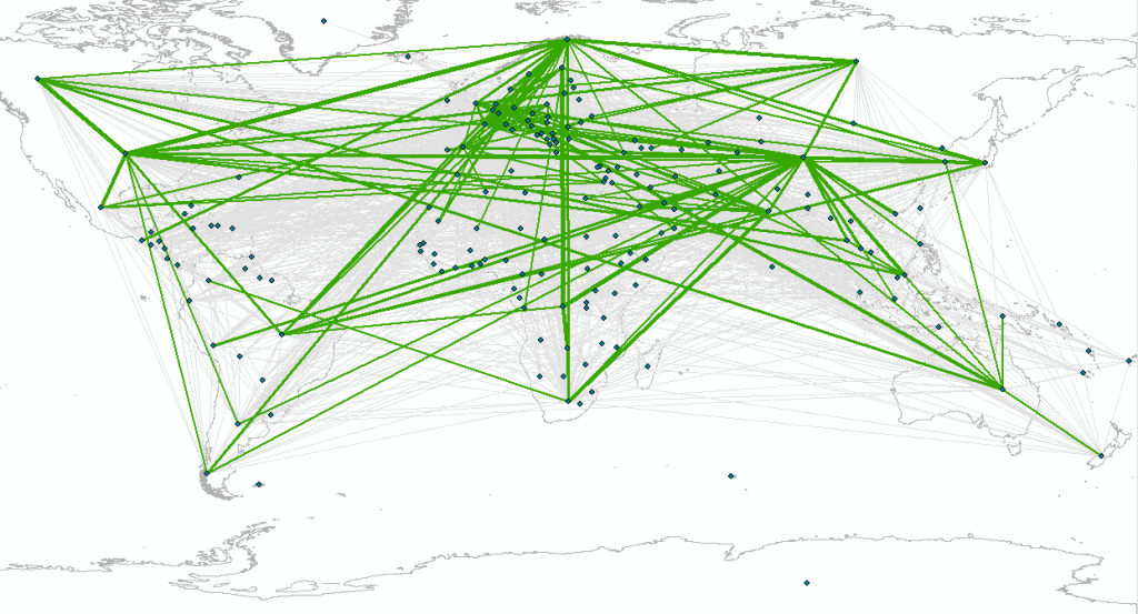
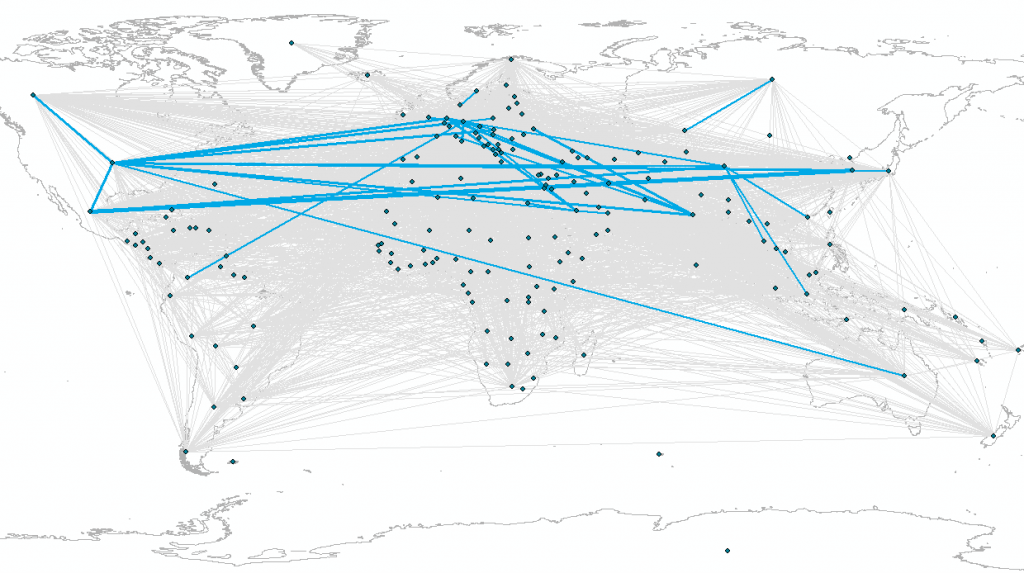
Working with colleagues Ali Ford, Oliver Heidrich, and David Manning on various papers and proposals, we have started to pull together a Sankey diagram of the reported tonnages of cobalt in 2012 through various processing stages within its life cycle. The orange and green colours denote the quantities of cobalt reported by the respective importing or exporting countries, but we have aggregated to the continent level. This information was extracted from the UN COMTRADE database and linked to eSankey! software via an intermediate Excel spreadsheet. The good thing about this approach is that by updating the spreadsheet with new values e.g. for different years etc, or for different elements/commodities/products, we can auto-generate (ish) the Sankey diagram.

Cobalt_2012_Sankey_Mining_Refining_Manufacturing_Use

Source: Cobalt, 2012, DESA/UNSD, United Nations COMTRADE Database

Going even further, Ali reproduced the data above at the country-level, across the same three stages i.e. Mining->Refining; Refining->Manufacturing; Manufacturing->Use, but using only the import flow data for now (matches orange flows above)

Comtrade_Cobalt_Full_Input_Imports


Source: Cobalt, 2012, DESA/UNSD, United Nations COMTRADE Database – Mining to Refining imports only

Comtrade_Cobalt_Full_Intermediate_Imports


Source: Cobalt, 2012, DESA/UNSD, United Nations COMTRADE Database – Refining to Manufacturing imports only

Comtrade_Cobalt_Full_Use_Imports


Source: Cobalt, 2012, DESA/UNSD, United Nations COMTRADE Database – Manufacturing to Use imports only


EuroSDR 3D SIG……. the first of many meetings to come

Last Thursday and Friday (27th – 28th November) saw the joint European Spatial Data Research (EuroSDR) and International Society of Photogrammetry and Remote Sensing (ISPRS) ‘Workshop for capturing national scale 3D models’. Hosted at Ordnance Survey, Southampton, the workshop brought national mapping agencies, industry vendors and research scientists together to discuss all things 3D  including the storage of 3D data (Hans Veihmann, Oracle) and making building models look more realistic with automatic texturing (Gerald Forkter, UVM Systems Gmbh).

Several presentations were given through the duration of the workshop, including those from the three Ordnance Survey funded PhD students focusing on 3D modelling. Firstly, Jon Slade, Cardiff University, presented methods of adding semantic and geometric information to a 3D model using imagery from repositories such as Flickr. I then presented my research on automatic 3D reconstruction from multi-ray photogrammetry, with the slides available here. Kelvin Wong, University College London, presented some preliminary results of an experiment to determine which parts of buildings people look at whilst navigating to determine what users may require from 3D models.

Examples of where national scale 3D models have been implemented were presented. Sander Oude Elberink, University of Twente, presented a case study of how part of his PhD research is being implemented by the Dutch Kadaster. Building footprints are extruded to a height calculated from lidar point clouds to produce a 3D national dataset. Height are also applied to roads, bridges and water bodies. Similar work is being undertaken by Ordnance Survey, presented by Isabel Sargent, by applying height attributes to OS MasterMap building footprints for the base of the building and various parts of the roof. This is currently available as an alpha release. Other research being undertaken includes automatic classification of roof structures using machine learning and clustering, as well as the research being undertaken by the PhD students listed above.

A series of breakaway groups were formed during the workshop to discuss matters such as the management of 3D data, what 3D editing tools need to be applicable, and the best approach to creating 3D models: whether this be developed from existing 2D datasets or to start data capture and production as a new process. Whilst no formal answers were concluded, these matters are to be further discussed and developed as part of the special interest group (SIG) and presented at the next workshop meeting, to be held in March 2015. One topic is to determine what are the potential economic benefits of national and regional 3D models by answering the following questions;

  • What is defined as a regional or national dataset? What is defined as 3D?
  • What added value does a national or regional 3D dataset have over local and project-based datasets?
  • What are the economic benefits of 3D data, if any, gained from this level of extended coverage?
  • What business opportunities can be realised through the application of 3D data at a national level?
  • Beyond technical challenges, what are the additional problems that NMAs face at this level of coverage?

This research is being fronted by Kelvin Wong, who requires participants to undertaken a short interview. If you would like to take part in this research please email kelvin.wong.11@ucl.ac.uk.

Thanks go to Rollo Home and Jantien Stoter for the hosting and organisation of the workshop. The points raised in this workshop led to many discussions and opinions, which hopefully may become closer to being solved by the next meeting in March 2015. Information on the SIG can be found at http://www.eurosdr.net/research/project/eurosdr-special-interest-group-3d-3d-sig

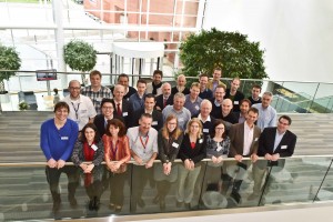
Photo of the delegates from the EuroSDR 3D workshop at Ordnance Survey, Southampton

Andrew McClune
3rd Year PhD Student

Autumn in the PhD office

To begin with, in September we welcomed three new PhD’ students to our group, Ben Grayson, Lyndsey Graham and Mustafa Hameed. The former, Ben, is used to the surroundings having completed our surveying and mapping science degree (BSc), graduating over the summer. Lyndsey and Mustafa join us from other institutions, adding to the diverse range of students currently amongst the cohort of PhD students. They will soon submit their proposals so look out here for updates on their research subjects.

Back to the more experienced PhD students, Daniel Caparros-Midwood (4th year) attended and presented at a conference in Taiwan on his work in finding the optimal spatial locations for developments given the changing climatic conditions. Also, this week Andrew McClune is attending and presenting in Southampton at an Ordnance Survey’s research event for their researchers, affiliated researchers (including PhD students) and invited guests.

Looking forward within the past month a number of PhD students, researchers and staff have submitted abstracts for the GISRUK (GIS Research UK) conference, being hosted by the University of Leeds in 2015. Being an annual dedicated GIS conference in the UK it usually attracts a good mix of presenters and attendees from a spectrum of backgrounds, with our group usually well represented at the conference. If interested, the conference is still open to submissions for presentations and posters.

Finally, Andrew McClune has been working hard over the past few months in arranging the annual RSPSOC (Remote Sensing and Photogrammetry Society) student and early career researchers conference, wavelength, which is to be hosted by our department in the spring, March 30th – April 1st. The abstract deadline for submissions is 9th January, and for those wishing to attend and/or experience Newcastle, recently voted the UK’s best city (which to be honest we already new!), details will be released closer to the event so keep an eye on this blog, the website@rspsoc_wlength  or @GeospatialNCL.