SHOCK Project Dissemination Event

SHOCK (NOT) HORROR is an EPSRC-funded project that, over the past two years, has been looking at how ‘shock’ events can provide opportunities for learning about and transformation of infrastructure systems.

On Friday 22 November (10am to 4pm) we will be holding our final project dissemination event at The Royal Society in London. The event will include an overview of the project process, methodologies and findings. Interactive sessions will draw upon a number of  activities and experiments that the project has conducted to prompt discussion around identifying barriers and enablers for change and innovation of infrastructure systems. A final open discussion on the value of this research and its outcomes, alongside other on-going research programmes will aid identification of future research priorities.

If you would like to register to attend please complete the following form:  http://forms.ncl.ac.uk/view.php?id=5061. Please feel free to circulate the attached project information flyer to others who may be interested in the event.

A more detailed programme will be available nearer the time of the event.

What an Asteroid Belter!

As part of the British Science Festival 2013 being hosted at Newcastle University, researchers, staff, lecturers and students were invited to contribute to a comic being developed and designed by local comic enthusiasts. The comic was officially targeting children between the ages of 8-13, with a view to promoting STEM subjects and science in general. The proposed content of the comic had, you guessed it, a distinctly scientific theme to it, with organisers interested in hearing from those staff members who could fit their work (or at least make it look like their work fits) in to one of the following themes:

  • Robots
  • Explosions and danger
  • Dinosaurs
  • Space, time and travel
  • Very big and very small things
  • Things we eat, and things that eat us
  • Codes, ciphers and hidden messages
  • Heroes and villains
  • Matters of life and death

Some of the work related to networks, connectivity and infrastructure that is currently being conducted within the context of the Infrastructure Transitions Research Consortium (ITRC – www.itrc.org.uk) and also within the School of Civil Engineering and Geosciences, seemed like something that kids could be interested in, and the idea of presenting this type of work within a comic context offered an alternative and novel mechanism for communicating our research. Once an expression of interest in contributing to the comic had been lodged, it was simply a case of meeting an artist and writer assigned by the organising committee, and beginning to think about what a comic to represent networks, connectivity and infrastructure should look like! In fact, largely due to the expertise and imagination of the artist I had been assigned (Terry Wiley), the ideas began to come together, and rather than stick to the traditional panel-based approach we decided on more of a spider diagram affair to communicate how different bits of infrastructure are connected together. However I still wish we had managed to get our idea of slightly transparent paper with networks hidden until the page was held up to the light, to fly to communicate the idea of hidden or non-obvious connections! Oh well, maybe next time. For all those interested, the comic, entitled “Asteroid Belter”,  in hard copy format was distributed at the British Science Festival 2013 (7th-12th September), but more information about it can be found here.

Post by David Alderson

Students flood to measure the BlueLine

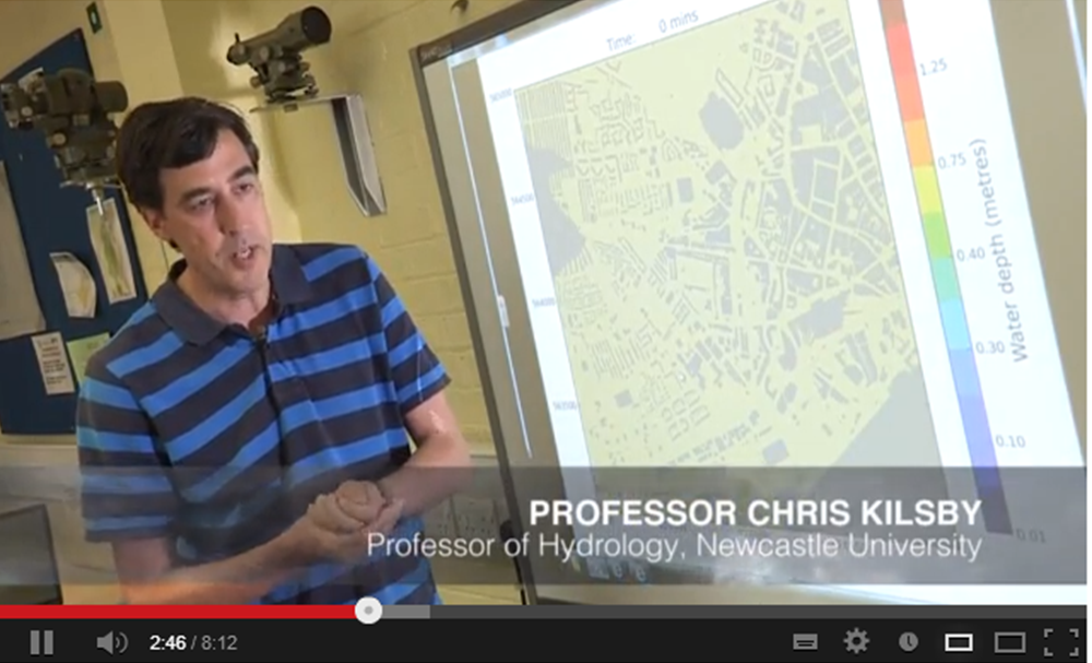
The hosting of the British Science Festival 2013 by Newcastle University gave staff and researchers of the School of Civil Engineering and Geosciences a chance to “show off”  some of their research to the general public, whilst also gave the opportunity to generate interest in science, technology, engineering and maths (STEM) subjects via hands-on activities delivered to school children from the North East. One such activity, named “BlueLine”, organised and delivered by Dr Geoff Parkin (Senior Lecturer in Hydrology), Professor Hayley Fowler (Professor of Climate Change Impacts), Dr Vedrana Kutija (Lecturer in Computational Hydraulics), Dr Claire Walsh (Researcher in Water Resources), Mr Vassilis Glenis (Researcher in Water Resources), Mr Philip James (Senior Lecturer in GIS), and Mr David Alderson (Researcher in GeoInformatics), focussed on explaining the complex nature of flooding and extreme flooding to separate groups of secondary school children from local schools in the North East. The schools represented are listed below:

–          Shotton Hall Academy, Peterlee

–          Berwick Academy, Berwick

–          Ponteland High School, Ponteland

–          Thomas Hepburn School, Felling

The sessions began with Dr Parkin delivering a brief summary of some of the causes of flooding and extreme flooding, citing many references that relate to flood events experienced in recent years within the UK, including those that occurred in Cumbria in 2005, Tyne and Wear in 2008 and 2012, and many others. However that was just the standard “in-class” part of the activity, and although the seminar generated interest from the students in such topics as the water cycle, climate change, global warming, and the impacts of flooding, the “really” interesting part came when the children were let loose outside on the University campus, to take part in a crowd-sourcing exercise.

Crowd-sourcing in it’s most simple terms involves members of the public contributing data, information, comments, stories, pictures etc, which are then subsequently used within some form of analysis. Within the School of Civil Engineering and Geosciences, there has been a concerted effort since the flooding in a local market town, Morpeth, in 2008, by water and geomatics researchers and lecturers alike to collect as much crowd-sourced based information about flooding and flood events that occur within the region. The contributions from the general public about the locations and timings of floods, alongside photography giving a reasonable indication of flood depths, levels and wrack lines, can be used to validate computer simulations of flood models, developed within the School. Some of the results of these crowd-sourcing endeavours can be found here.

So the purpose of crowd-sourcing in the context of flooding was explained to the students in attendance at the Blueline event, and how it can be used to help better understand how a flood propagates through different environments. Since the floods in 2008 and 2012, Philip James has developed an Android-compatible “app” that helps to facilitate this process, by allowing a user to use the location technologies within an Android device (tablet, smart phone etc) to locate themselves, and then subsequently use the camera to take a picture. The great thing about the app is that this data can then be sent to a server and published immediately onto a website, giving a near-real time record and subsequent archive of a flood event. As stated, this type of data is invaluable to understanding how a flood arises and then subsides. For more information about the app and the technologies employed to deliver this solution, have a look here.

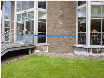
So the school children were escorted outside where a “pretend” flood had been erected around Newcastle University campus (effectively just a line of blue tape indicating a flood level based on a particular amount of rainfall), and asked to use the app and a tape measure to record information about the depth of this “flood”. This seemed to go down a storm (sorry) as it offered them a chance to do all the things that children seemingly would rather be doing i.e. being outside and playing with technology! Each pairing were asked to try to record at least one reading at each point where we stopped around campus. Further to this a series of QR codes had been erected along the blue line that the students were able to scan, subsequently directing them to a site of historical photography of the flooding that occurred on campus in 2012, as well as some “constructed” imagery of the imaginary flood that they were measuring. For more information on this site and the photos, please follow this link.

Post by David Alderson

   
The “BlueLine” around campus, denoting an imaginary flood level The reconstructed flood represented by the “BlueLine”

@BritishSciFest CESER researchers at the British Science Festival

This week the British Science Festival is being held in Newcastle. CESER researchers are involved in a number of activities:

  • David Alderson and Hayley Fowler have both contributed to the Newcastle Science Comic. David worked with Terry Wiley to produce ‘Everything’s Connected’ and Hayley with Adam Murphy on the ‘Climate Change and Extreme Weather’ comic strips. Asteroid Belter – The Newcastle Science Comic will be launched at Newcastle City Library on Saturday 7th September, 9.30am-5.30pm.
  • In recent months, Claire Walsh has been working with artist Adam Chodzko who has produced a podcast about climate change and flooding in the region. Adam was commissioned by Invisible Dust and Great North Run Culture to produce a piece which will be launched on Saturday 7th September at the Tyneside cinema. Adam’s podcast, ‘Rising’ can also be heard here.
  • Following on from the launch of ‘Rising’, arranged by Invisible Dust, Claire Walsh and PhD student Liz Lewis will be working alongside four local artists on Sunday 8th September in the grounds of St Thomas’ church near the Haymarket. From 12-6pm, members of the public can take part in art and craft activities to depict and visualise climate change issues and impacts.
  • On Wednesday 11th September at 2pm, Professor Hayley Fowler will deliver the Joseph Lister Award Lecture, ‘What’s happening to our weather’. The event  is being held at the Northern Stage. This lecture will discuss what causes different types of extreme flood events and whether this is increasing based on the latest evidence.
  • Throughout the festival on campus look out for our ‘blue line’. The ‘Blue Line’ project was set up to illustrate how extreme weather conditions can affect urban areas such as the Newcastle University campus, and how we can use computer models and data to help design sustainable solutions to reduce flood risk. The Blue Line illustrates possible flood levels from an extreme rainstorm, and the arrows show the main flow directions.An activity using the blue line is taking place during the young person’s programme running from Monday to Thursday. Find out more here or contact Geoff Parkin.

Luke Smith: best paper by a young author at the International Conference on Flood Resilience #ICFR

Luke Smith won best paper by a young author at the International Conference on Flood Resilience held at the University of Exeter this week. Luke’s paper, ‘A flexible hydrodynamic modelling framework for GPUs and CPUs: application to the Carlisle 2005 floods’ built upon his MSc dissertation project. Luke has just completed the first year of his PhD, ‘High-resolution hydraulic modelling of flood attenuation features in catchments’,co-supervised by Dr Qiuhua Liang and Dr Paul Quinn. Earlier this week Luke also had his first international journal paper accepted by Computers and Fluids. A great week, well done Luke.

Advertising for a new “Research Impact computing officer” #jobs #newcastle #python #postgis #webdeveloper

Find the full job description and apply at: http://tinyurl.com/okwe545

Based at Newcastle University in the School of Civil Engineering & Geosciences, you will use your advanced computer programming and web skills to develop new and innovative approaches to making cutting-edge Civil Engineering, Geomatics and Geoscience research accessible to non-academic audiences and supporting the School’s research communication strategy more generally.

You may come from any technical background, but will have extensive knowledge of programming (ideally, this would include Python, Django, PostGIS, JQuery) and web development. You will also have experience of interface development and visualisation of data. In addition to having a strong technical background, you will have good interpersonal skills and the ability to adapt your skills to a range of applications. You will be ambitious and have an interest in communicating research findings to non-academics.

Duration: 2 years in the first instance, extension subject to success of activities.

For informal inquiries please contact richard.dawson@ncl.ac.uk or ian.head@ncl.ac.uk

Find the full job description and apply at: http://tinyurl.com/okwe545

#Urban #climate preparedness in the UK

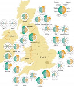
A new map reveals how prepared UK cities are for climate change.

The ability of cities to combat the cause of climate change and to adapt to future weather patterns depends on where we live in the UK, new research suggests.
Scientists at Newcastle University have revealed a “postcode lottery of preparedness” across the country based on what each city is doing to not only reduce greenhouse emissions but also adapt to future climate change and extremes of weather such as flooding and drought.

Devising a new way of ranking cities – the ‘Urban Climate Change Preparedness Scores’ – the team scored 30 cities based on four levels of readiness: Assessment, Planning, Action and Monitoring.  Publishing their results today in the academic journal Climatic Change, they reveal huge variation across the UK with London and Leicester gaining the highest scores both for adaptation and mitigation and Wrexham and Derry the lowest.

Newcastle University’s Dr Oliver Heidrich who led the research said it highlighted at a glance the “state of readiness” across the country and how prepared we are for the future.  “Of the 30 cities we assessed, all of them acknowledged that climate change was a threat and all except two had a strategy or policy in place to reduce emissions and also adapt to cope better with future weather patterns, in particular flooding,” explains Dr Heidrich, a senior researcher in the Centre for Earth Systems Engineering & Research (CESER).

“But a plan is only any good if you implement it and then assess it to see how effective it has been, this requires a long term investment in the strategies. We found that in many cities this wasn’t happening.  In some cases, plans were in place but nothing had been done about them.  Many cities published plans and partially implemented associated schemes such as introducing electric vehicles or solar panels as well as making changes to the built environment to reduce the risk of flooding. But very often, no-one was monitoring to see whether it made a difference or had actually made things worse.

“The aim of this research is not to name and shame cities, but if we are to be prepared for the increased occurrences of floods and droughts then we do need to make sure that our climate change policies are in place, that they are working and that the consequences of implementing these strategies are being checked.”
The 30 cities chosen for the study were those selected as part of the European Urban Audit database and are representative of urban areas across the UK.
The Newcastle team then applied the scoring methodology to assess the level of preparedness of each of the cities to climate change, rating from 0-3 against both adaption and mitigation.

London was found to have one of the most advanced strategies in place, mitigating the impact on climate change through, for example, energy efficiency and saving, increasing the use of renewables, waste management and the introduction of greener modes of transport.  Leicester also scored highly, carrying out rigorous monitoring and providing regular reports on the city’s carbon footprints.

Other cities, such as Newcastle, had advanced electric vehicle infrastructures in place while Sheffield and Coventry have established programmes to produce more energy from waste and reduce landfill.

Almost all cities had set targets for reducing CO2 emissions although quite a few would not commit to an actual target, figure or timescale, rendering them meaningless; reduction targets varied from just 10% to 80%.  Edinburgh was one of those with a deadline, setting a target of reducing carbon emissions by 40% by 2020 and to achieve a zero carbon economy by 2050.

In most cities, adaptation policies lagged behind the mitigation plans.  With flooding a key threat in many urban areas – both now and in the future – the team showed that many cities were still unprepared to cope with extremes of weather patterns.  Although many had flood protection schemes in place, few had assessed whether they were actually effective.

Dr Heidrich adds: “What this research highlights more than anything is the huge variations in the state of readiness for climate change across the UK, and the method of assessing the preparedness of cities can easily be applied to cities in other countries.
“Although cities of all sizes across the UK acknowledge climate change is a threat, there is considerable spread of measures in place and huge inconsistency in policy between areas and against national and international targets. Local Authorities are pivotal to the implementation of global climate policy so it is essential that we embed adaptation and mitigation strategies within the urban planning framework.”

For more information, to access the outputs and data and to cite the work please refer to: Oliver Heidrich, Richard J Dawson, Diana Reckien and Claire L Walsh “Assessment of the climate preparedness of 30 urban areas in the UK” Climatic Change.  DOI: 10.1007/s10584-013-0846-9

Potential profit streams from #water sector #technology innovations – from CESER collaborators Bruce Beck and Rodrigo Villaroel Walker


A few months ago, long time CESER collaborators, Bruce Beck and Rodrigo Villarroel Walker wrote a piece on Growing Blue to Grow Rainbow and posted it at www.growingblue.com (November, 2012). It was prompted by Laurent Auguste’s blog of 5 July, 2012, “Blue Is The
New Green
”, in which he argued that green economic growth might now be seen instead as water-sensitive, or blue growth.

Auguste is President and CEO of Veolia Water Americas. Growing Blue to Grow Rainbow asserted that Growing Rainbow — water-nutrient-energy-sensitive growth — might be more appropriate, although indeed Growing Blue might well be the fastest and most effective path toward realizing it.

In their latest post “Growing Profits from Growing Rainbow”, Bruce and Rodrigo attach some hard, monetary estimates to our earlier argument, to convey a rough sense of the cross-sectoral profit-benefit streams to flow from technological innovations in the water sector — Growing Blue, to Grow Rainbow, to Grow Profits, in other words. Their results are based on an analysis for London, UK.

This work forms part of CFGnet’s strategic analyses of innovations for transforming the metabolism of London which are being conducted jointly by Bruce Beck and Rodrigo Villarroel Walker at the University of Georgia, Jim Hall, Director of the Environmental Change Institute, Oxford University, UK, and CESER researchers Richard Dawson and Oliver Heidrich.

Were all four water-sector technologies to be implemented — urine separating toilets; combined treatment of kitchen waste and sewage; pyrolysis of sewage sludge; and producing algae-based biofuels from sewage — in excess of $125M in potential additional annual revenue would accrue, along with nearly $250M in expenditure reductions. This all adds up to a total value of resources recovered or saved each year of roughly $375M.

With thanks to – M. B. Beck and R. Villarroel Walker of the University of Georgia for the contribution!

Download insight ‘Growing Profits, from Growing Blue to Grow Rainbow’ as PDF

CESER academics in @lwec_uk #flooding film

One year after the #ToonMonsoon, the film is released at the Tyneside Cinema.  The film is the result of a winning idea submitted to the first LWEC short film competition by Northumbrian Water and Newcastle University.

‘Flood Force: finding solutions in good company’, features Northumbrian Water staff and CESER academics Professor Chris Kilsby and Professor Hayley Fowler. The film uses the North East’s experience of flooding from extreme rainfall in June 2012 to show how leading UK research can contribute to better decision-making, with a particular emphasis on how business can take action to reduce the risk and therefore the costs of flooding.

The film describes the actions that have been taken by local businesses at large and small scales, whilst calling for more collective action by putting in ponds, green roofs, water butts, permeable paving and other measures which slow down runoff to avoid inundating roads, storm drains, sewers and water courses.

CESER’s experience of crowd-sourcing information on flood risk, city-wide flood modelling and high resolution climate modelling has been central to understanding the convective summer rainfall that inundated Newcastle in 2012.

You can watch the film on youtube.

North East Sustainability Roundtable

Oliver Heidrich and Jane Gibbon participated in an expert group (North East Sustainability Roundtable) for the Insider magazine, the UK’s leading regional business publication which is distributed to around 8,000 businesses in the North east, discussing challenges of Sustainability and business.

The challenge for businesses, especially large ones, is to embed sustainable processes and systems into the business, within tight timescales and often with reduced budgets. Innovation is the key to this and the North East has many examples of how techniques, systems and processes that are having a major impact.

The benefits of creating sustainable solutions within businesses are numerous and the North East Sustainability Roundtable discussed these alongside some of the challenges too. The panel brought together experts from academia, trade organisations and businesses, and explored a number of key sustainability issues.

http://www.insidermedia.com/digital-events/north-east-sustainability-round-table