New paper: Reducing the impact of extreme weather on infrastructure networks

Last week our latest paper was published entitled ‘Assessing urban strategies for reducing the impacts of extreme weather on infrastructure networks’ in the Royal Socities Open Science journal. Alistair Ford, Craig Robson and Stuart Barr all contributed to the artical alongside colleagues from civil engineering, Maria Pregnolato (lead authour), Vassilis Glenis and Richard Dawson. A summary is given below.

“A framework for assessing the disruption from flood events to transport systems is presented that couples a high-resolution urban flood model with transport modelling and network analytics to assess the impacts of extreme rainfall events, and to quantify the resilience value of different adaptation options. A case study in Newcastle upon Tyne in the UK is presented and shows that both green roof infrastructure and traditional engineering interventions such as culverts or flood walls can reduce transport disruption from flooding.The magnitude of these benefits depends on the flood event and adaptation strategy, but for the scenarios considered here 3–22% improvements in city-wide travel times are achieved.

Both options should form part of an urban flood risk management strategy, but this method can be used to optimize investment and target limited resources at critical locations, enabling green infrastructure strategies to be gradually implemented over the longer term to provide city-wide benefits. This framework provides a means of prioritizing limited financial resources to improve resilience. By capturing the value to the transport network from flood management interventions, it is possible to create new business models that provide benefits to, and enhance the resilience of, both transport and flood risk management infrastructures.”

Dr Rachel Gaulton to co-organise Royal Society international research meeting

Dr Rachel Gaulton, School of Civil Engineering and Geosciences, with colleagues from Salford University (Professor Mark Danson, lead organiser), University of Massachusetts Boston, and University College London, has won support from the Royal Society to hold a Theo Murphy International Scientific Meeting at The Society’s Chicheley Hall. The meeting will bring together key researchers from around the world to discuss “The terrestrial laser scanning revolution in forest ecology” and amongst the sixteen invited speakers are researchers from Australia, United States, Finland, Netherlands and the UK. The meeting will lead to a special themed issue of the Royal Society’s inter-disciplinary journal Interface Focus.

Forest Structure

Complex forest structure is difficult to quantify from traditional field inventory but can be characterised in 3-dimensions using TLS

Terrestrial laser scanners, or TLS for short, provide detailed three-dimensional measurements of forests with unprecedented accuracy, by firing millions of laser pulses up into the canopy. These measurements are set to revolutionize the way in which ecologists measure forests, allowing changes over time to be characterised, and will help scientists to understand the role of forests globally in carbon storage and to monitor the impacts of climate change.  Newcastle University Geomatics Research Group has a long track-record of research at the forefront of TLS processing and application, including recent NERC-funded work on dual-wavelength laser scanning for forest health monitoring and the meeting will provide a key showcase for this work, whilst helping set the wider agenda for the future of the field. The meeting will take place on the 27-28th February 2017 with the programme released soon.

SALCA forest image

Forest laser scan from the Salford Advanced Laser Canopy Analyser


Viva success – Daniel Caparros-Midwood

Last week, on the 7th March, Daniel Caparros-Midwood successfully passed his viva with 1 months corrections. Dan has been in the department since 2008 when he started as an undergraduate on our GIS degree. After graduating he immediatly started a PhD on optimised spatial planning with us under the supervision of Stuart Barr and Richard Dawson, and then left around six months ago to begin his carrer in GIS at AMEC after submitting his PhD.

Well done Dan and good look in the future!

ITRC book published

Last week a book, ‘The Future of National Infrastructure: A Systems-of-Systems Approach’, by reasearchers from the ITRC (Infrastructure Transitions Research Consortium), was released and made available for purchase. The book provides insights into a range of the work undertaken in the ITRC project, from the economic and demographic projections to 2100 for the UK, to the analysis performed with developed national scale models for critical infrastructure systems and the developed underlying database and visualisation tools used. Synopsis:

“The future of national infrastructure: A system-of-systems approach provides practitioners, decision-makers, and academics with the concepts, models and tools needed to identify and test robust, sustainable, and resilient strategies for the provision of national-scale infrastructure. It takes a “system-of-systems” view on the interconnected infrastructure networks – including transport, telecommunications, energy, water, and waste-management – and derives an integrated vision on infrastructure provision required to ensure that nations have an infrastructure system that is fit for the future.”

Our own Stuart Barr, David Alderson and Craig Robson have all been involved in the research behind the book which has been carried out over the past five years, with a single chapter devoted to the work where their time has been focused, though they have also contributed to much of the other work. The chapter, ‘Database, simulation modelling and visualisation for national infrastructure assessment’, documents the tools developed here at Newcastle; the underlying database for the infrastructure models including developed schema’s as well as the visualisation and reporting tools for both the data used for the modelling and for the results from the simulation work and subsequent analysis. This research has involved the development of a national infrastructure database containing a suite of data for many of the critical infrastructures in the UK along with the associated data such as economic and demographic modelling outputs for demand modelling as well as hazard data for modelling the resilience of the infrastructure networks/systems. Along with this, a schema and associated functions for the simulation and modelling of national infrastructures has been developed as well as a PostgreSQL/postgis schema for networks and the wrappers for integration into the python package NetworkX. On top of these, a suite of web based visualisation tools have been developed with facilities to view and interrogate the results from the infrastructure modelling and simulation, tools to view the underlying demographic data, one of the main drivers for the modelling. More details of these outputs are available in the book, and further publications in the form of journal articles are in preparation.

Goodbye to David A. and Laura

This autumn we have already said goodbye to David Alderson who is destined for New Zealand. He has worked within the group for the past 10 years after studying the GIS degree as an undergraduate with us. He has played a large and significant role within the group and the wider school being actively involved in many research projects including UKCP09 and ITRC as well assisting in many others. He will be missed by many who have become used to seeking help and advice from him on all things to do with GIS, databases and websites (and probably on other matters as well). We wish him the best of luck in the future in whatever he ends up doing and will look forward to welcoming him back to the department if he ever chooses to drop by when/if he is back in the UK.

We have also just said goodbye to Laura Hanson (last week), who has been here 6 six as the GIS teaching assistant, though her role as extended well beyond that title during the years. As well as helping with the teaching on our undergraduate courses (GIS and SMS) she has also developed our suite of GIS based CPD courses which have been going strong over the last few years, attracting people from not just the UK, but also the rest of the world. Laura like Dave has been involved in many research projects with her extensive knowledge of GIS systems, and thus will be missed by all and especially those who have become used to calling upon here help. However, unlike David, we will be seeing Laura again when she returns to carry on some of the teaching she has been doing, though fortunately for her she is only moving across the city centre to ARUP and not the other side of the world so doesn’t have to travel too far. We wish Laura good luck in her new role at ARUP and look forward welcoming her back to fulfil her continuing duties with us.

ITRC @Newcastle – autumn 2015

As a research group a small number of us have been involved in the ITRC project over the past five years, namely Stuart Barr and Dave Alderson. Craig Robson joined the ITRC ranks in January, pausing his PhD work to help complete the final phase of the research required by autumn 2015. ITRC (Infrastructure Transitions Research Consortium) has been investigating the future of the UK’s national scale infrastructure with regards to how it must develop to meet ever changing demands and how climate change amoungst other factors will affect the resilience of those networks we rely on.

Our role in the project has centered around the development of the tools which would allow the five year project to be completed and included, but was not limited to, the development of the central database for all data for the project, and the support tools which would enable the analysis to be undertaken and results reported. It is on this later point where most of the past 6 months have been spent; developing a reporting tool for the presentation of the results from the long-term infrastructure planning aspect of the project.

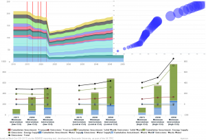
The developed reporting tool allows users to view results from the each infrastructure sector (e.g. transport or waster supply), or view cross sector results, a set of similar metrics computed for each sector allowing for direct comparisons between them on there performance. For each sector a range of model outputs can be viewed from the level of emissions produced, to the running costs per year to the cumulative capital investment required. Results are shown not only at the regional level, but where possible at the sub-national level through the government office regions for example where the models output data at this granularity. This allows the tool to show data not just in charts, but also through maps, allowing new insights to be learned which may not be identified through non-spatial results. More detail on the tool, along with images and the like will be provided in a specific post at a later date, but for now a small selection of images below exemplify the tool.

Drawing1

With the end of the project looming near an event was organised at the ICE in London on the 15th October where the key results and impacts from the project could be disseminated to a wider audience with those key members behind the research all being present to answer questions and discuss their work. At the event we were available to demo the reporting tool and discuss the complexities behind the database for those interested, while a set of slides were used to give a overview of our work. More generally two videos (below) were produced giving an overview of the project and the one on the resilience of the UK’s national infrastructure.

Summer 2015

After a long summer of glorious sunshine and topical temperatures the new academic year us upon us. Ok, so it may not have been that warm, or in fact that sunny, but that has not stopped us from getting on with our research.

To start with the PhD office has had a bit of a refurb, with a new coat of paint adorning the walls. As well as this, the wall, if you could call it that, between the two half’s of the room has been made permanent giving the PhD’s some piece and quite from the (excited?) undergraduates. At the same time the room was expanded to accommodate a further 8 desks, which brings me on to the next news..

Following the successful award of the DREAM CDT amongst other things, a total of 7 new PhD students are due to start in the coming weeks across both the geospatial engineering group and the geodesy group, meaning those new desks will soon be filled with excited and ambitious students.

And to round off the news on PhD students, Shaun Brown, Daniel Caparros-Midwood and Stephen Obrike have submitted or are about to, with both Shaun and Dan taking jobs up earlier in the year. All have clearly been making full use of their time, submitting within two weeks of their deadlines. A with all PhD submissions, the final step is the photo..

Shaun_Brown_Thesis

That’s all the PhD news for now, and more posts will follow on other activities during the summer and throughout the autumn. We have been busy…honest…


Pastures new for the nearly done boys

In the past few months two of our current PhD students have departed for pastures new, but of course neither could leave the field of geospatial science and technology.

Shaun has joined Ordnance Survey working within their photogrammetry team and assisting with the digitising of data from the collected aerial imagery. However, as an unforeseen consequence of this move (for this born and bread Newcastle supporter), he now wears the red and white colours of his adopted running club in Southampton. I’m not too sure he will ever live this down…

More recently Dan has left the group after six and a half (some may say eventful) years; three years as an undergraduate and the remainder as a PhD student. He has moved to AMEC in Shrewsbury where he now works as a GIS consultant. To our surprise we have been told the England students and lion’s student rugby league player has also retired from rugby as a result of this move, though we would not be surprised to hear otherwise when he next returns.

Good luck to them both and no doubt we will be seeing them again as they return for meetings and their viva’s throughout the next 6 months.

GISRUK 2015

A group of 6 staff and PhD students attended the annual UK GIS conference (GISRUK) being hosted by Leeds University. With all but one presenting (though now GISRUK regular Phil James was named on three of the six presentations), the groups diverse and interdisciplinary range of work which related to GIS was well covered.

Congratulations must be given to Neil Harris and Craig Robson who won best paper for their paper entitled “Real time coupled network failure modelling and visualisation”. No doubt this was (at least in part anyway) down to a live demonstration by Neil during the presentation of the developed software/framework which worked (or so it appeared to those less who hadn’t seen it before!). See below for a link to the abstract and presentation.

It was also good to see a number of alumni who have continued to work in the field of GIS upon departing our department after three years of study.

Finally a thanks to organizing committee for putting together a great conference and for the bursary awarded to Craig.

The official conference proceedings can be found here.

Links to the six presentations (and abstracts) are below:

  • “Real time coupled network failure modelling and visualisation”,  Neil Harris, Craig Robson, Stuart Barr and Phil James (Winning paper).
  • “Assessing the need for infrastructure adaptation by simulating impacts of extreme weather events on urban transport infrastructure”, Alistair Ford, Maria Pregnolato, Katie Jenkins, Stuart Barr, and Richard Dawson.
  • “Evolutionary Computing for Multi-Objective Spatial Optimisation”,  Daniel Caparros-Midwood, Stuart Barr and Richard Dawson.
  • “A geospatial relational database schema for interdependent network analysis and modelling”, David Alderson, Stuart Barr, Tomas Holderness, Craig Robson, Alistair Ford and Ruth Kennedy-Walker.
  • “Football fan locality- An analysis of football fans tweet locations”, Neil Harris and Phil James.
  • “Spatially modelling dependent infrastructure networks”, Craig Robson, Stuart Barr, Phil James and Alistair Ford

NERC Centre for Doctoral Training on Risk and Mitigation using Big Data award

School of Civil Engineering and Geosciences consortium awarded NERC Centre for Doctoral Training on Risk and Mitigation using Big Data.

The School of Civil Engineering, as part of a consortium between Cranfield, Newcastle, Cambridge and Birmingham Universities, have been awarded a NERC Centre for Doctoral Training on Risk and Mitigation using Big Data. The DREAM (Data, Risk And Environmental Analytical Methods) consortium comprises academics with expertise in environmental risk management and big data technologies and techniques. The consortium will train the next generation of risk specialists on the opportunities of ‘big data’ to improve our understanding of environmental risk mitigation options for industry, businesses, government and society. Over the coming years, DREAM will support 30 PhD students undertaking postgraduate research that seize the opportunities of ‘big data’ analytics to develop effective risk management strategies across the environmental sciences.

As part of the DREAM consortium, staff from the Water Resources and Geomatics research groups in the School of Civil Engineering and Geosciences will work with doctoral students on developing the next generation of big data and high performance computing approaches required to refine, scale and expand our ability to address key research questions being posed by industry and government in relation to risk assessment of geohazards, mitigation and management of extreme climate events, understanding and managing environmental risks faced by critical infrastructure systems and developing robust  long term sustainable protection plans of the Earths geobiophysical systems.

DREAM doctoral students at Newcastle will develop during the course of their research a comprehensive scientific skills set to address the challenges of risk mitigation in the environmental sciences. As our ability to monitor the Earth’s processes improves through a diverse range of different sources of data ranging from satellite observations through to ‘crowd sourcing’ it is imperative that modern environmental scientists are able to leverage maximum utility from the often diverse and large volumes of data available. DREAM students will receive training in how ‘Big Data Science’ can facilitate this, from the utilisation of different forms of high performance computing such as the cloud, utilising modern approaches to manage large heterogeneous environmental databases, through to the development of new computational approaches for analysis, modelling and synthesis of complex large volume environmental data-sets. In addition to developing skills in the use of ‘Big Data Science’ students will also receive project specific training in relation to environmental hazards, environmental impact and risk analysis methodologies, and training in risk mitigation and management.

The DREAM consortium is led in Newcastle University by Professor Chris Kilsby (Newcastle Director: chris.kilsby@newcastle.ac.uk) and Dr Stuart Barr (Academic Manager: stuart.barr@newcastle.ac.uk). Overall coordination of the consortium is being led by Cranfield University. Further details reading the award can be found at http://www.nerc.ac.uk/latest/news/nerc/bigdata/.